Midwest Mosaic: Navigating Through Chicago’s Weather Extremes
By
Amy Freeze
Explore the ever-changing weather patterns across the Midwest with a special focus on Chicago's cool evenings and upcoming storm threats. From sunny highs to stormy nights, here's everything you need to stay ahead of the weather.
This evening, Chicago enjoys mostly clear skies, but don’t be fooled. A stormy surprise is on the horizon with heavy rains expected from Iowa, coming our way!
Welcome to your in-depth look at the Midwest’s dynamic weather this week. Starting with a partly cloudy evening in Chicago with cooler airs setting the scene, we segue into an intense weather narrative across the Midwest. Stay prepared and informed as storms might escalate from Iowa to Chicago, bringing potential severe weather, while areas like Kansas City experience sweltering highs. Dive deeper into our daily and weekly forecast insights and learn how to effectively navigate through the ever-changing weather patterns.
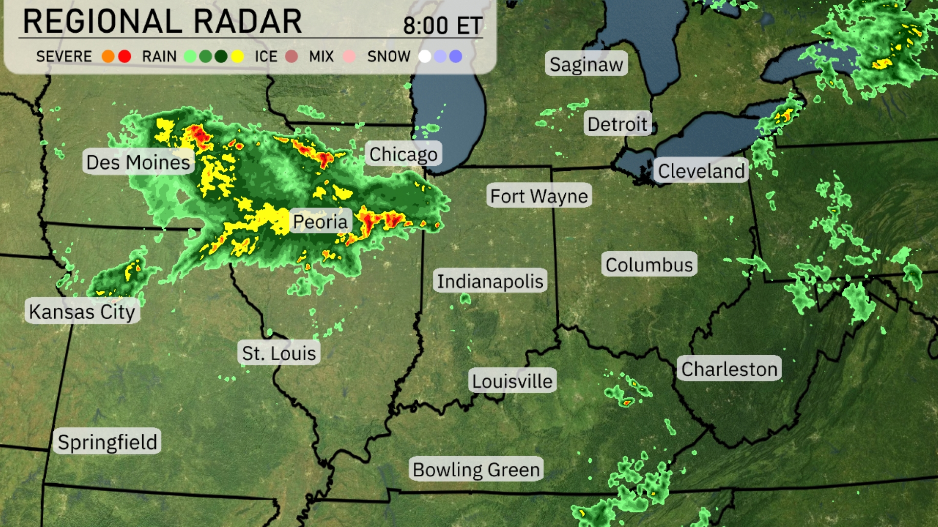
Heavy rain and thunderstorms are currently sweeping across parts of Iowa, making their way towards Chicago and Peoria. Des Moines is experiencing intense precipitation, with showers trailing towards St. Louis. Fort Wayne and the areas surrounding Columbus are seeing some lighter rain showers forming, potentially intensifying as the day progresses. Detroit, Cleveland, and Indianapolis are witnessing patchy rain, while southern areas such as Bowling Green and Louisville remain largely dry with intermittent cloud cover.
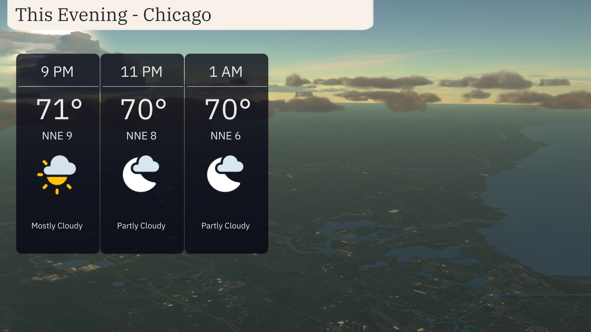
For this evening in Chicago, expect mostly clear skies transitioning to partly cloudy as the night progresses. Temperatures will gradually decrease from 71 degrees at 9 PM to 70 degrees by 1 AM. Winds will blow from the north-northeast at around 9 miles per hour, calming down to 6 miles per hour by early morning.
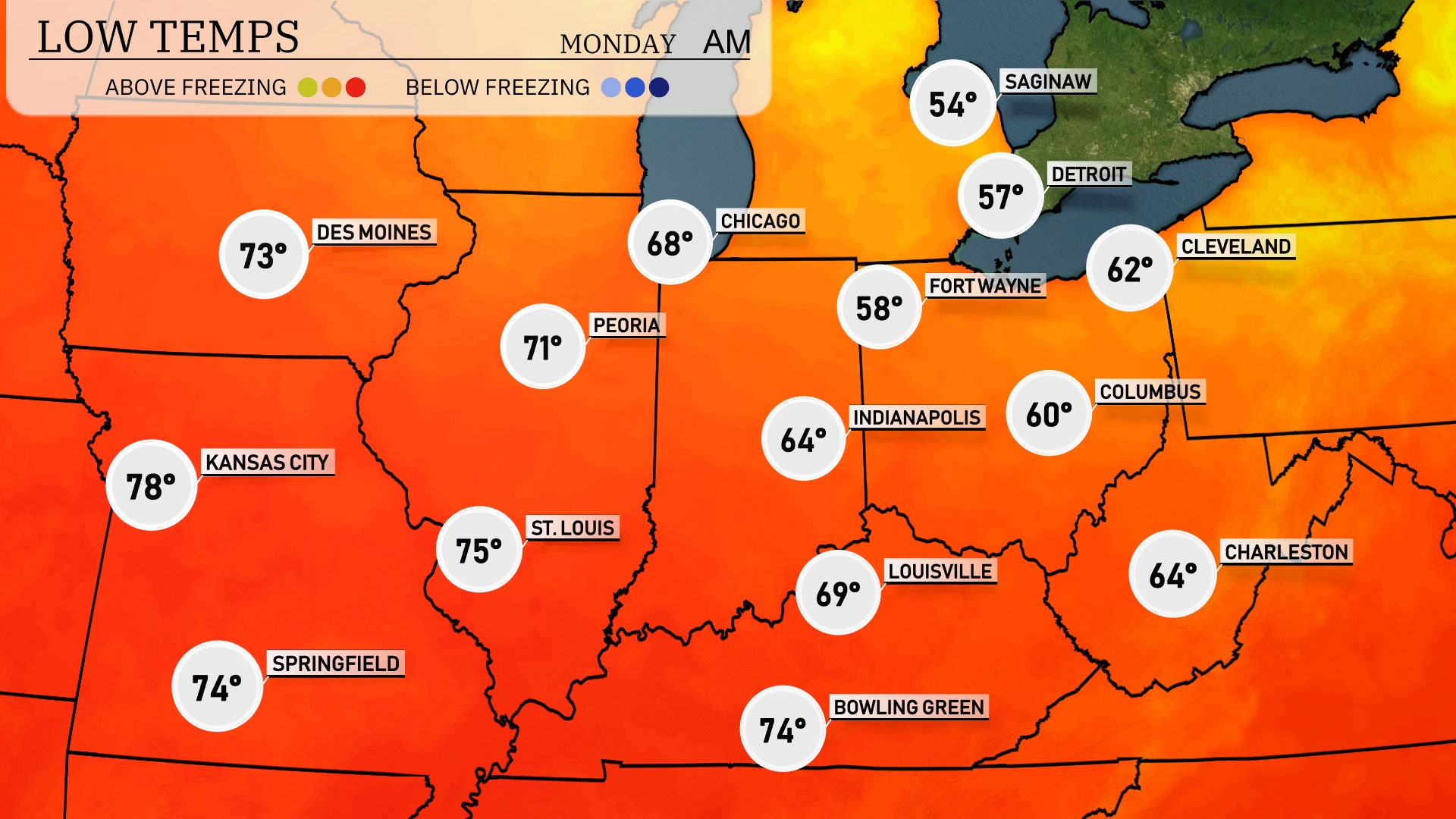
Tonight, temperatures will drop significantly across the Midwest. Chicago is expected to see a low of 68 degrees, while Fort Wayne will cool to 58 degrees. Indianapolis is looking at 64 degrees, and Columbus will have a low of 60 degrees. Expect Kansas City to remain a bit warmer at 78 degrees, but most areas will feel the cool air settling in.
Tomorrow in the Midwest, Kansas City will see a scorching high of 93 degrees, while St. Louis follows closely at 90 degrees. Springfield is set to reach a sweltering 95 degrees, significantly above average for this time of year. In the north, Peoria and Chicago will experience more moderate highs of 84 and 80 degrees, respectively. Expect Indianapolis and Louisville to also warm up nicely, hitting 80 and 86 degrees, as a high-pressure system blankets the region, contributing to these elevated temperatures.
A cold front is set to move across the Midwest, bringing scattered thunderstorms from Kansas City to St. Louis, with the potential for severe weather and localized flooding. Areas from Peoria to Indianapolis should prepare for heavy downpours and gusty winds, particularly in the late evening. Columbus and Charleston are also under the threat of storms, with conditions likely to persist into the early hours of Monday. Temperatures will see a mild drop after the frontal passage, with clearer skies expected by late Monday. Keep an eye on the forecast for any updates on severe weather alerts.
The UV index in Chicago will be moderate at 5 on Sunday, indicating a burn time of roughly 27 minutes in direct sunlight. On Monday, expect the UV index to increase to 8, with stronger sun exposure and a quicker burn time of 17 minutes. Remember to protect your skin with sunscreen and hats!
For the 7-day forecast in Chicago:
Sunday: Partly cloudy skies with a high reaching 75 degrees and a low of 68 degrees.
Monday: Mostly sunny and warmer, with a high of 81 degrees and a low of 69 degrees.
Tuesday: Enjoy partly cloudy conditions as temperatures climb to 88 degrees. The low will be around 75 degrees.
Wednesday: Mostly clear skies with a daytime high of 95 degrees and a low of 78 degrees.
Thursday: Expect showers to arrive later in the day with a high of 96 degrees and a low near 77 degrees.
Friday: Scattered thunderstorms likely, with highs near 87 degrees and an overnight low of 74 degrees.
Saturday: More scattered thunderstorms expected with the temperature peaking at 87 degrees and a low of 73 degrees.
Stay safe and enjoy the week ahead!