Clear Skies to Swift Storms: Navigating Salt Lake City’s Weather Shifts
By
Amy Freeze
Explore a week of fluctuating weather from serene stargazing evenings to unexpected stormy shifts in Salt Lake City with insights from Meteorologist Amy Freeze.
Meteorologist Amy Freeze guides you through a week of weather extremes in Salt Lake City, from perfect stargazing conditions to sudden snowy and rainy shifts. How does this impact your plans? Find out more.
Salt Lake City Evening News – Ahead in the Southwest: From clear skies perfect for stargazing to a cascade of weather changes including rain showers, snow activity, and brisk temperatures, the region sees it all. Join Meteorologist Amy Freeze as she provides detailed forecasts, explains the active weather radar, and provides tips for adapting to these rapid transitions. Whether you’re planning a quiet night under the stars or bracing for a chilly outdoor adventure, stay ahead of the weather curve with our comprehensive guide.
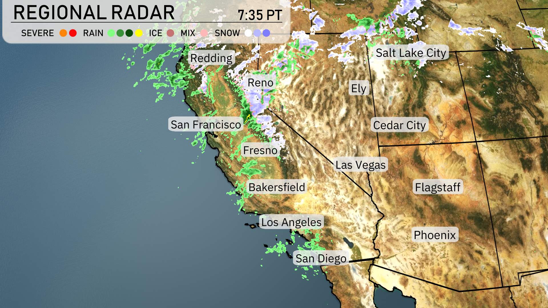
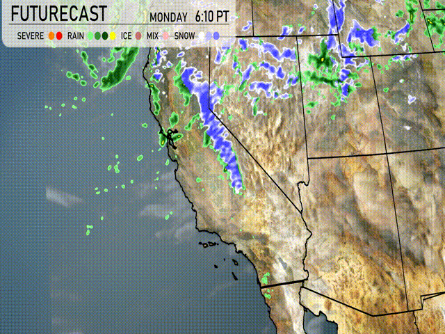
A look at the radar for the Southwest reveals an active weather pattern today. Rain showers are making their way inland from the Pacific, affecting the Northern California coast around Redding. Precipitation is also visible stretching down through Central California, impacting areas like Reno and Fresno, and even extending as far south as Bakersfield. Higher elevations surrounding Reno are seeing a wintry mix, with the probability of snow at the peaks.
Salt Lake City is under significant cloud cover, with some snow activity above 9-thousand feet, particularly in the higher elevations where icy conditions could be encountered. Cedar City is feeling cool but dry, as the majority of weather activity remains to the northwest.
In the southern stretch, the skies remain mostly dry for major metro areas like Los Angeles and San Diego, although some coastal clouds linger. Las Vegas also enjoys dry conditions. Farther east, Flagstaff is experiencing cloud coverage with chilly temperatures, while Phoenix remains unaffected with clear skies.
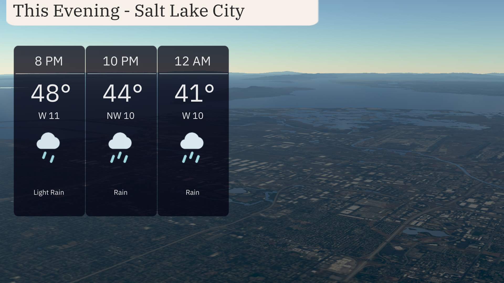
For this evening in Salt Lake City, temperatures will gradually decline from 48 degrees at 8 p.m. to 41 degrees by midnight. Light rain is expected initially, transitioning into more steady rain as the night progresses. Wind conditions start with an 11 mph breeze from the west at 8 p.m., shifting to a 10 mph northwest breeze by midnight
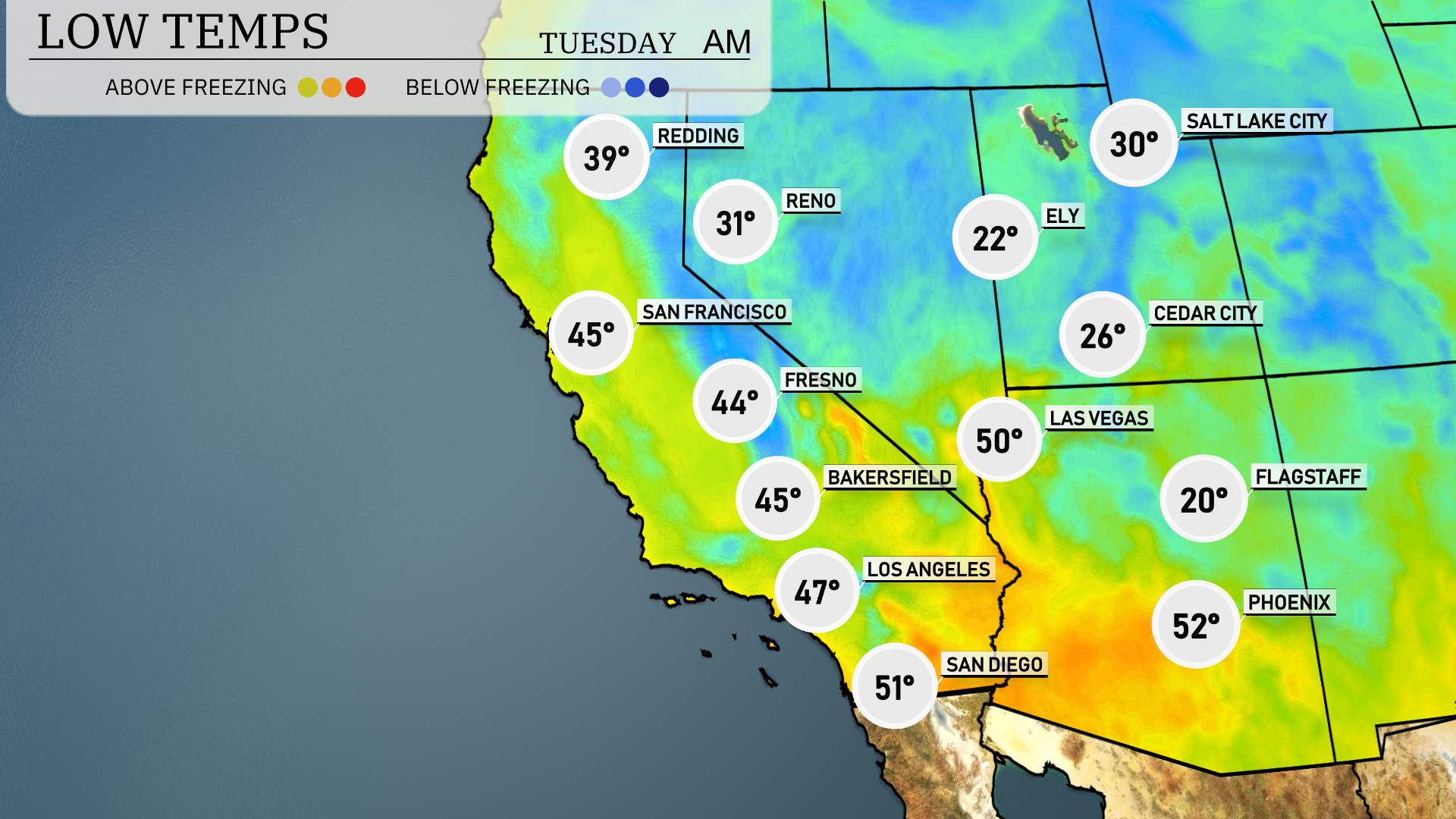
Tonight in the Southwest, expect some brisk temperatures as colder air moves into the region. In Cedar City, lows are forecasted at 26 degrees, while Flagstaff will drop to a frigid 20 degrees. Over in Las Vegas, temperatures will be cooler as well, reaching a low of 50 degrees. Phoenix will hold a slightly milder temperature of 52 degrees.
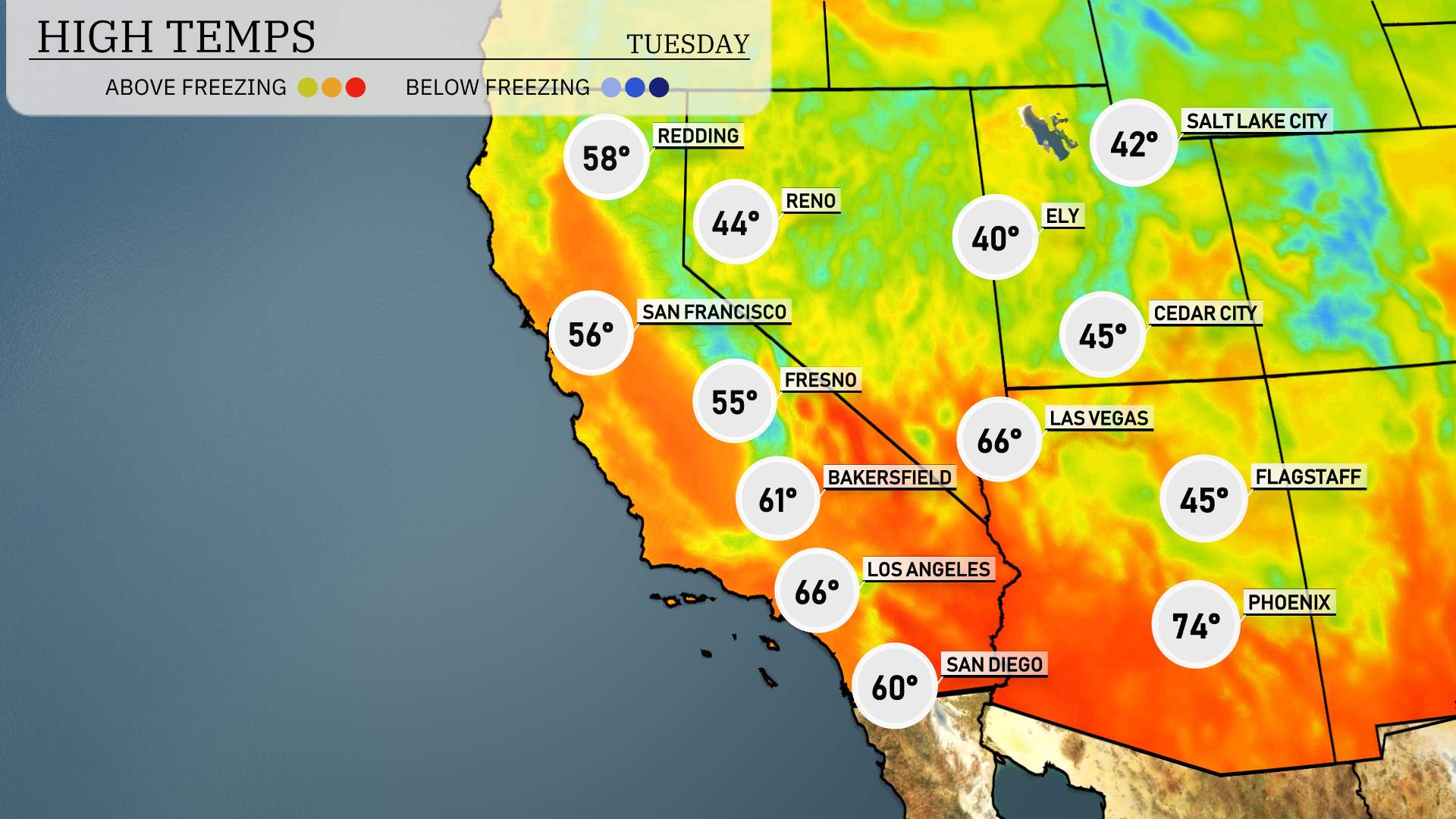
Here’s the regional high temperature rundown for the Southwest this Tuesday, April 1, 2025:
Las Vegas will be sizzling at 66 degrees, reflecting above-average readings for this time of year. Phoenix follows suit with a warm high of 74 degrees, also well above seasonal norms. In California, Bakersfield is expected to reach 61 degrees, while Los Angeles sees a high of 66. San Diego will enjoy a mild day with a high of 60 degrees.
San Francisco is forecasted for 56 degrees, and Fresno a bit lower at 55 degrees. Farther inland, Flagstaff is expected to reach just 45. High temperatures in the Southwest highlight a strong warming trend, especially in the southern areas where warm air is dominating the weather pattern.
Anticipate a shifting weather pattern across the Southwest tomorrow. A significant system is moving through Southern California into the Southwest region. On Tuesday, Central Arizona will experience rain showers which could lead to isolated flooding in low-lying areas. Portions of Nevada might see a brief period of snow and sleet, impacting travel through higher elevations. The storm will advance to New Mexico by evening, bringing the potential for thunderstorms with gusty winds. A cold front is set to bring temperatures down by nearly 15 degrees across the region.
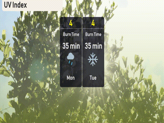
The UV index in Salt Lake City is moderate, with a value of 4 both Monday and Tuesday. Sun exposure could lead to a burn time of about 35 minutes in direct sunlight.
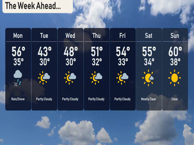
Monday: Rain and snow mix with a high of 56 degrees and a low of 35.
Tuesday: A partly cloudy day, cooler with a high of 43 degrees and a low of 30.
Wednesday: Expect partly cloudy skies, warming slightly to 48 degrees for a high and a low of 30.
Thursday: The weather continues to clear with partly cloudy conditions and a high of 51 degrees, while dipping to 32 at night.
Friday: More sunshine expected, reaching a high of 54 degrees and a nighttime low near 33.
Saturday: Mostly clear skies with temperatures hitting 55 degrees during the day and cooling to 34 at night.
Sunday: Clear skies, wrapping up the week with a high of 60 degrees and a low of 38.