Spring Surprises: NYC’s Weather Outlook from Sunshine to Showers
By
Amy Freeze
Amy Freeze guides you through a roller-coaster week of weather in NYC, from clear skies to potential showers. Discover what to expect as spring manifests in full swing!
Dive into the detailed weather predictions for New York City this spring as Meteorologist Amy Freeze provides daily insights on everything from temperature fluctuations to precipitation.
Welcome, New York City dwellers and visitors! As we navigate through spring, the weather can be as unpredictable as the bustling city streets. Meteorologist Amy Freeze is here to decode the skies, from tomorrow’s gentle morning breezes to the upcoming cold fronts expected late next week. A mix of sun and showers, keep your umbrella close and your sunglasses closer!
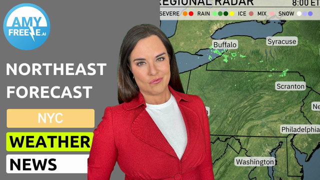
In the Northeast today, the regional radar displays a line of rain stretching from Washington D.C. up through New York City and onto Boston, where precipitation is heaviest. Rain is making its way eastward, affecting Philadelphia and extending into Albany. Farther up into Portland, snow is currently falling, indicating a wintry mix. While Syracuse and Buffalo enjoy clear skies at the moment, areas like Scranton are dealing with cloud cover as rain moves closer.
“New York City will see a brisk start to your morning with temperatures at 44 degrees by 7 AM under mostly sunny skies. By 9 AM, temperatures rise to 48 degrees with a western wind at 9 miles per hour and partly cloudy conditions. As you head toward late morning, expect sunny conditions and a temperature reaching 51 degrees, with winds continuing from the west at 9 miles per hour.”
High temperatures for the Northeast tomorrow are showing some variability as spring continues to make its presence known. In New York City, expect a high of 58 degrees, which is slightly above average for this time of year. Philadelphia will see warmer conditions, reaching 61 degrees; this is a nice uptick as we move into the latter part of March. Scranton’s high will be 51 degrees, also coming in around average.
In contrast, Pittsburgh will have a high of 54 degrees, while Syracuse is on the cooler side at 43 degrees, which is below typical March readings. Buffalo will struggle with just 39 degrees, reflecting a chilly air mass still lingering in the area. Boston is expected to hit 53 degrees, a pleasant afternoon ahead.
A cold front from the Great Lakes sweeps into the Northeast by late Tuesday morning, bringing widespread rain across the region, with heavier showers farther south in cities like Philadelphia and New York City. Expect winds to strengthen, especially along the coast, with gusts potentially reaching up to 30 mph in some areas. Temperatures will be on a roller-coaster ride, peaking in the low 50s on Tuesday before dropping to the low 40s overnight. In areas like Buffalo and Syracuse, the precipitation may transition to light snow as the colder air moves in.
The UV index in New York City will be low on Monday at 1, thanks to cloud cover and potential rain storms, which will keep exposure risks minimal. On Tuesday, the UV index rises to 5, indicating a moderate level of sun strength.
For the 7-day forecast in New York City:
Tuesday: Partly cloudy skies with a high of 57 degrees and a low around 40.
Wednesday: Expect showers late in the evening. We’ll see a bit cooler temperatures with a high of 52 degrees and a low of 35.
Thursday: Partly cloudy with a high of 52 degrees and a low of 41.
Friday: Look forward to partly cloudy conditions, with temperatures reaching a high of 61 and a low of 49.
Saturday: The clouds return, bringing a high of 55 degrees and a low of 43.
Sunday: Showers are expected throughout the day, with a high of 53 degrees and a cool low of 45.
Monday: Light rain continues with temperatures peaking at 51 degrees and dipping to 41 at night.