Navigating New York’s Sweltering Summer: Evening Updates and a 7-Day Forecast
By
Amy Freeze
Get the latest on NYC's weather patterns from scorching highs to thunderous evenings. See what the next 7 days have in store for the Big Apple!
New York City is seeing a mix of heat, thunderstorms, and cooler nights. Check out what the next few days will look like with our detailed forecast!
As New Yorkers enjoy the summer, the city’s weather is keeping everyone on their toes. From highs of 95 degrees to evening thunderstorms, staying prepared is key. Our comprehensive guide covers all you need to know from upcoming rain showers to optimal times to dodge the heat. Check our in-depth analysis for a safe and enjoyable week.
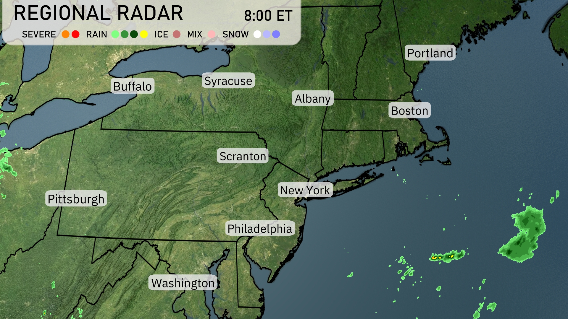
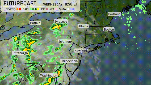
A relatively calm morning across the Northeast region is seen on the radar. Scattered light rain is skirting just offshore east of Boston and far off the coast of New York City, leaving these urban areas dry at the moment. Syracus, Albany, and Buffalo are currently experiencing clear skies, providing a breather from any rain or storms. The current setup suggests dry and clear conditions will persist across much of the region for the day.
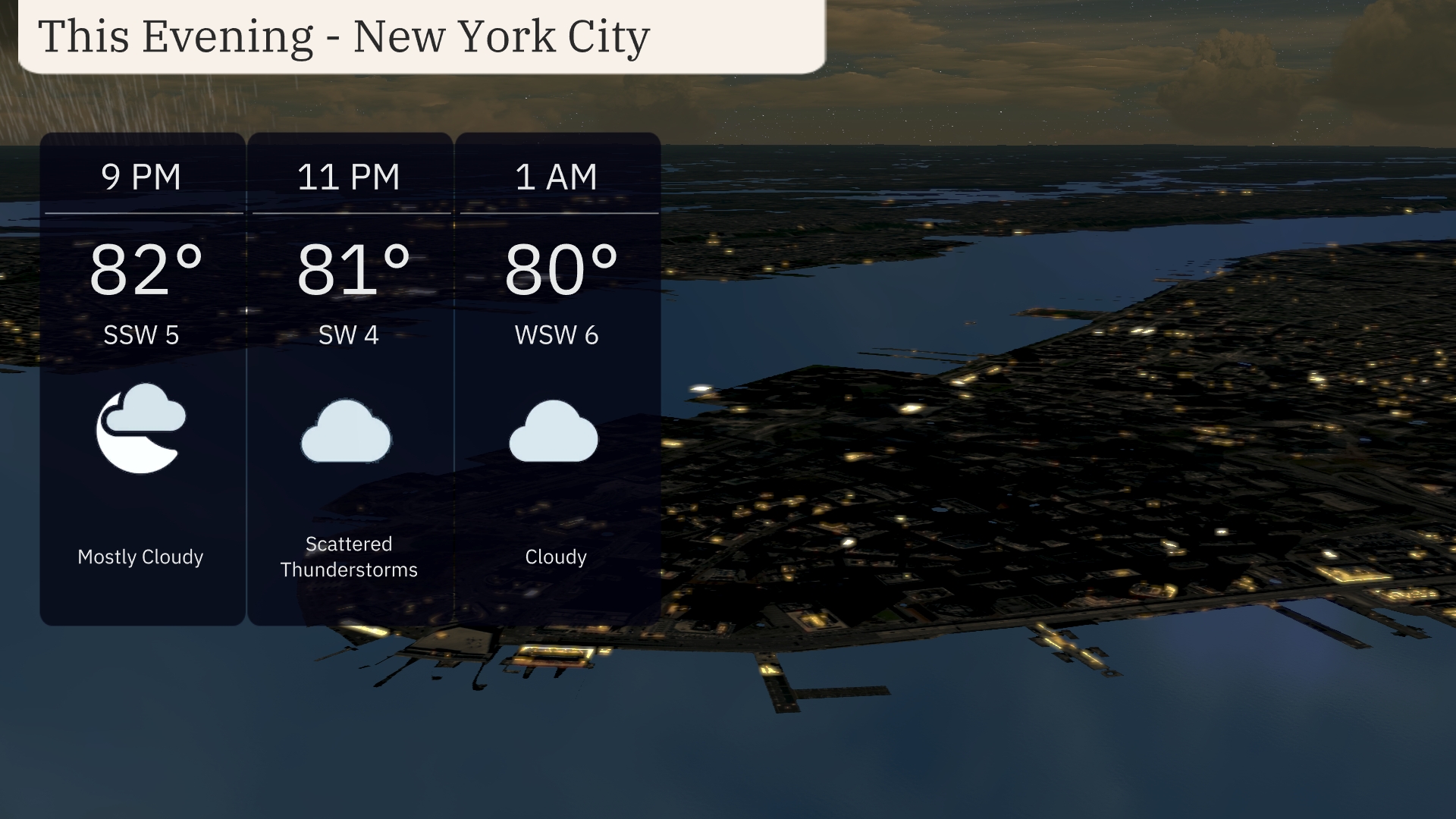
Evening temperatures in New York City will be in the low 80s, starting at 82 degrees by 9 PM and cooling slightly to 80 degrees by 1 AM. Winds will shift from the south-southwest at 5 mph to west-southwest at 6 mph. Expect mostly cloudy skies early, with scattered thunderstorms developing around 11 PM. Cloud cover will persist into the night, bringing a chance of rain.
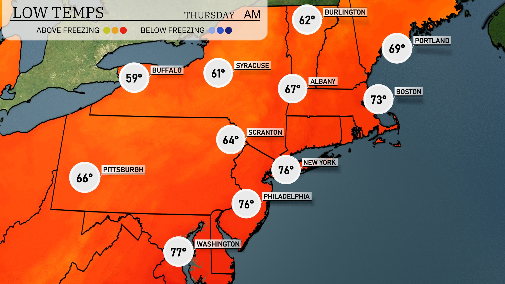
Tonight in the Northeast, Buffalo will dip to a low of 59 degrees, while Syracuse cools down to 61. Scranton is expected to see a low of 64, with New York City only slightly warmer at 76 degrees. Boston will end the night around 73 degrees, which is notably cooler than recent days.
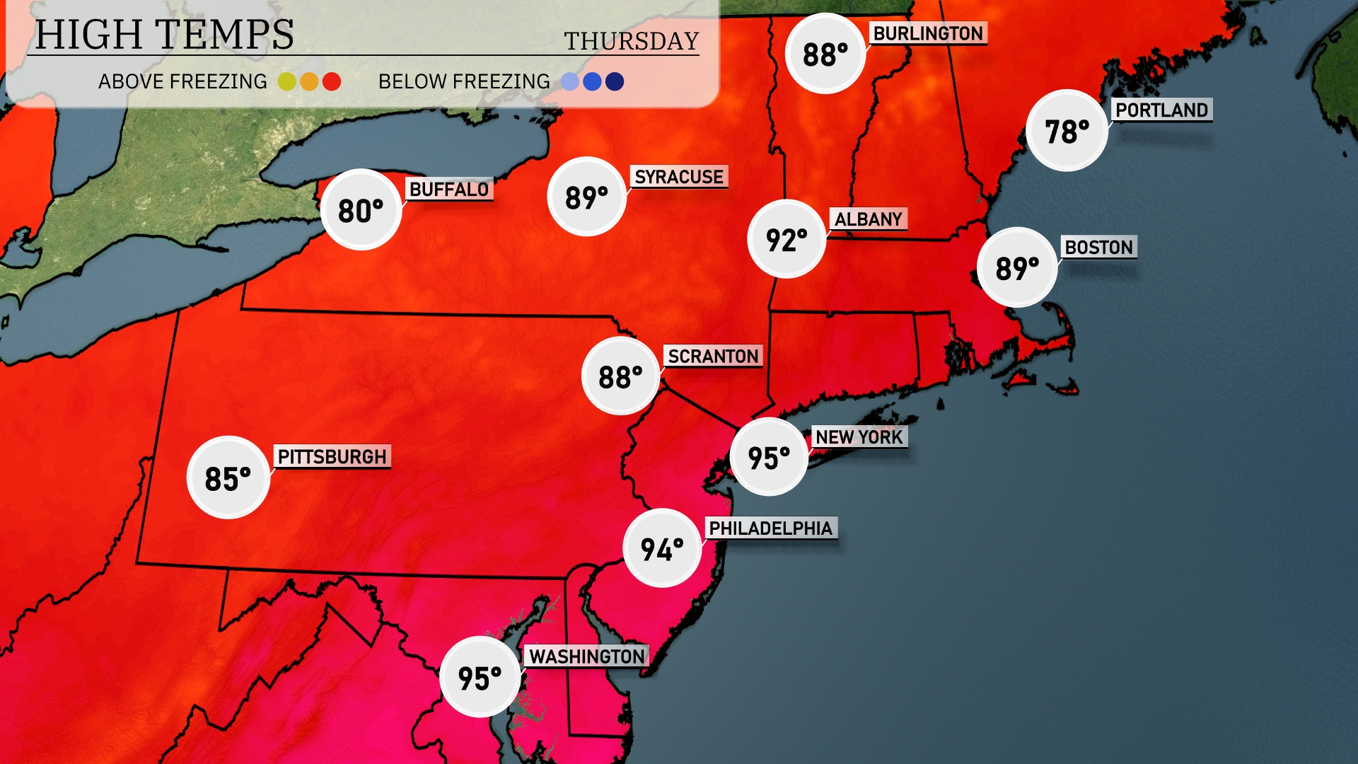
Tomorrow, the Northeast will experience notably high temperatures. New York City will hit 95 degrees, while Philadelphia isn’t far behind at 94 degrees. Buffalo will see a high of 80 degrees, and Syracuse is expected to reach 89 degrees. Most areas are running above average for this time of year, influenced by a strong high-pressure system keeping skies mostly clear. Cooler temps will be felt in Portland, with a high of 78 degrees, providing some relief from the heat.
A cold front is moving through the Northeast, bringing rain showers and occasional thunderstorms from Pittsburgh to Syracuse and Scranton by tomorrow morning. Expect the heaviest rain around Syracuse and Scranton, with potential for localized flooding. Washington D.C. and Philadelphia will experience scattered showers early in the day. New York City and Boston might stay mostly dry, though clouds will increase. Temperatures will remain mild with a slight dip in the afternoon as the front passes through.
Today’s UV index in New York City is very high, reaching 9 both Wednesday and Thursday, which means a burn time of just 15 minutes in direct sunlight.
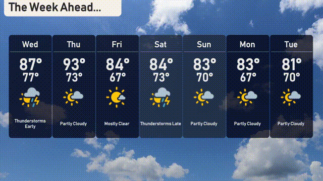
For the 7 Day Forecast in New York City:
Wednesday: Thunderstorms early with a high of 87 degrees and a low of 77 degrees.
Thursday: Partly cloudy skies, warming up to 93 degrees with a low of 73 degrees.
Friday: Mostly clear conditions with a high reaching 84 degrees, cooling to 67 degrees at night.
Saturday: Thunderstorms late in the day, with daytime temperatures around 84 degrees and a low of 73 degrees.
Sunday: Enjoy partly cloudy weather with a high of 83 degrees and a nighttime low of 70 degrees.
Monday: Continue to enjoy partly cloudy skies, with highs hitting 83 degrees and a low of 67 degrees.
Tuesday: The clouds linger with a high of 81 degrees and a low near 70 degrees.