New York’s Weather Whiplash: Sunny Spells followed by Thunderous Threats
By
Amy Freeze
Explore the contrasting weather patterns over New York this week, from tranquil clear skies to the looming threat of thunderstorms, with insights from Meteorologist Amy Freeze.
This week in NYC offers a diverse weather palate—clear nights leading to storm-laden days. Discover what’s in store with your trusted meteorologist, Amy Freeze.
Welcome to a week of meteorological contrasts in NYC—clear skies provide a serene backdrop tonight, only for the narrative to switch dramatically. A pending cold front threatens with gusty winds and rain. Join Meteorologist Amy Freeze as she guides us through each day’s potential surprises with detailed forecasts.
The Northeast region is currently experiencing scattered rain showers, with the heaviest precipitation focused around Boston, extending eastward toward the Atlantic. Light rain is spreading across most of Maine and parts of New Hampshire, impacting Portland with steady showers. Albany and Syracuse are under cloudy skies, while regions westward toward Buffalo are keeping dry. New York City and Philadelphia remain clear and dry for now, but cloud cover is increasing from the north. Washington, D.C. is enjoying calm conditions with no precipitation in sight.
Temperatures in New York City this evening start at 66 degrees at 9 PM, gradually cooling to 61 degrees by 1 AM. Clear skies dominate the forecast, providing excellent visibility. Winds remain gentle, transitioning from northwest at 3 miles per hour to west-northwest, maintaining a calm and serene night.
Tonight in the Northeast, Philadelphia cools down to 56. Scranton will be a bit cooler at 48 degrees, and Syracuse is forecasted to reach 44. Buffalo will have a low of 48, and Boston will experience a chilly 45 degrees. Burlington will cool to 44, making for a brisk evening across the region.
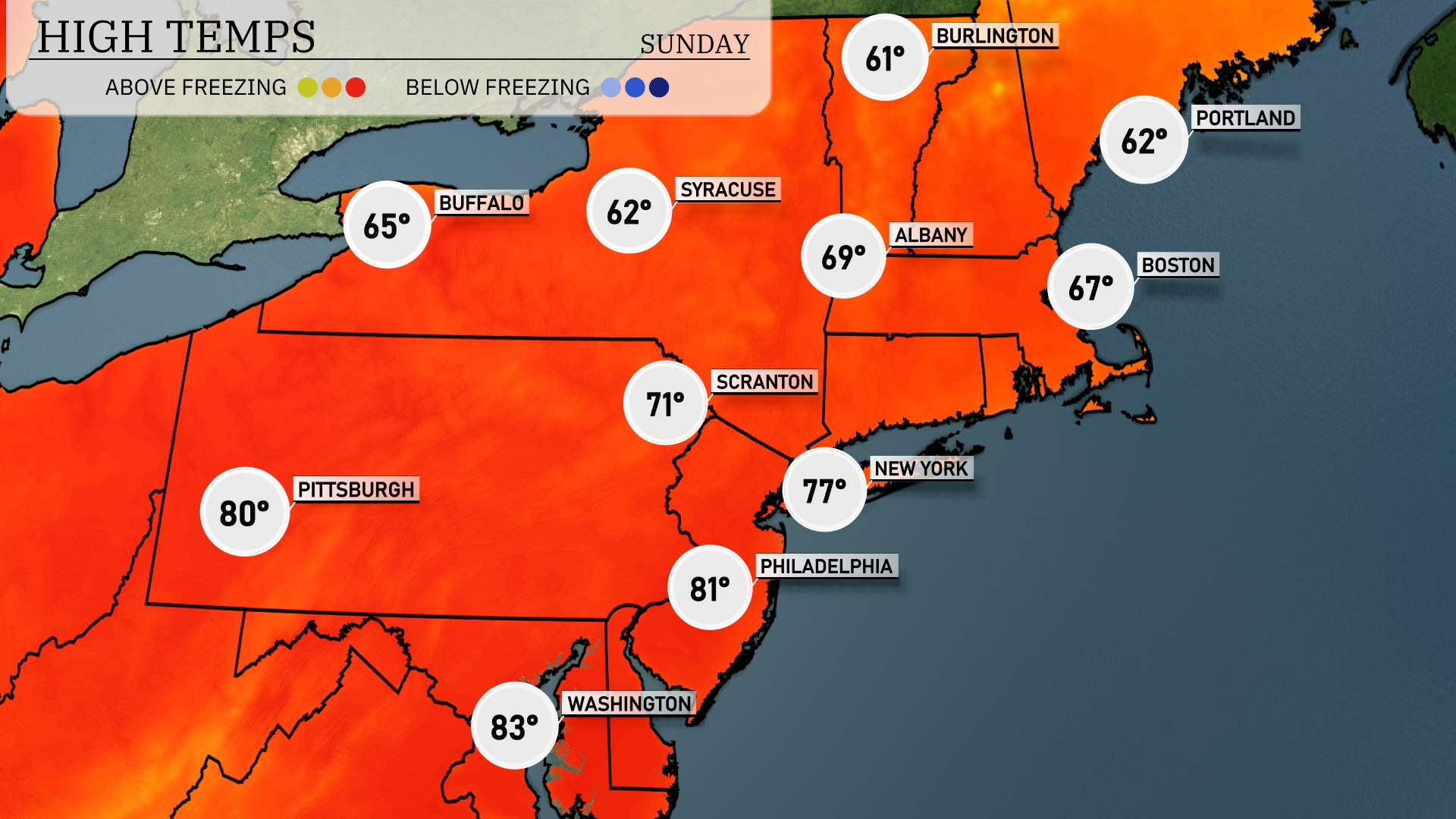
High temperatures in the Northeast tomorrow will be notably warm for this time of year, Pittsburgh is looking at a high of 80 degrees, while Philadelphia will hit 81 and Boston will see a high of 67. Farther north, Albany reaches 69 degrees, and Syracuse is slightly cooler at 62.
A cold front is set to sweep across the Northeast tomorrow, bringing rain and potential thunderstorms starting in the morning from Pittsburgh to Scranton. Expect heavy rain and gusty winds that could impact the area through late afternoon. The greatest threat for severe weather, including the chance for isolated thunderstorms, will be in the Boston and New York City areas by early evening. Temperatures will steadily drop by 5 to 10 degrees behind the front, leading to a cooler and less humid atmosphere by Sunday morning. Prepare for soggy conditions and heed any severe weather alerts if you’re in these affected areas.
The UV index in New York City for Saturday and Sunday is 8, which is considered very high. This means you could experience sunburn in about 17 minutes if you’re out in direct sunlight without protection.
For the 7-day forecast in New York City:
Saturday: Clear skies with a comfortable high of 73 degrees and a low of 57.
Sunday: Mostly clear, warming up to 76 degrees during the day with a low of 55 degrees.
Monday: Expect cloudy conditions with a high reaching 75 degrees and a low of 62.
Tuesday: Showers are likely, bringing a high of 69 degrees and a low of 58.
Wednesday: More showers expected with temperatures peaking at 65 degrees and a low of 61.
Thursday: Mostly cloudy skies with a high of 71 degrees and a low of 63.
Friday: Showers anticipated late in the day with a high of 76 degrees and a low of 65.