Dive into our detailed forecast with Amy Freeze as we explore a dramatic blend of clear skies, swift showers, and chilling temperatures across New York City and beyond. Don’t miss the key highlights for the next seven days.
Meteorologist Amy Freeze provides an insightful glance at this week’s weather across NYC and the Northeast—expect a mix of clear skies, rain, and varying temperatures. Plan effectively with our detailed daily breakdown.
Get ready for a weather rollercoaster! This week, New York City sees a remarkable shift from balmy clear skies to rapid rain showers and a drop in temperatures, resonating through the Northeast. As outlined by Amy Freeze, anticipate conditions ranging from serene to stormy, with detailed insights on how these changes could impact your week. From Buffalo’s brisk showers to Boston’s chilly nights, stay ahead with our comprehensive 7-day forecast, calibrated for the best preparation against nature’s unpredictability. Plus, don’t overlook your weekend plans as we cover expected weather variations and how they could shape outdoor activities.
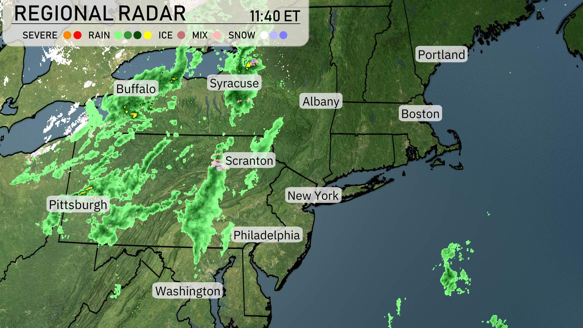
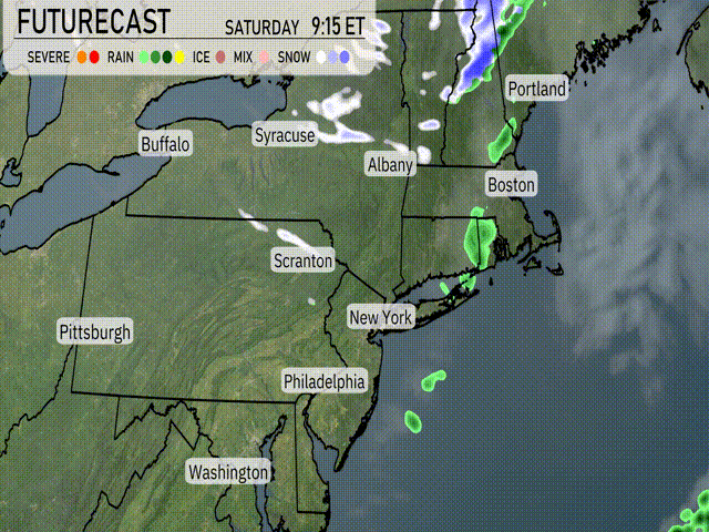
On the Regional Radar for the Northeast, there’s a substantial stretch of rain showers extending from the Great Lakes into the upstate New York and interior Pennsylvania. Buffalo and Syracuse are experiencing moderate rain, with a line of showers sweeping eastward towards Scranton and Albany.
Pittsburgh is also seeing rainfall as part of this system moving through. Farther south, the showers are approaching the Philadelphia area with light to moderate intensity. Washington D.C. remains dry for now.
Boston and New York City are also clear, though clouds are likely to move in with the advancing system. Portland remains dry at this hour, though some scattered rainfall is edging closer to the region. Stay alert for weather updates as conditions evolve throughout the day!
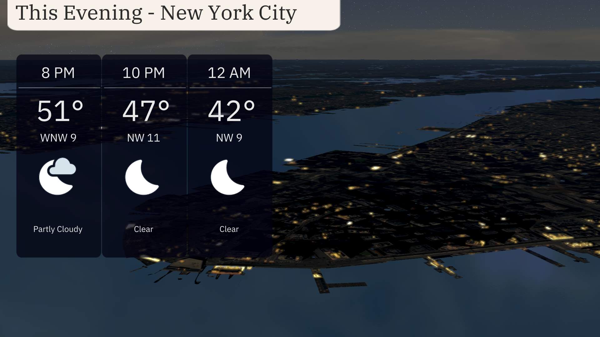
For this evening in New York City, anticipate partly cloudy skies transitioning to clear conditions as the night progresses. Temperatures will start at 51 degrees at 8 PM, declining to 47 degrees by 10 PM, and reaching 42 degrees by midnight. Winds will shift from west-northwest at 9 miles per hour to 11 miles per hour, providing a gentle breeze during the evening hours.
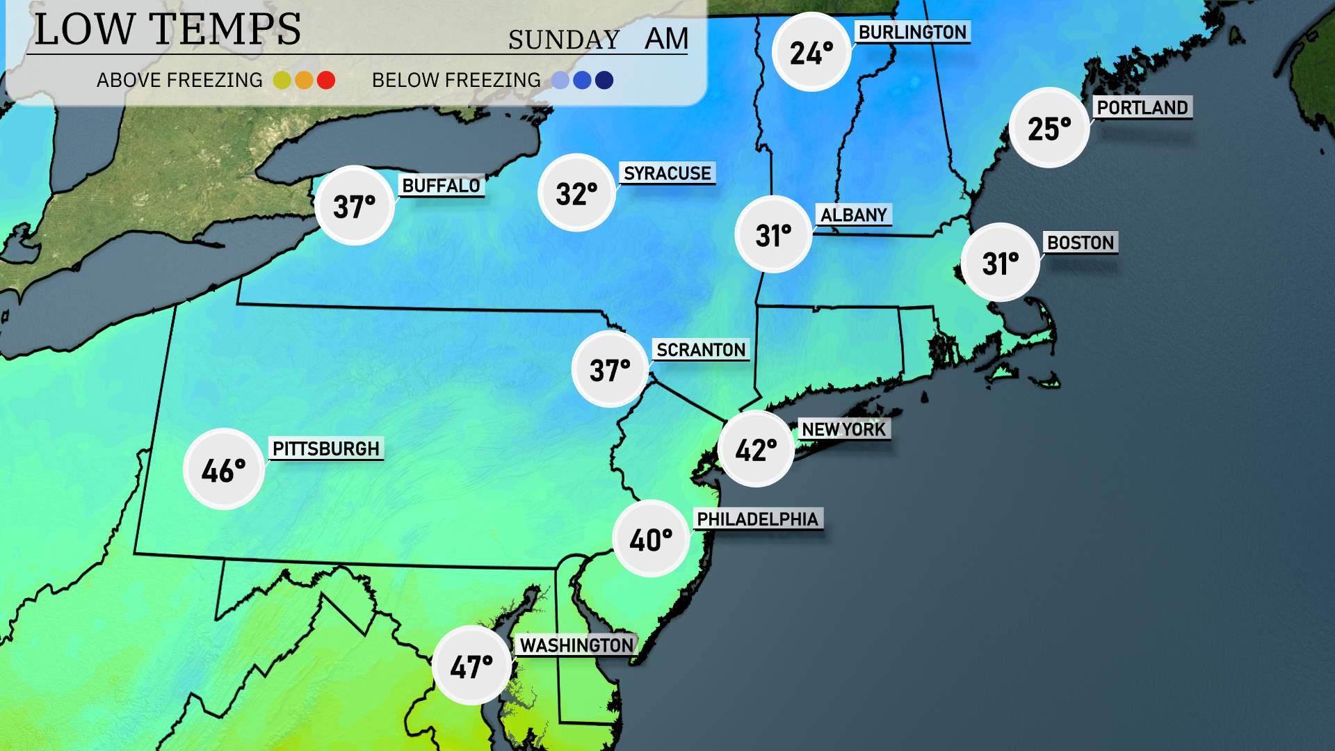
A noticeably chilly air mass is settling in, making for a brisk night across the region. Expect 25 degrees in Portland. Boston will see a low of 31, while Albany also dips to 31. Scranton is forecasted at 37, with Philadelphia slightly milder at 40. New York City will experience a low of 42 degrees. Pittsburgh rounds out the night at 46 degrees.
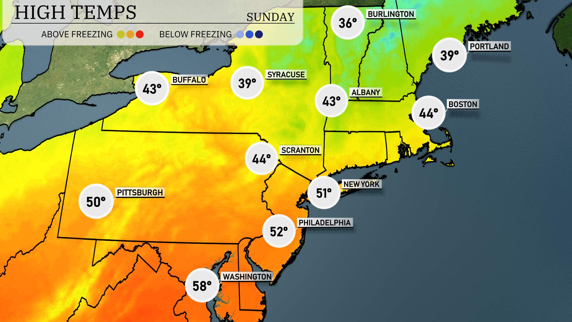
High temperatures for tomorrow across the Northeast region are trending above-average in many areas. New York City will see a high reaching 51 degrees. Philadelphia is expected to warm up to 52 degrees, while Pittsburgh will hit 50 degrees. Further north, Syracuse is looking at a cooler 39 degrees, and Buffalo will have a high of 43 degrees.
Albany is forecasted for 43 degrees, and Boston will reach 44 degrees.
“A developing weather system in the Northeast will bring changing conditions starting early Saturday. Expect a wintery mix, with snow transitioning to rain across areas from Syracuse to Portland. Temperatures will hover in the low 30s, creating the potential for sleet and icy roads. A surge in temperatures by late afternoon will turn precipitation to rain, particularly impacting Boston and New York City with brief heavy downpours. In western areas like Pittsburgh, conditions remain dry with partly cloudy skies. Stay alert for potential flood watches in areas prone to quick runoff, especially with snowmelt.”
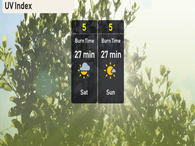
“The UV index in New York City will be moderate this weekend with a value of 5 on both Saturday and Sunday, indicating a burn time of about 27 minutes in direct sunlight. Be sure to wear sunscreen and enjoy your time outdoors safely!”
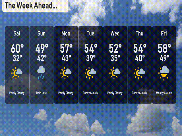
For the 7-day forecast in New York City:
Saturday: Partly cloudy skies with a high of 60 degrees and a low of 32 degrees.
Sunday: Rain is expected late with temperatures dropping to a high of 49 degrees and a low of 42.
Monday: Look forward to mostly sunny conditions with a high reaching 57 degrees and a low of 43.
Tuesday: Partly cloudy with a bit of chill, the high will be 54 degrees, dipping to 39 at night.
Wednesday: Expect partly cloudy skies again with a high of 52 degrees and a low of 35.
Thursday: Partly cloudy with temperatures around 54 degrees during the day and 40 degrees at night.
Friday: Wrap up the week with mostly cloudy skies and slightly warmer temperatures, hitting a high of 58 degrees and a low of 49.