Northeast Weather Update: A Tale of Clouds and Clarity
By
Amy Freeze
Meteorologist Amy Freeze offers a comprehensive look at today's weather dynamics across New York City and the Northeast, from thunderstorms to calming winds.
Discover the latest weather patterns affecting NYC and the Northeast. From pleasant breezes to impending storms, find out what to expect right outside your front door.
Amy Freeze provides a detailed look at the fluctuating weather conditions across the Northeast. Today, NYC enjoys partially clear skies, while nearby areas like Philadelphia brace for rain. With a comprehensive 7-day forecast, find out how the rest of the week is shaping up with potential storms and sunny breaks.
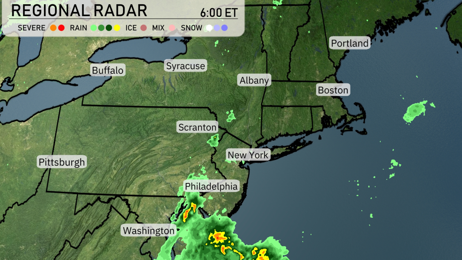
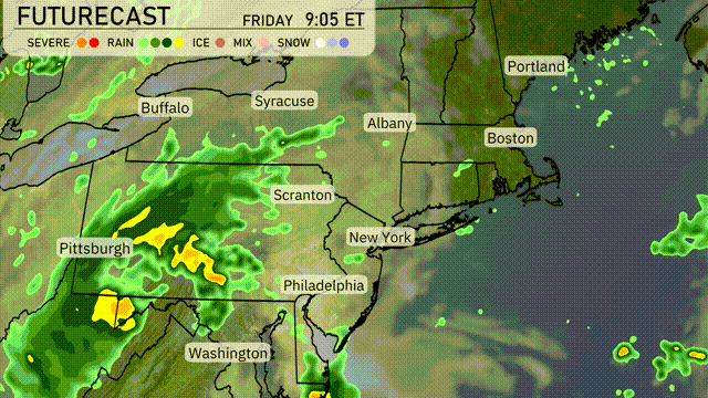
In the Northeast today, heavy rain is centered around the Philadelphia area, gradually moving northeast toward Scranton. Thunderstorms are popping up and intensity should be watched closely as they make their way into the region. To the north, cities like Albany and Boston are seeing clear skies for now, providing a temporary break from stormy weather. Buffalo is experiencing light showers, which are spreading eastward towards Syracuse.
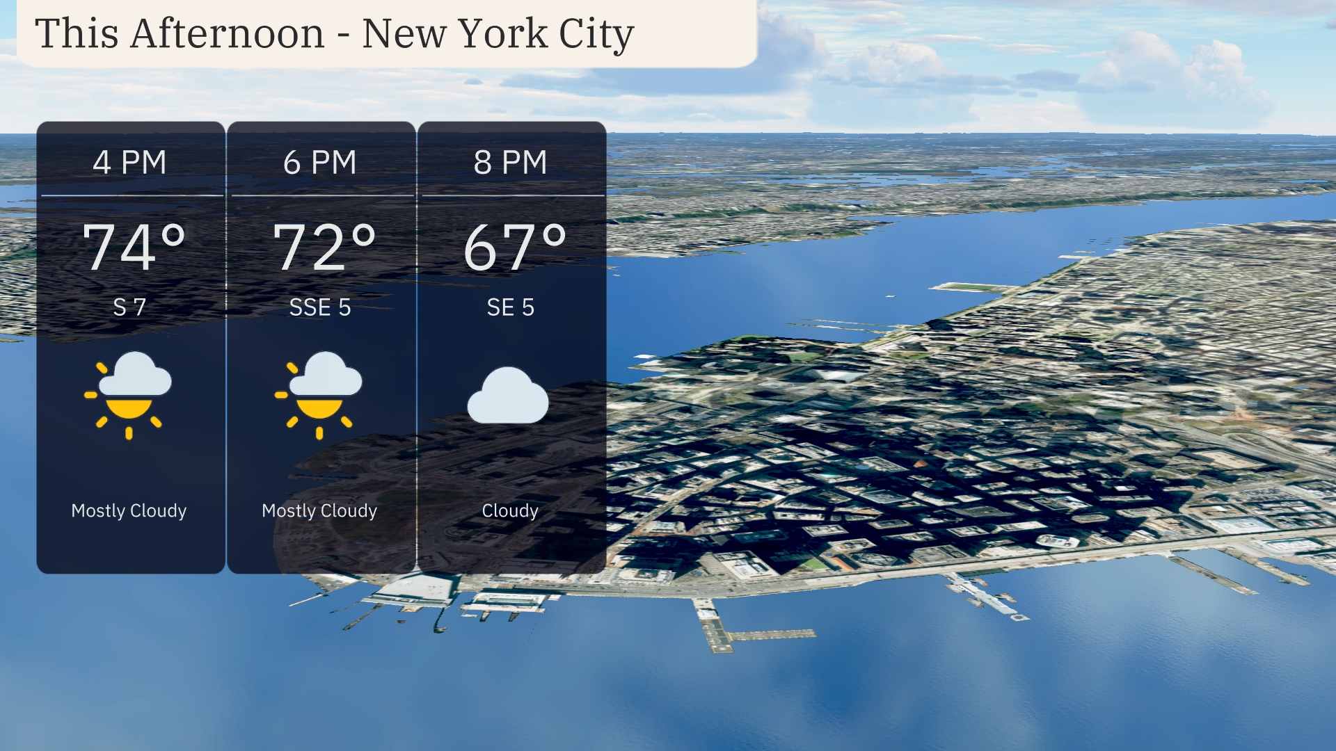
Temperatures in New York City this afternoon are expected to reach 74 degrees at 4 PM, with a gentle 7 mph wind from the south. By 6 PM, temperatures will slightly drop to 72 degrees as the wind shifts from the south-southeast at 5 mph, maintaining mostly cloudy skies. Cloud cover increases into the evening at 8 PM with temperatures cooling to 67 degrees and a calm breeze continuing out of the southeast at 5 mph.
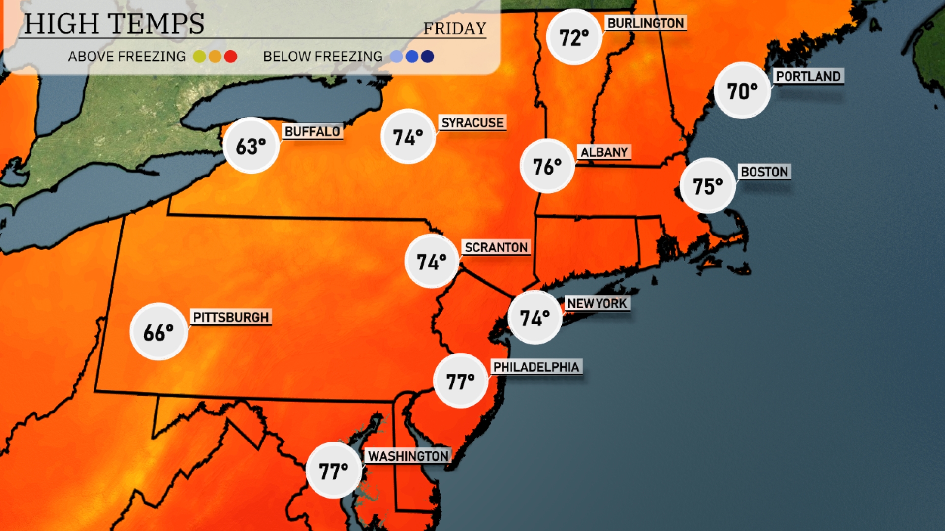
Today’s high temperatures in the Northeast are shaping up nicely. In New York City, expect a high of 74 degrees, while Boston will reach a comfortable 75. Philadelphia will warm up to 77 degrees, making it the warmest spot in the region today. Farther north, Albany hits 76 degrees, while Syracuse cools off slightly with a high of 74. Buffalo is on the chilly side, with a high of just 63 degrees.
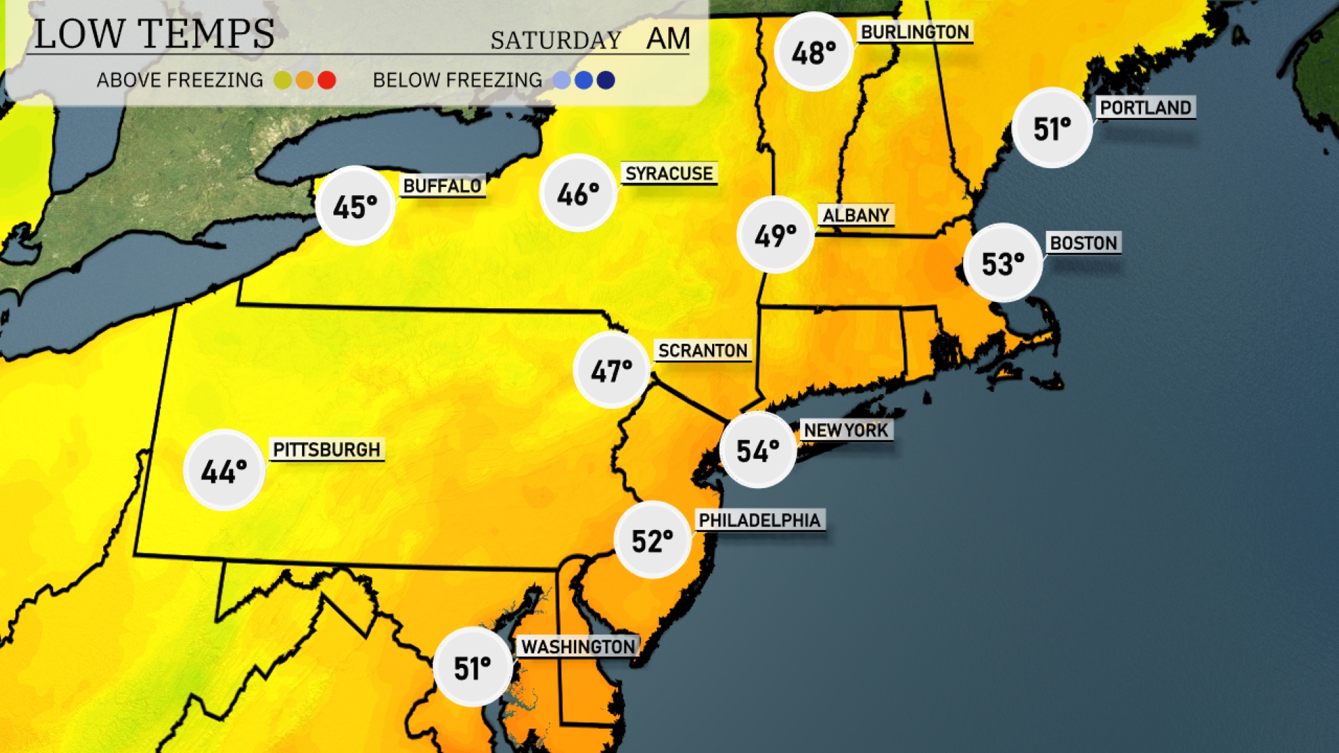
Tonight expect a low of 44 degrees in Pittsburgh and 46 in Syracuse. Scranton will chill down to 47 degrees, while New York City will see a milder low of 54. Philadelphia is forecasting a low of 52, and Boston will drop to 53 degrees.
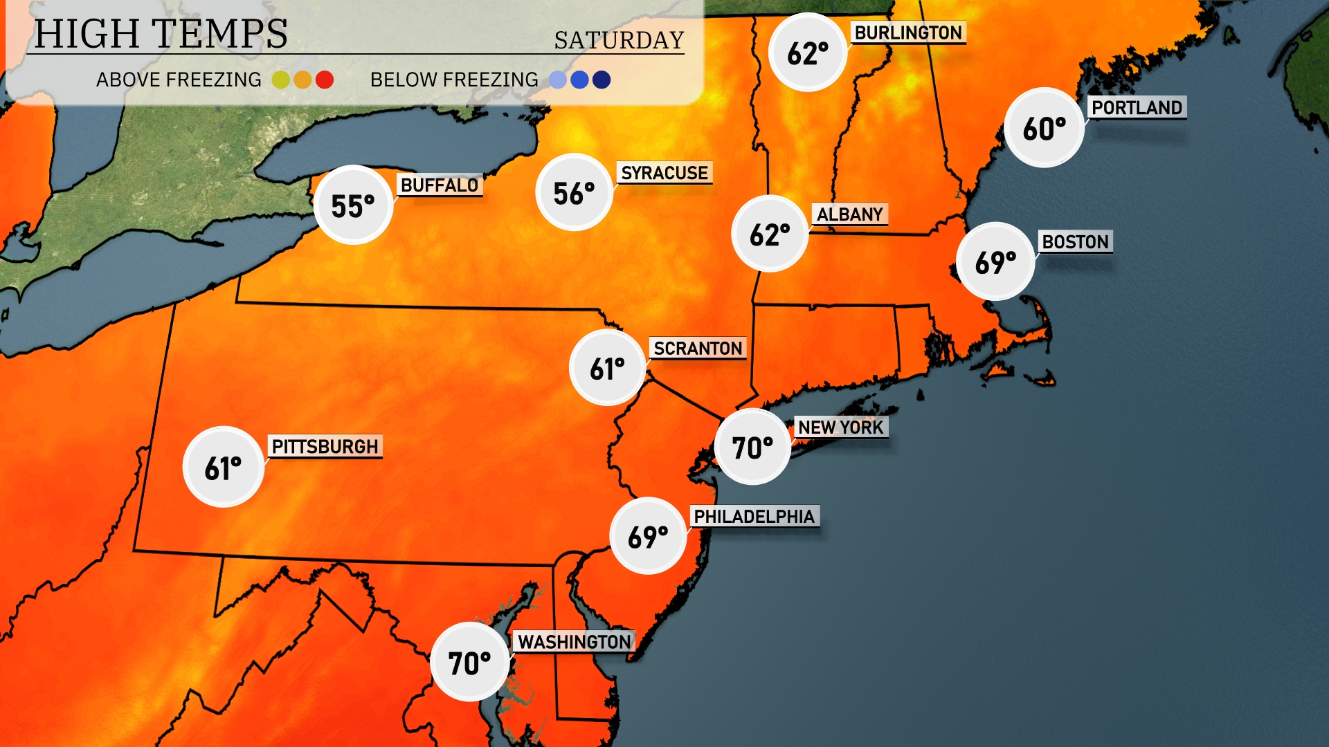
Tomorrow New York City is set to reach a high of 70 degrees, while Philadelphia will match that with the same temperature. Boston is expected to see a high of 69 degrees, with clear skies allowing for warm conditions. Farther north, Syracuse will struggle to reach just 56 degrees, showing a stark contrast. Pittsburgh also stays comfortable at 61 degrees, rounding out a warm day for much of the region.
A low-pressure system will make its way into the Northeast tomorrow, bringing widespread clouds and rain from Pittsburgh to New York City. Expect heavier showers in areas like Scranton and Philadelphia with the potential for localized flooding due to persistent downpours. Temperatures will hover in the mid to high 60s, slightly cooler than average. As the system progresses, look out for gusty winds in Buffalo and Syracuse. Weekend plans may need adjustment as the weather remains unsettled before clearing up late Sunday.
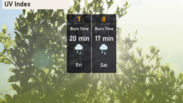
Today in New York City, the UV index reaches a high of 7, with a potential burn time of 20 minutes if it’s not cloudy. Anticipate similar UV levels tomorrow, with an index of 8 which could result in a 17-minute burn time in direct sunlight.