NYC Evening Insights: A Glimpse into the Week’s Weather Dynamics
By
Amy Freeze
Dive into a comprehensive look at NYC's weather this week—from tonight's gentle breezes to the scattered showers affecting the Northeast. Join Amy Freeze as she uncovers what's in store!
Meteorologist Amy Freeze gives an inside look at NYC’s evening weather, from cool temperatures to expected showers across the Northeast. Perfect reading for those planning their week.
This detailed post provides an in-depth view of tonight’s weather in New York City and the broader Northeast area. Meteorologist Amy Freeze discusses temperature trends, the arrival of light showers, and what these changes mean for your plans in the coming days. From the calm skies over NYC to potential rains in Albany, stay ahead with her expert forecasts and prepare effectively.
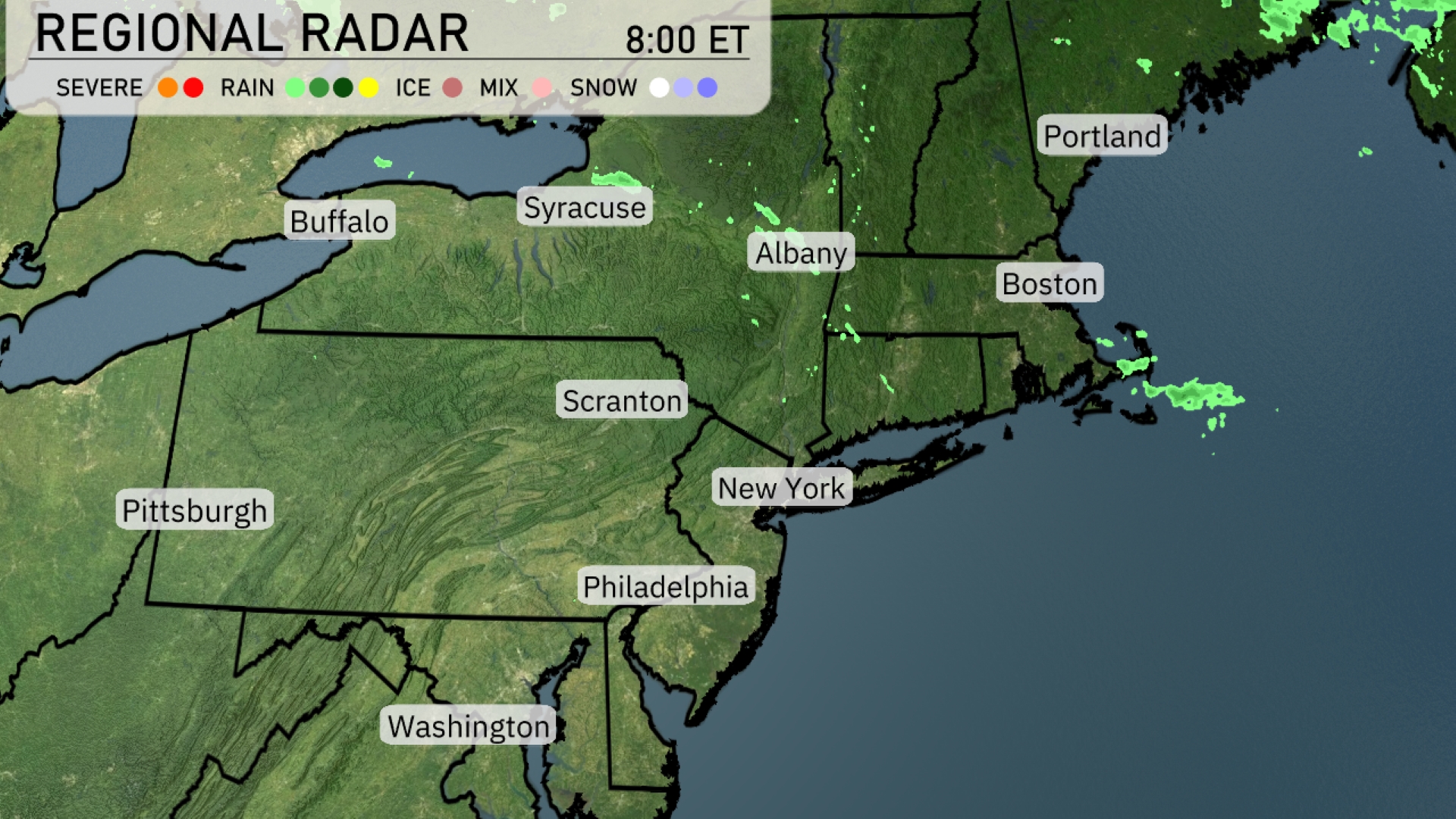
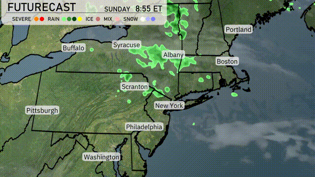
The Northeast region is experiencing generally clear and calm conditions. Light rain showers are sweeping through Syracuse and north of Albany, with areas around Boston also seeing some light precipitation. There’s a potential for scattered showers to continue moving eastward, impacting parts of southern Vermont and New Hampshire. The remainder of the region, including New York City, Philadelphia, and Pittsburgh, is currently dry, with skies predominantly clear or partly cloudy. Keep an eye on the skies as these light showers may affect your plans, especially if you’re heading out in Boston or Albany.
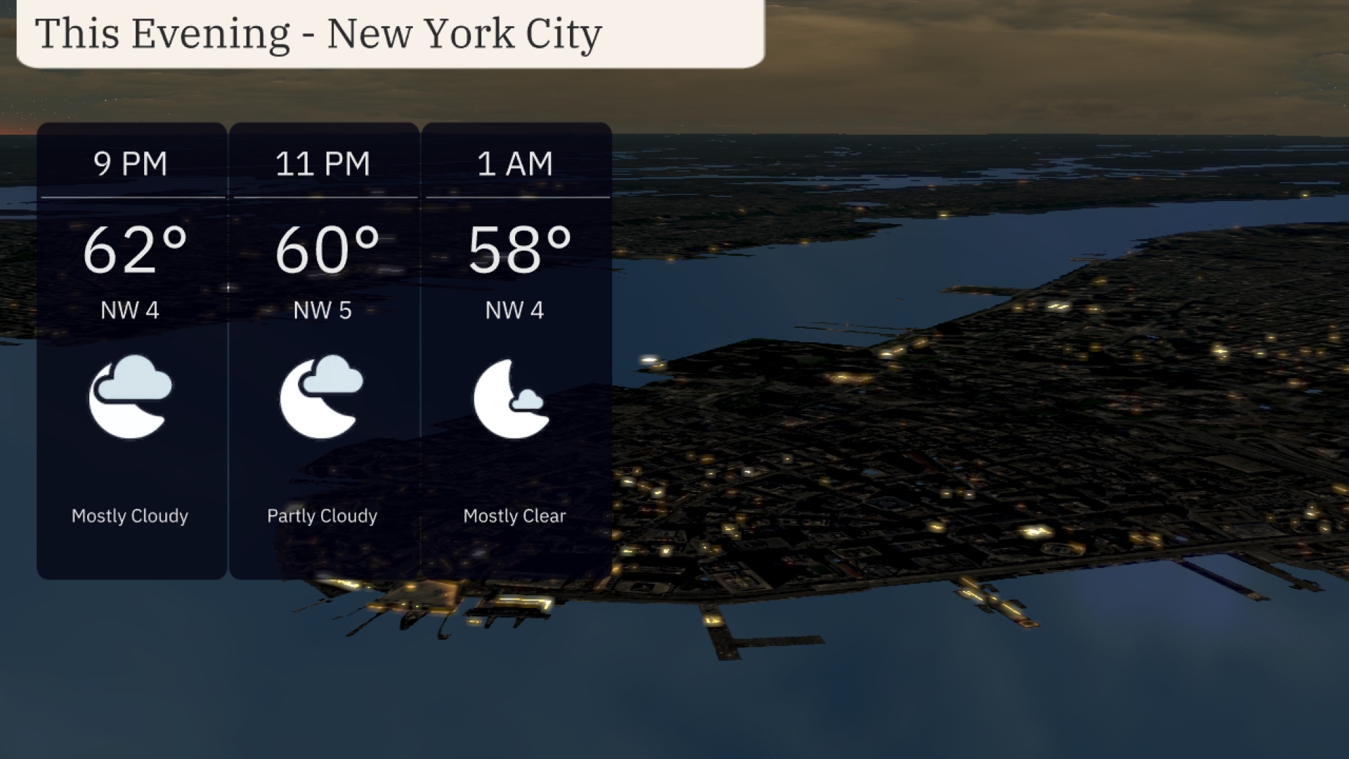
Temperatures in New York City this evening will gradually decrease from 62 degrees at 9 PM to 58 degrees by 1 AM. Winds will be coming from the northwest at 4 to 5 miles per hour. Skies will be mostly cloudy early on, clearing slightly as the night progresses. Expect a calm and cool evening under mostly clear skies by 1 AM.
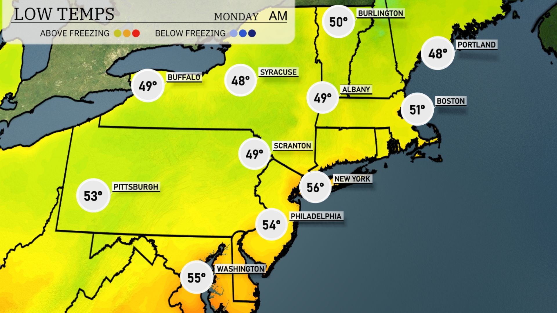
Tonight Buffalo and Syracuse are expected to drop to 49 and 48 degrees, respectively. New York City will see a low of 56 degrees, while Philadelphia will settle at 54 degrees. Pittsburgh will cool down to 53 degrees, and Boston is forecasted to hit 51 degrees. Scranton will also see a low of 49 degrees, establishing a chilly night across the region.
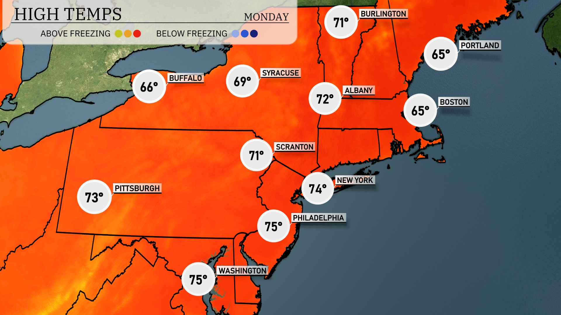
Tomorrow New York City is set to reach a pleasant 74 degrees, while Philadelphia will be even warmer at 75 degrees. Scranton is looking at a comfortable 71 degrees, and Pittsburgh will enjoy 73 degrees. The trend indicates a nice warm-up for early summer with Boston and Portland slightly cooler, both topping out at 65 degrees.
Expect periods of rain in the Northeast tomorrow, with heavier showers near Albany and light rain extending to New York City by evening. Temperatures will remain cool, holding in the mid 50s to low 60s Fahrenheit. The rain is forecasted to clear by late evening, providing relief to areas experiencing ice and mixed precipitation along the northern parts. A low-pressure system over the region is set to move out, bringing drier conditions into Sunday.
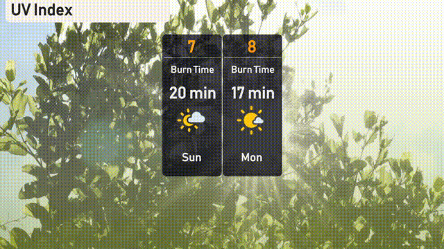
The UV index in New York City on Sunday will be high at 7, with a burn time of about 20 minutes. Prepare for Monday as the UV index rises to 8, meaning a quicker burn time of just 17 minutes!
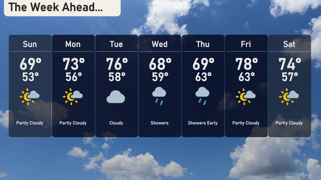
Sunday: Start with partly cloudy skies and a comfortable high of 69 degrees, dropping to 53 degrees at night.
Monday: Enjoy mostly sunny conditions and a warmer day with a high of 73 degrees and a low of 56 degrees.
Tuesday: Cloudy conditions move in with cooler temperatures reaching a high of 76 degrees and a low of 58 degrees.
Wednesday: Showers make their appearance, with the high at 68 degrees during the day and cooling down to 59 degrees overnight.
Thursday: Expect showers early in the day with a high of 69 degrees and a low of 63 degrees.
Friday: Partly cloudy skies return, and temperatures rise to a pleasant 78 degrees, cooling to 63 degrees at night.
Saturday: Partly cloudy again with a high of 74 degrees and a low of 57 degrees.