NYC Nights: Crisp Evenings and Sizzling Days Ahead!
By
Amy Freeze
Experience the dynamic weather of NYC! From tranquil evenings to sizzling daytime highs, know what to expect right outside your front door.
Tonight in NYC, enjoy calm weather with declining temperatures making it perfect for an evening out. With a detailed look at the weekly forecast and special alerts for upcoming storms, stay informed and prepared!
This week in NYC and the Northeast promises a rollercoaster of temperatures and conditions. Starting with calm, clear skies tonight and escalating to warmer days, expect diverse conditions. Midweek brings a cold front with potential thunderstorms and heavy rain. Your comprehensive guide to understanding and navigating the varied weather in your area is here. Detailed tips on safety and preparedness are included to help you weather any storm!
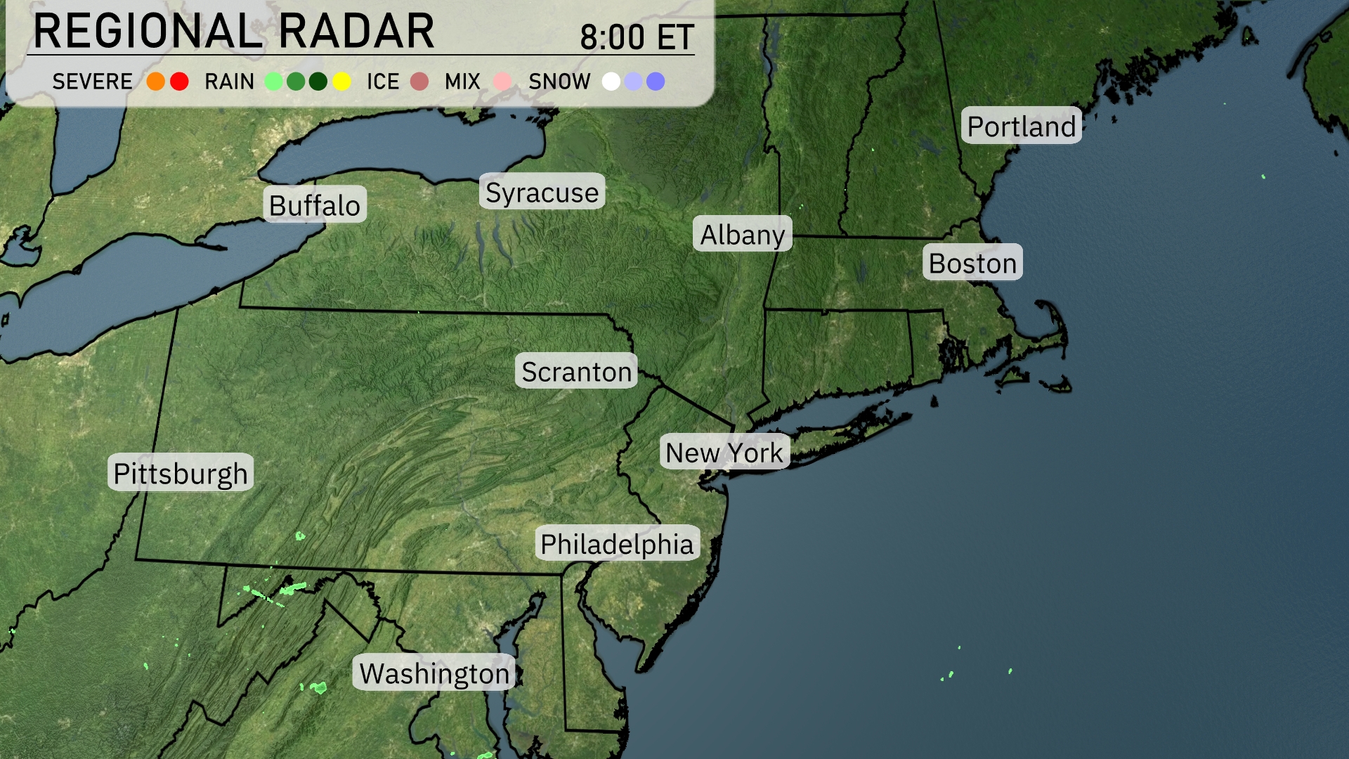
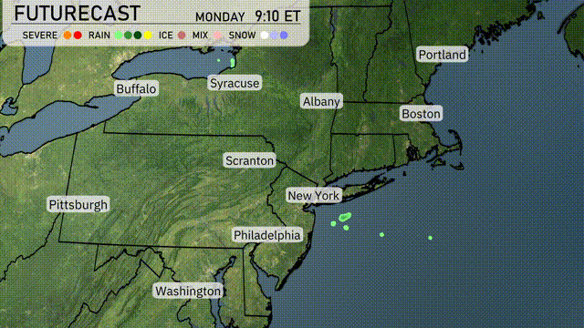
The Northeast region is experiencing generally clear conditions, with no significant precipitation across cities like Boston, Albany, and Syracuse. Some light rain showers are developing near the Washington area, extending slightly towards Pittsburgh. Buffalo and Scranton remain dry under clear skies.
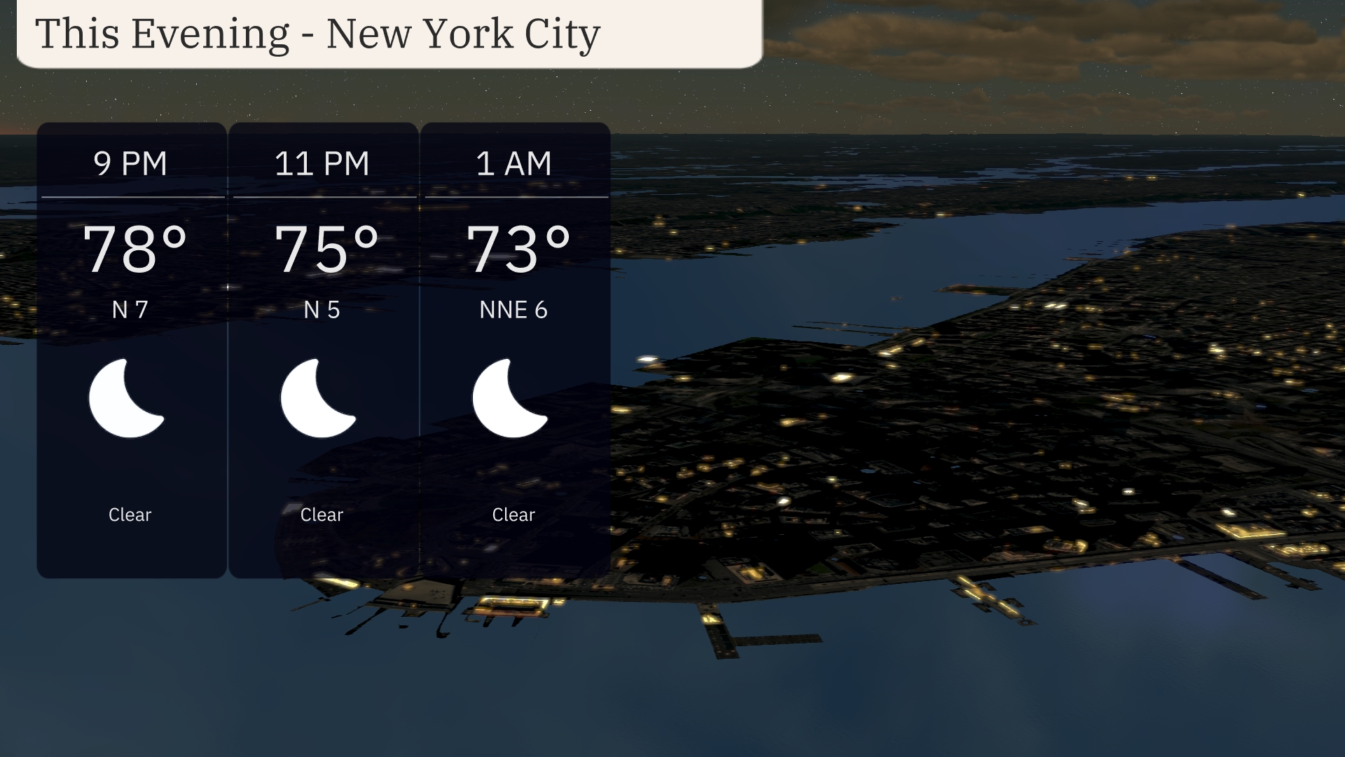
For the evening in New York City, expect clear skies with temperatures gradually decreasing from 78 degrees at 9 PM to 73 degrees by 1 AM. Winds will be calm, coming from the north at 7 mph, then easing to 5 mph from the north, and finally settling at 6 mph from the north-northeast. It’s a tranquil evening, perfect for outdoor activities with pleasant night-time temperatures.
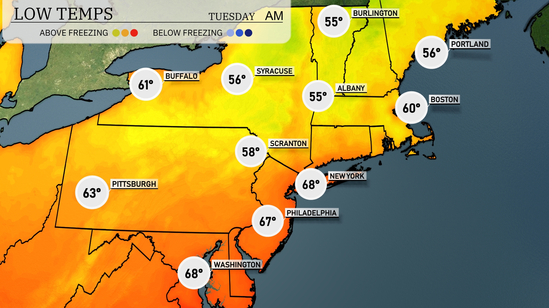
Tonight, temperatures will dip to 55 degrees in Syracuse and Albany, while Boston is expected to drop to 60. New York City will see a low of 68 degrees, remaining relatively mild. Scranton will cool to 58 degrees, and Pittsburgh will register at 63.
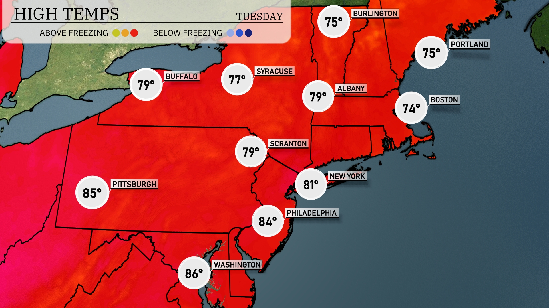
Tomorrow in the Northeast, temperatures will climb into the upper 70s and 80s. New York City is poised for a high of 81 degrees, while Philadelphia could reach around 84. Pittsburgh is expected to warm up to a sweltering 85 degrees, indicating a warmer trend across the region. Boston will be slightly cooler at 74 degrees, and Buffalo will see highs around 79.
A cold front is set to move through the Northeast, starting late tonight, bringing with it a band of rain and thunderstorms. Areas from Boston to Syracuse could experience strong winds and heavy downpours, lasting through Tuesday morning. Temperatures will dip slightly behind the front with cooler high temperatures reaching the mid-70s. Flash flooding is a concern, especially in low-lying areas as rainfall totals could exceed one inch in some spots. As the front sweeps through, expect drier conditions by Wednesday, though some lingering showers may persist along coastal areas.
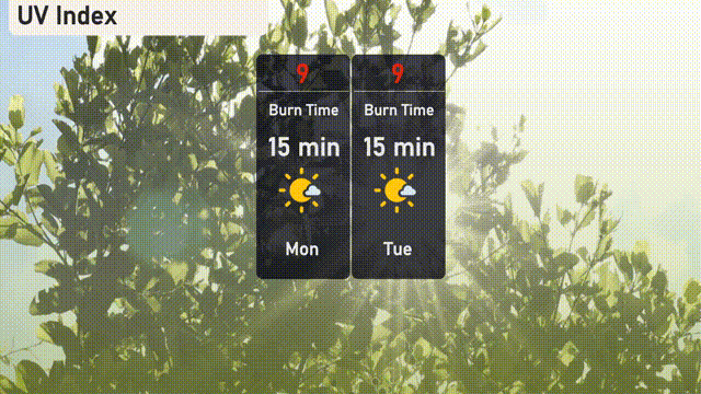
Expect a very high UV index in New York City at 9 on both Monday and Tuesday, with a quick burn time of just 15 minutes in direct sunlight. It’s crucial to minimize your time in the sun during peak hours and don’t forget that sunscreen!
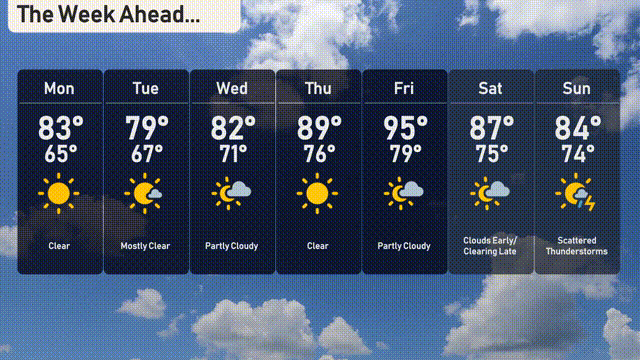
Monday: Clear skies with a comfortable high of 83 degrees and a low of 65 degrees.
Tuesday: Mostly clear with temperatures peaking at 79 degrees and dropping to 67 degrees overnight.
Wednesday: Prepare for a partly cloudy day with a high of 82 degrees and a low of 71 degrees.
Thursday: Enjoy another partly cloudy day as temperatures climb to a high of 89 degrees, with a low of 76 degrees.
Friday: A sunny day ahead with a high temperature of 95 degrees and a low of 79 degrees.
Saturday: Clouds early in the day, but clearing late. Expect a high of 87 degrees and a low of 75 degrees.
Sunday: Scattered thunderstorms are in the forecast, with a high of 84 degrees and a low of 74 degrees.