Experience the ebb and flow of New York City's weather from evening tranquility to stormy shifts. Get ready for a week filled with varying skies and temperatures.
Tonight, NYC welcomes you with mostly cloudy skies and whispers of thunder—a prelude to a week of temperature swings and scattered showers. Read our detailed blog post for a deeper dive into what’s coming.
As the city lights flicker beneath the partially cloudy skyline, New York City’s evening unfolds with a blend of tranquility and anticipation. Scattered rains in Boston and clear spells in Philadelphia add to the complexity of the Northeast’s weather narrative. With temperatures gradually falling throughout the night and potential thunderstorms, our comprehensive blog provides a detailed forecast to keep you well-prepared. Follow along as we explore temperature trends, storm conditions, and safety tips for the week ahead.
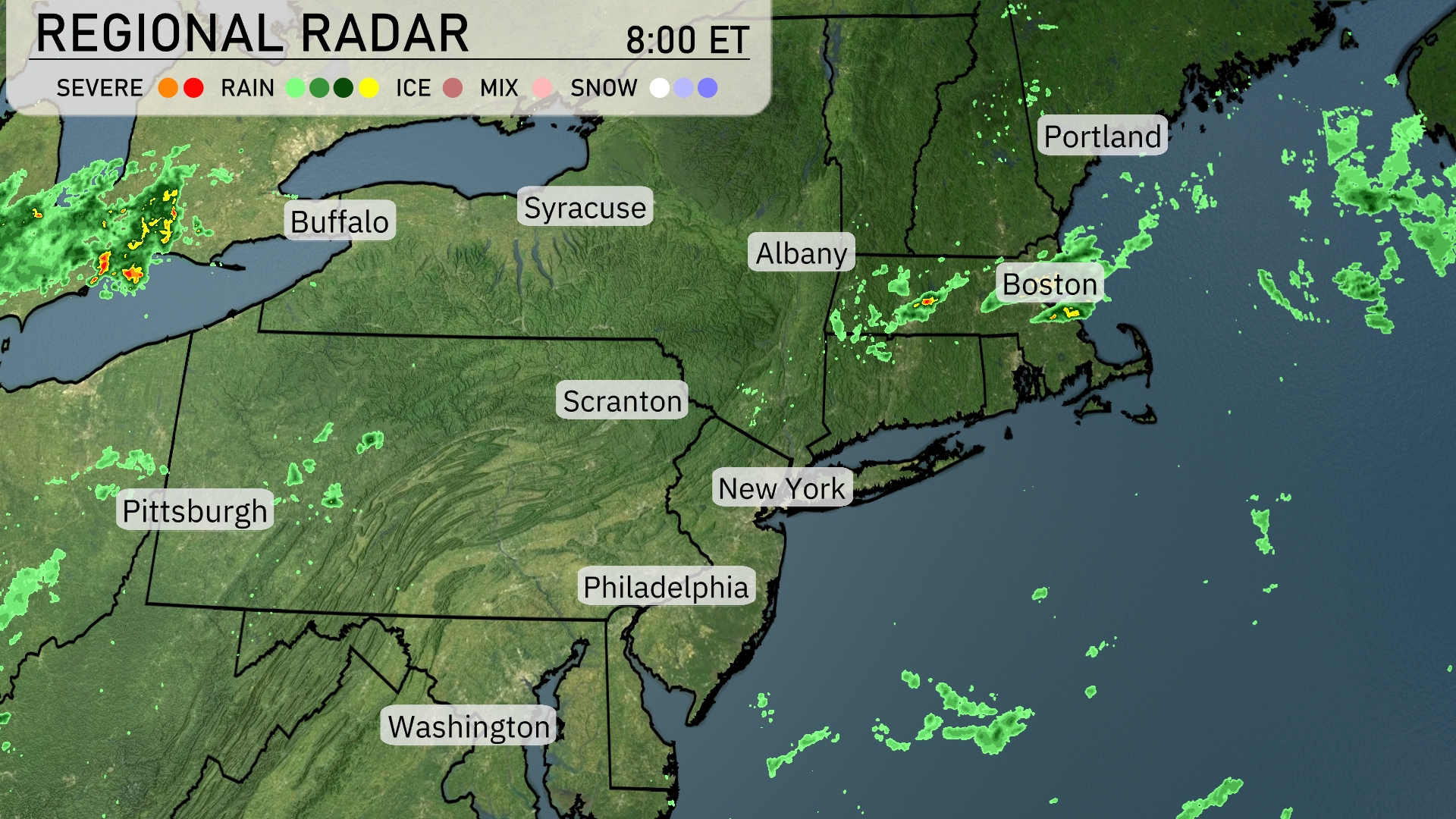
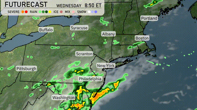
The Northeast is experiencing scattered precipitation, particularly around Boston where showers are moving through the area. Rain is noted near Portland, Maine, hinting at wet conditions as it spreads. Parts of New York and Philadelphia are observing clear skies, creating a dry break from recent weather patterns. Meanwhile, light rain is moving out of the Pittsburgh area, promising relief from cloud cover.
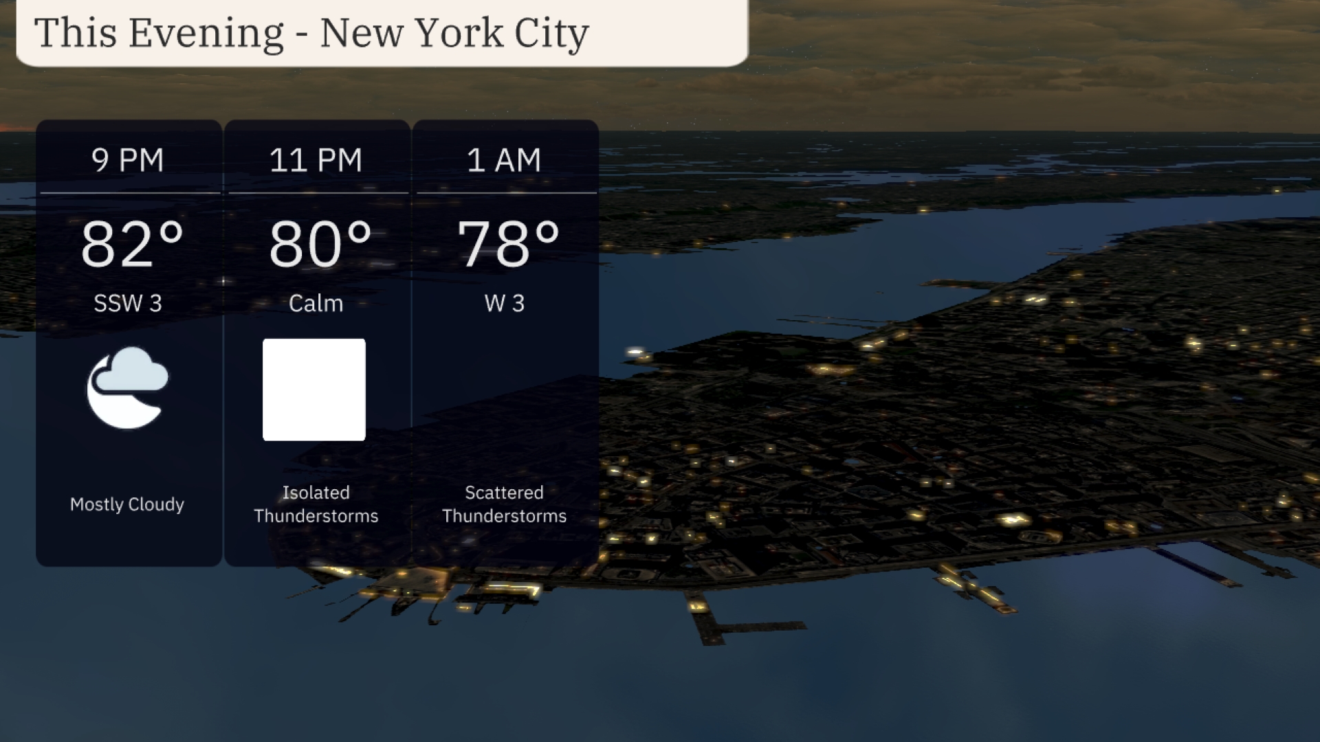
For this evening in New York City, expect mostly cloudy skies with temperatures easing from 82 degrees at 9 PM down to 78 degrees by 1 AM. Winds will be variable, starting south-southwest at 3 mph, becoming calm by 11 PM, then shifting west at 3 mph by early morning. Isolated thunderstorms are possible around 11 PM, with scattered thunderstorms following at 1 AM. Keep an umbrella handy if you’re venturing out.
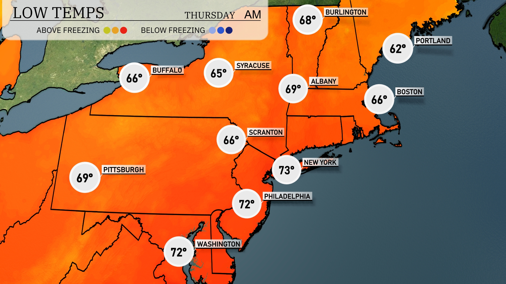
Tonight, Boston will drop to a low of 66 degrees, while Portland lingers at 62. New York is expected to register a mild 73 degrees, with Philadelphia not far behind at 72. Scranton will cool down to 66 degrees, and Buffalo will be slightly warmer at 69.
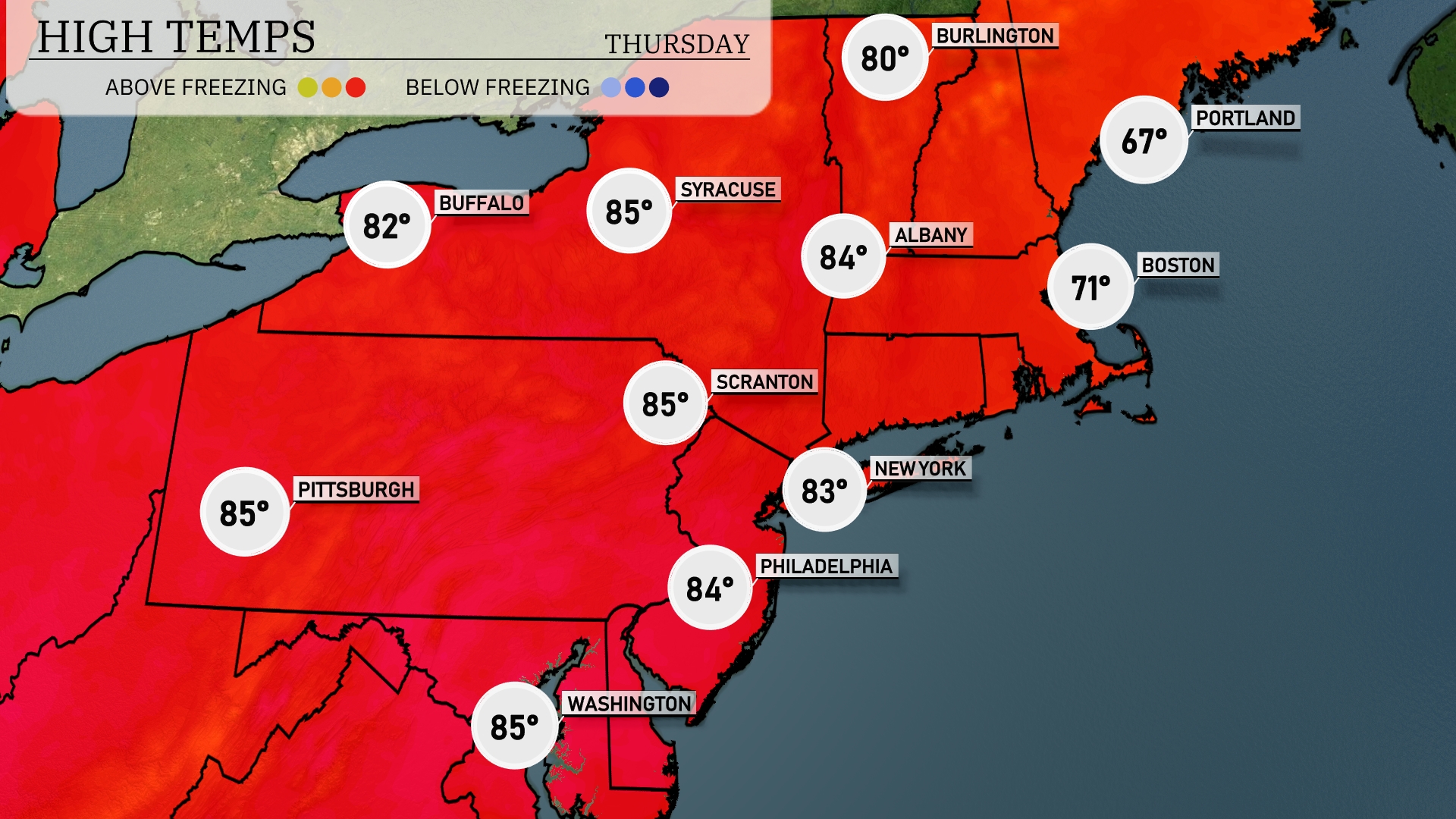
Tomorrow in the Northeast, expect a warm day with high temperatures reaching into the mid-80s. Pittsburgh and Scranton will both hit 85 degrees, while Syracuse is just a degree behind at 84. Philadelphia forecasts a high of 84 degrees, and New York City will warm up to 83 degrees. Notably, Boston will see milder temperatures at 71 degrees, and Portland, Maine, remains cooler at 67 degrees. Overall, most areas are experiencing above-average temperatures for this time of year, influenced by a warm air mass settling over the region.
Tomorrow, the Northeast will experience a dynamic weather shift with rain extending from Philadelphia to New York City by morning, intensifying as it moves north. Expect heavy showers with potential for flash flooding, especially in urban areas. As the front progresses, gusty winds may accompany the rain, creating hazardous travel conditions. Temperatures will see little change but plan for a wet commute. Keep an eye on storm updates, especially for coastal regions where waves could be higher.
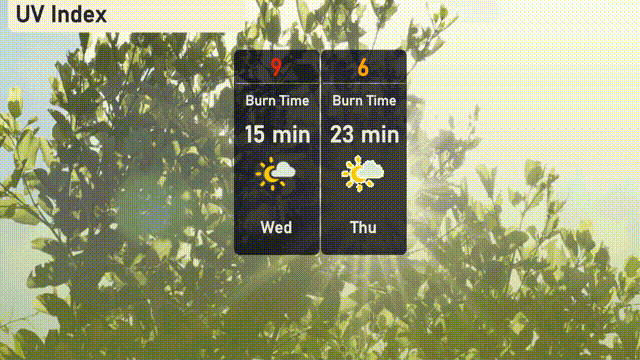
In New York City, the UV index on Wednesday is quite high at 9, with a burn time of just 15 minutes under direct sunlight. By Thursday, the UV index decreases to a moderate level of 6, offering a burn time of 23 minutes. Be sure to protect your skin with sunscreen and protective clothing!
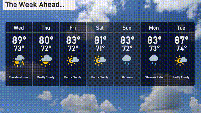
Wednesday: Thunderstorms expected with a high of 89 degrees and a low of 73 degrees.
Thursday: Mostly cloudy skies with a daytime high of 80 degrees and a low temperature of 72 degrees.
Friday: Partly cloudy conditions, reaching a high of 83 degrees and dropping to 72 degrees at night.
Saturday: Pleasantly partly cloudy with temperatures peaking at 81 degrees and a low of 71 degrees.
Sunday: Showers on the horizon with a high reaching 83 degrees and a low of 72 degrees.
Monday: Anticipate showers late in the day with a high of 83 degrees and a nighttime low of 73 degrees.
Tuesday: Partly cloudy, and a bit warmer with a high of 87 degrees and a low of 74 degrees.
Enjoy the week ahead!