Explore the nightly shifts in New York City's weather from partly cloudy to perfectly clear, with a sneak peek at the upcoming week's temperatures and conditions.
This evening in NYC, temperatures cool as skies clear. Dive into our blog for a complete 7-day weather outlook and tips on how to plan your week around the city’s shifting skies.
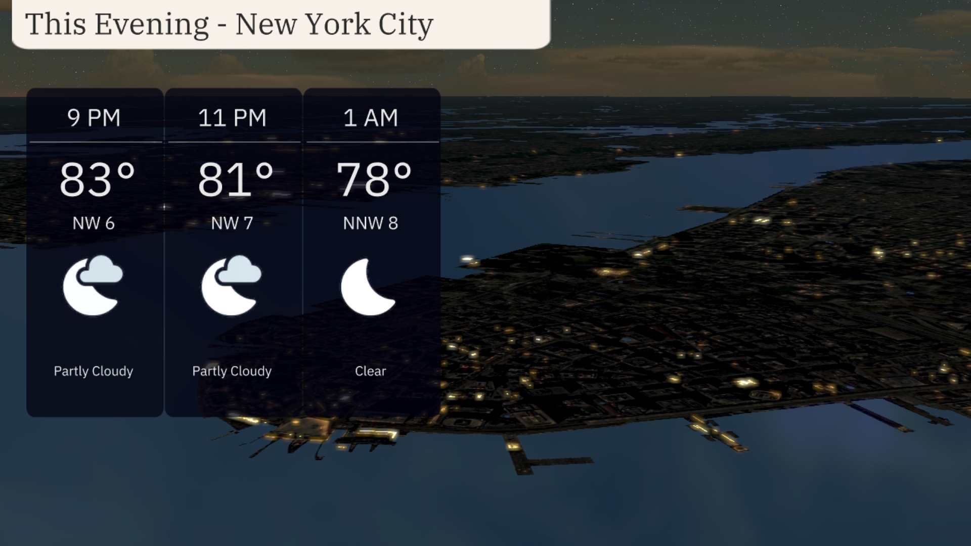
The Big Apple experiences a dynamic weather evening on July 20, 2025, transitioning from partly cloudy to clear skies. With temperatures starting at 83 degrees and cooling down through the night, New York City remains vibrant under the changing skies. There’s a mix of conditions across the Northeast, with scattered showers affecting areas from Philadelphia to Syracuse. Looking ahead, the 7-day forecast promises a mix of thunderstorms and clear skies, with temperatures peaking at 95 degrees by Friday. Get detailed insights and more on our comprehensive blog at https://amyfreeze.ai/.
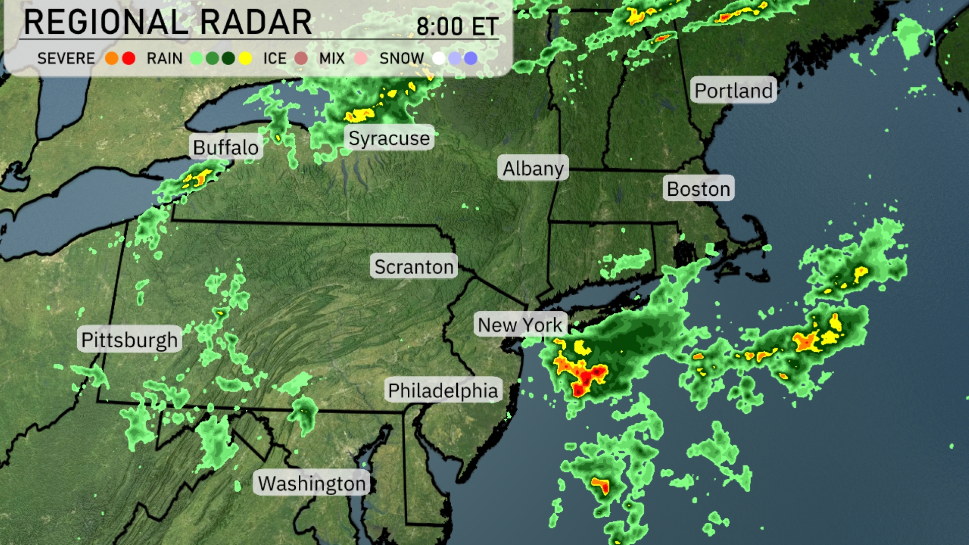
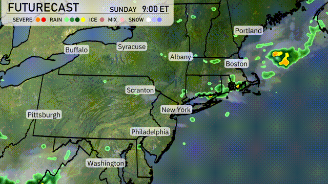
The Northeast is seeing a mix of weather conditions on the radar with scattered showers and storms. New York City is experiencing heavy rain moving offshore, while Philadelphia is seeing lighter showers. Scranton and Syracuse are dealing with patches of rain making their way eastward. Portland remains dry, but cloud cover is increasing as the system moves in from the south.
For this evening in New York City, temperatures will start around 83 degrees at 9 PM, cooling to 81 degrees by 11 PM, and reaching 78 degrees by 1 AM. Expect a partly cloudy sky initially, transitioning to clear conditions later in the night. Winds will be from the northwest, starting at 6 miles per hour and increasing slightly to 8 miles per hour.
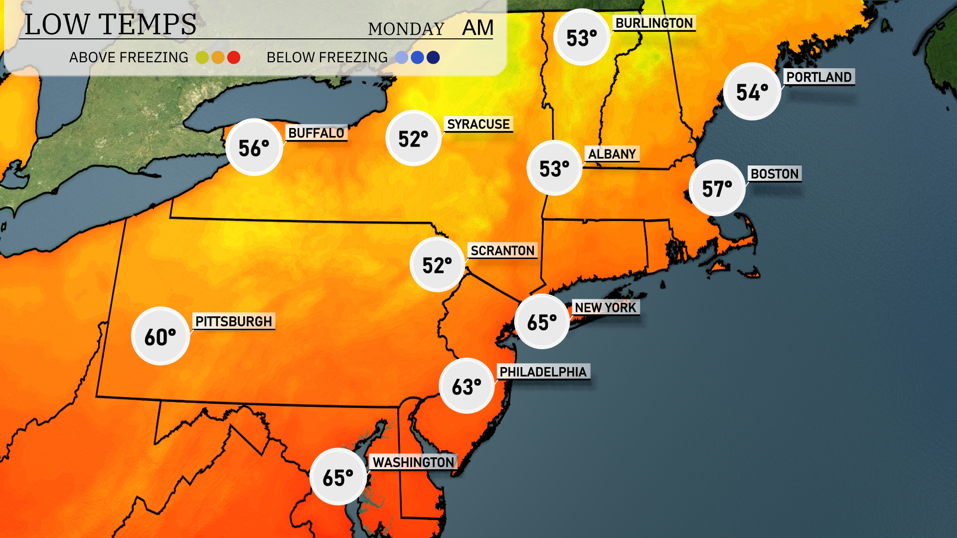
Tonight, Boston will see a low of 57 degrees, while New York City drops to 65. Philadelphia will cool down to 63 degrees, with Scranton at a cooler 52 degrees. Syracuse is expected to reach 52, and Buffalo will finish the night at 56 degrees.
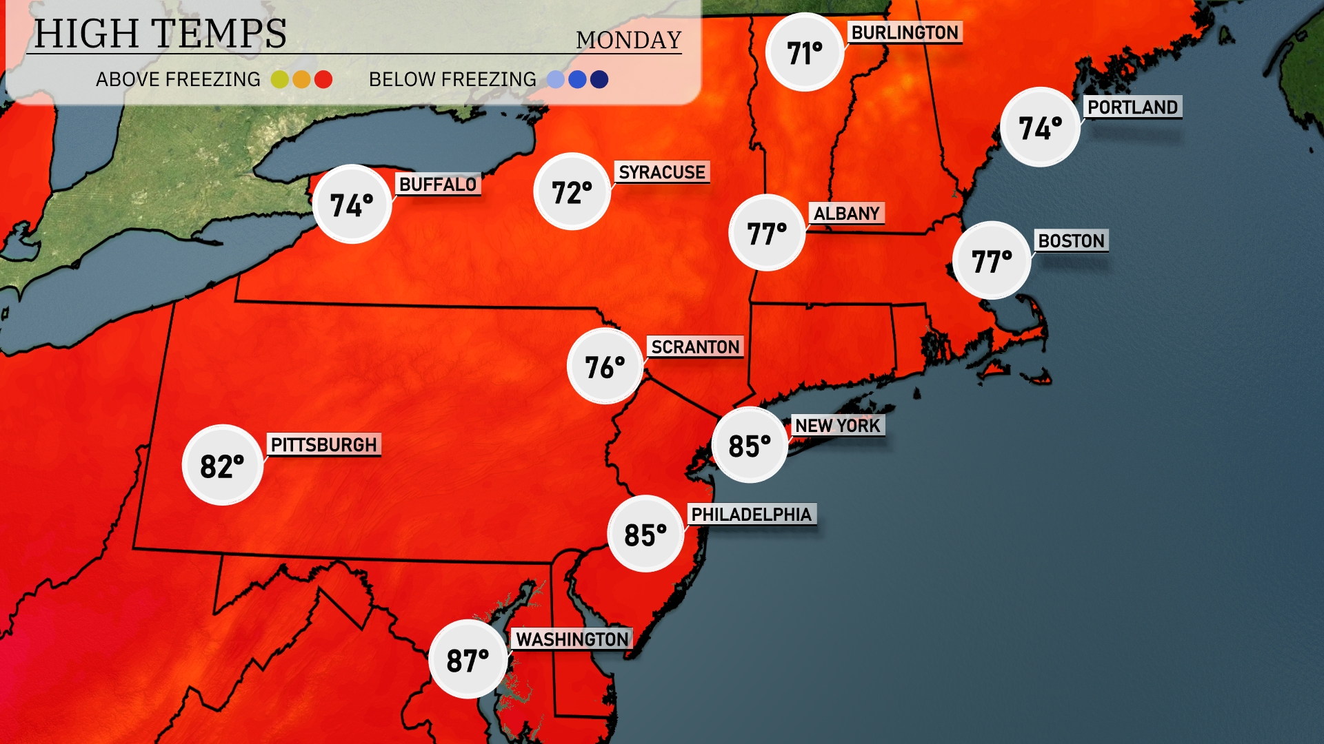
Tomorrow in the Northeast, expect a warm day with temperatures reaching 87 degrees in Washington, D.C. Philadelphia and New York will both see highs at 85 degrees, making it a notably warm day. Scranton will be a bit cooler at 76 degrees, while Buffalo will hit 74. Notably, these temperatures are well above the seasonal averages, driven by a high-pressure system just to the west. The warming trend continues into the midweek, with no major weather disturbances expected.
A cold front sweeps through the Northeast tomorrow, bringing scattered showers and potentially strong thunderstorms from Albany to Boston. Coastal areas near Boston may experience heavy downpours, with localized flooding possible. Temperatures will hover around the mid to upper 70s, dipping slightly post-frontal passage. Syracuse and Scranton could see intermittent rain, with skies clearing by late evening. Keep an umbrella handy as the weather remains unpredictable throughout the day.
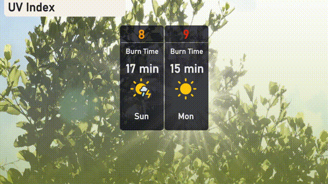
Heads up for New Yorkers! The UV index is high at 8 today, with a burn time of just 17 minutes in direct sunlight. Tomorrow, it climbs to a very high 9, reducing the burn time to 15 minutes.
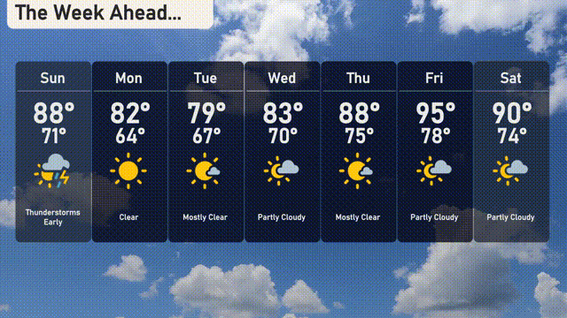
For the 7-day outlook in New York City:
Sunday: Thunderstorms early with highs around 88 degrees and a low of 71 degrees.
Monday: Clear skies throughout the day, temperatures peaking at 82 degrees, dropping to 64 degrees at night.
Tuesday: Mostly clear with daytime temperatures reaching 79 degrees and a cooler night at 67 degrees.
Wednesday: Partly cloudy with a high of 83 degrees and lows around 70 degrees.
Thursday: Mostly clear skies with a warming trend, highs reaching 88 degrees and 75 degrees overnight.
Friday: Mostly cloudy, expect temperatures to soar to 95 degrees during the day, cooling slightly to 78 degrees.
Saturday: Partly cloudy skies with a daytime high of 90 degrees and an overnight low of 74 degrees.
Enjoy the week ahead!