NYC Evening Weather Update: A Swath of Showers and a Glimpse of Tomorrow’s Sun
By
Amy Freeze
Explore the latest weather updates across the Northeast, from the rainy reaches of NYC to the clear skies above Boston. Get ready for a mix of clouds, sun, and possible thunderstorms.
Tonight’s weather in NYC brings partly cloudy skies with temperatures holding steady. A cold front on its way promises more action with possible thunderstorms and mild temperatures.
This blog post offers an in-depth analysis of the prevailing weather conditions sweeping through New York City and the wider Northeast region. From the cool breezes of the evening to the thunderous warnings of an impending cold front, we discuss how these elements will affect local and regional weather patterns. Detailed forecasts for each day of the week provide a comprehensive guide to help you plan ahead comfortably and safely.
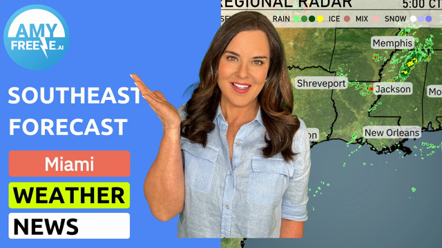
A swath of rain is sweeping through the Northeast from Pittsburgh, moving across central Pennsylvania into Scranton and New York City. Philadelphia and Washington D.C. are experiencing scattered showers, indicating wet conditions. Areas like Boston and Portland remain under clearer skies with no significant precipitation detected. Keep an eye on the expanding rain pattern as it pushes northeastward, affecting more regions throughout the day.
Expect a cloudy evening in New York City with temperatures starting at 66 degrees at 9 PM and slightly tapering to 65 degrees by 11 PM and staying consistent through 1 AM. Winds will be gentle from the northeast at 5 miles per hour, decreasing to 4 miles per hour closer to midnight. The cloud cover will continue throughout the night, providing a consistent, overcast sky.
Tonight, Boston will see a low of 59 degrees, while Providence will drop to 61. New York City expects to cool down to 66 degrees, and Philadelphia is looking at a low of 68. Scranton will also register 66 degrees, maintaining a steady night across the Northeast with no significant cold air patterns expected.
Tomorrow, high temperatures across the Northeast will be notably warm, with Buffalo reaching 80 degrees, well above average for this time of year. Pittsburgh will see a high of 79 degrees, while Philadelphia is expected to hit 76 degrees. New York City and Scranton will both settle around 71 degrees. Boston will experience a cooler day with a high of 69 degrees, and Portland will be even chillier at 66 degrees.
A cold front moves through the Northeast tomorrow, bringing scattered showers and possible thunderstorms across areas including Philadelphia and New York. By mid-day, expect rainfall to extend into Boston and Syracuse, with some storms potentially becoming severe. Heavy rain could lead to localized flooding, so be cautious on the roads. Temperatures will remain mild during the day but will cool significantly as the front passes.
The UV index in New York City is moderate at 4 for today, with a burn time around 35 minutes under direct sunlight.
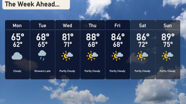
Monday: Cloudy skies with a high reaching 65 degrees and a low of 62 degrees.
Tuesday: Showers expected late in the day, with a high of 68 degrees and a low of 65 degrees.
Wednesday: Partly cloudy with warmer conditions, rising to a high of 81 degrees and a low of 71 degrees.
Thursday: Another partly cloudy day, as temperatures peak at 88 degrees and dip to 68 degrees at night.
Friday: Mostly sunny with a high of 84 degrees and a nighttime low around 68 degrees.
Saturday: Enjoy partly cloudy skies and a high of 86 degrees, with lows at 72 degrees.
Sunday: Partly cloudy and warming up further, topping out at 89 degrees with a low of 75 degrees.