Explore how NYC's extreme temperatures shift from scorching heat to stormy evenings. What's behind this volatile weather? Get our full weekly forecast.
NYC reels under a severe heat warning with temperatures soaring above 100 degrees. As the city grapples with this extreme weather, get ready for a dramatic shift with incoming storms.
New York City is experiencing unprecedented high temperatures this week, with records hitting the 103-degree mark. As residents seek respite from the blaring sun, evening forecasts predict a shift towards cooler and stormier conditions. From local temperature hikes and UV warnings to storm preparation and safety tips, find everything you need to know about this week’s severe weather conditions on our detailed blog post.
It’s hot with not relief from the heat. Skies are clear across much of the Northeast, with no significant precipitation visible. However, a small area of rain is detected off the coast, southeast of Boston. Cities like Buffalo, Syracuse, and Albany remain hot and dry. Expect similar conditions across New York City and Philadelphia, with no immediate signs of rain or storms.
Afternoon temperatures in New York City are sizzling, reaching up to 101 degrees by 4 PM. Winds from the west-northwest remain light, between 6 and 7 miles per hour, providing little relief from the heat. Expect clear skies with plenty of sunshine throughout the afternoon. As the evening approaches, temperatures will gradually decrease to 93 degrees by 8 PM.
This afternoon, high temperatures in the Northeast are soaring. New York City will see a blistering 103 degrees, while Philadelphia is close behind at 101. In Scranton, it’s a hot 97 degrees, and further north, Albany reaches 98. Buffalo will enjoy a milder 83 degrees, providing a stark contrast to the sweltering heat further south.
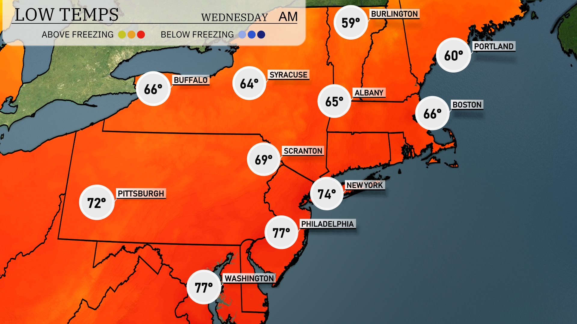
Tonight in the Northeast, expect low temperatures to dip to 59 degrees in Burlington. Albany will see a low of 65, while Scranton is forecasted to drop to 69. In New York City, temperatures will cool to 74. Boston will experience a low of 66 degrees.
Tomorrow in the Northeast, we’re seeing some impressive highs as a heatwave unfolds. New York City will reach a blistering 97 degrees, while Philadelphia paces ahead at 98 degrees, both well above average for this time of year. In Boston, expect a warm 91 degrees, and Albany will see a high of 90. Pittsburgh can anticipate a high of 92 degrees, contributing to the overall heat across the region. This warm spell is influenced by a dominating high-pressure system leading to clear skies and unseasonably high temperatures.
A warm front will move across the Northeast, leading to mild conditions along with scattered showers in areas like Pittsburgh and Buffalo by mid-afternoon. Expect a line of thunderstorms developing late tonight, especially affecting areas from Syracuse to Albany, with a chance for gusty winds and heavy rain. By tomorrow, the system progresses eastward, bringing rain showers into New York City and Boston. Watch for possible flooding in localized low areas due to rain accumulation. Cooler air follows with dry, breezy conditions settling in by late Wednesday.
NYC will experience a very high UV index of 9 on both Tuesday and Wednesday, meaning sun exposure can lead to burns within just 15 minutes.