Navigating NYC’s April Showers: Weather Insights for a Clearer Tomorrow
By
Amy Freeze
Dive into our complete analysis of NYC's weather forecast for April 15th, featuring meteorologist Amy Freeze's expert insights—from temperature trends to rain predictions.
Expect a dynamic weather day in NYC tomorrow with temperatures fluctuating and scattered rain showers. Get the full scoop with Amy Freeze’s detailed forecast!
Meteorologist Amy Freeze provides a detailed forecast for NYC on April 15, 2025. The day starts with chilly temperatures and mostly cloudy skies, leading into a damp afternoon with scattered showers. Evenings will see temperatures drop, making for a brisk night. For more in-depth analysis, head over to our detailed blog post.
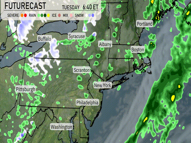
The Northeast is seeing a broad swath of rain stretching from Pittsburgh up through Albany and further into southern Vermont. Scranton to New York City is currently experiencing moderate rain showers, while heavier downpours are positioned just offshore over the Atlantic. In Syracuse, expect periods of light rain with potential breaks. Toward the northern portion of the region, places like Portland are witnessing overcast skies without rain, while Buffalo deals with occasional rain showers. The coastal waters are quite active, with radar indicating intense rainfall offshore.
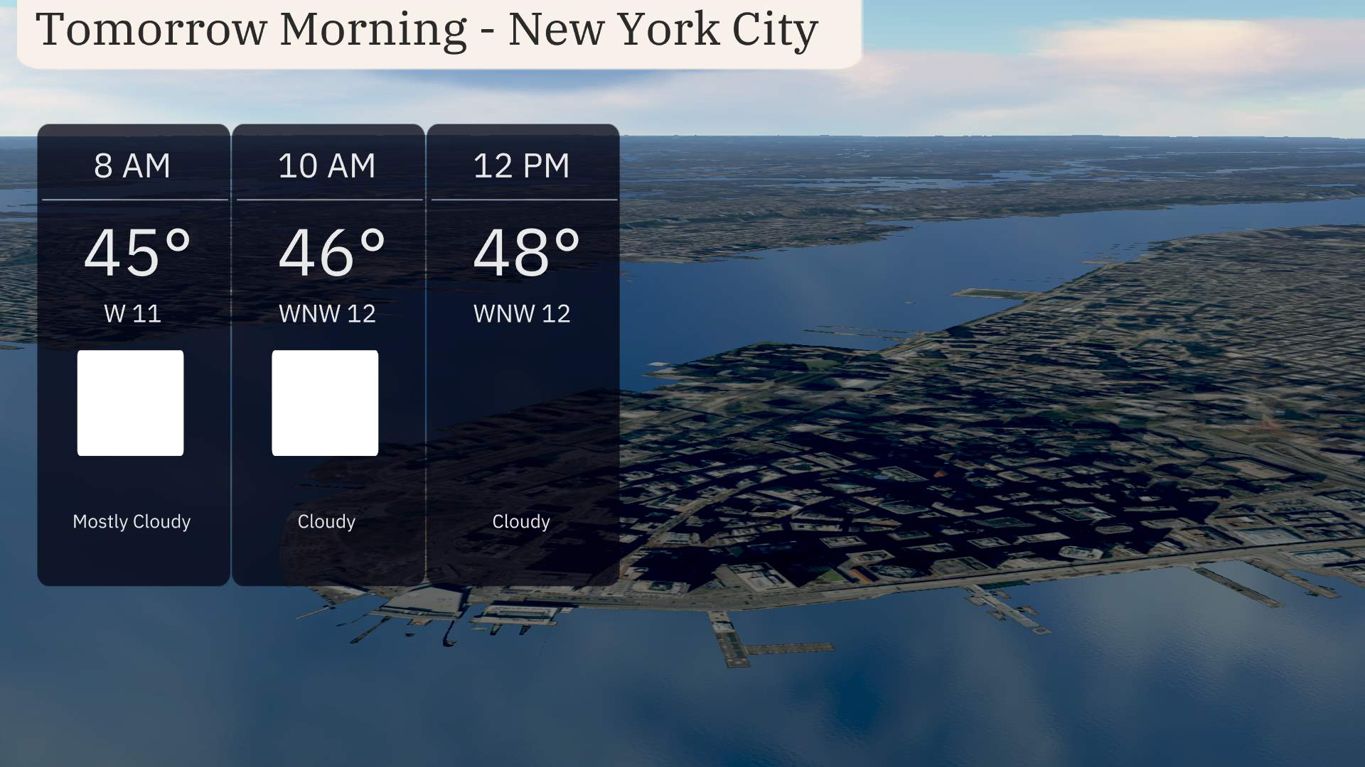
Tomorrow morning in New York City, temperatures start at 45 degrees at 8 AM under mostly cloudy skies. As we move into the late morning, expect a slight temperature rise to 46 degrees at 10 AM and 48 degrees by noon. Winds will be from the west-northwest, ranging between 11 and 12 miles per hour, and skies will remain cloudy throughout the morning.
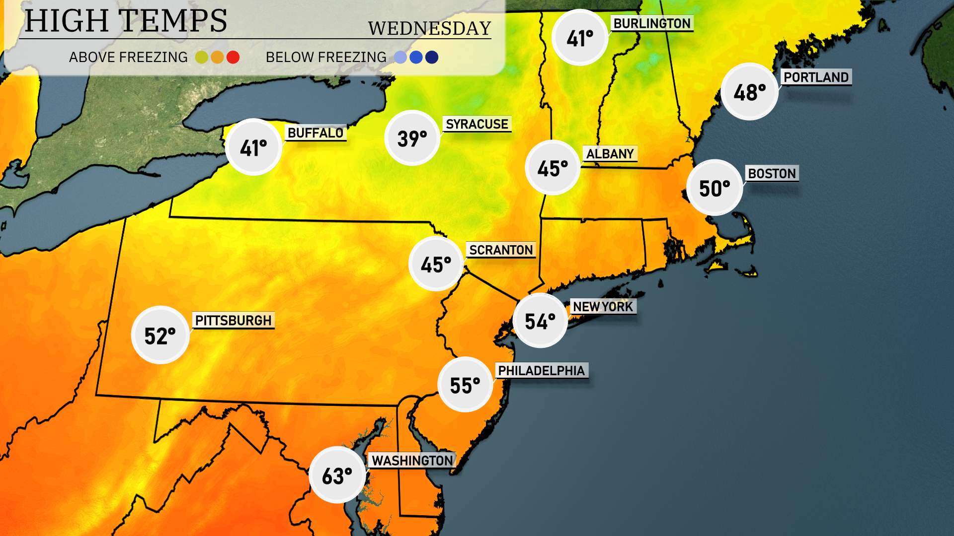
Tomorrow’s high temperatures in the Northeast are expected to be below average as cooler air moves into the region. Boston will reach around 50 degrees, while New York City sees a high of 54 degrees. Philadelphia is slightly warmer at 55 degrees, and Pittsburgh should hit 52 degrees. Scranton and Syracuse are on the cooler side, with highs of 45 and 39 degrees, respectively.
In the Northeast, a cold front pushes through from the west, bringing scattered rain showers to areas from Albany to New York City through the evening. Expect a temperature drop after the frontal passage, with daytime highs cooling into the mid-50s. While severe weather isn’t anticipated, localized heavy rain could briefly impact visibility and make for a wet commute. By tomorrow afternoon, a drying trend takes hold with gradual clearing and cooler air settling in.
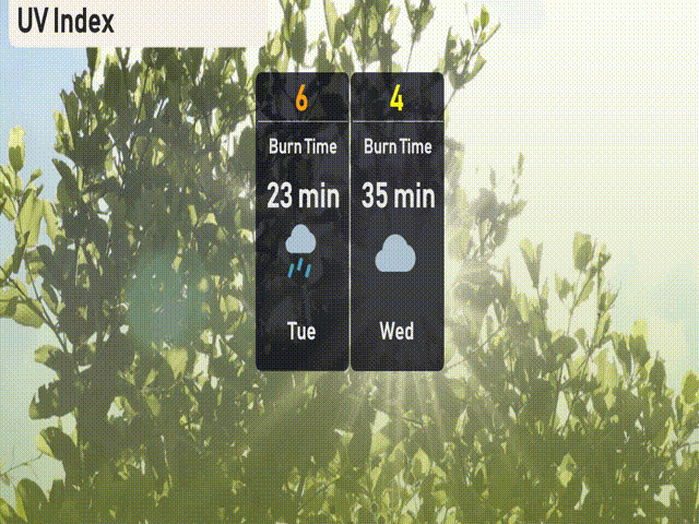
The UV index in New York City today is moderate at 6, with a burn time of approximately 23 minutes in direct sunlight. For tomorrow, the UV index decreases to 4, offering a longer burn time of about 35 minutes. E
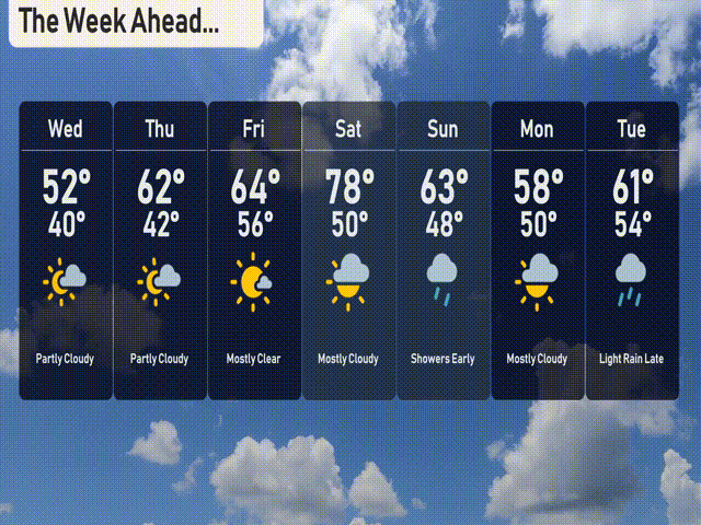
For the 7-day forecast in New York City:
Wednesday: Partly cloudy skies with a high of 52 degrees and a low of 40.
Thursday: Partly cloudy again, temperatures rising to 62 degrees with a 42-degree low.
Friday: Mostly clear and warmer, reaching 64 degrees during the day and cooling to 56 at night.
Saturday: Mostly cloudy but warmer, with a high of 78 degrees and a low of 50.
Sunday: Showers early, with a high of 63 degrees, dipping to 48 overnight.
Monday: More showers possible, as temperatures reach a high of 58 degrees and a low of 50.
Tuesday: Light rain late in the day, with the high around 61 degrees and lows near 54.
Enjoy the week ahead!