Storm Watch: NYC and Northeast Weather Forecast Update
By
Amy Freeze
Dive into the latest weather trends as Amy Freeze gives an anticipated breakdown of the stormy nights and sunny days ahead in NYC and beyond.
Meteorologist Amy Freeze provides an essential update on the evolving storm systems and calm weather patches over NYC and the Northeast. Learn what to expect and how to prepare!
As New York City braces for a shift from clear skies to potential thunderstorms, Meteorologist Amy Freeze offers an in-depth look at the weather patterns affecting the region. Understand the impact of the offshore storm system, the varied temperature profiles across cities, and get prepared for what lies ahead with comprehensive daily and weekly forecasts.
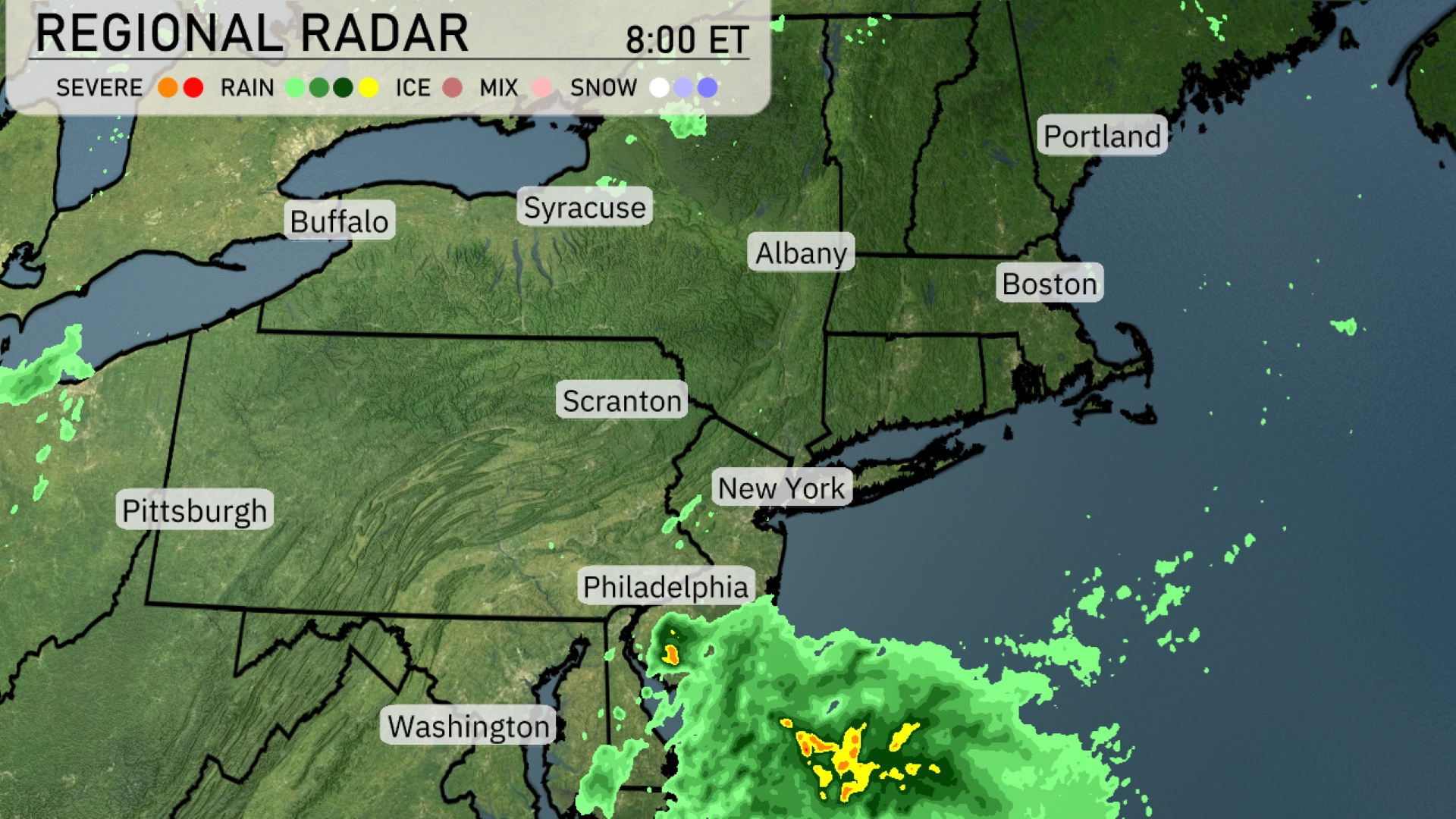
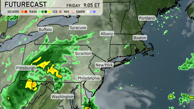
The Regional Radar for the Northeast shows a storm system bringing rain just offshore, with heavier areas poised to impact Philadelphia and moving toward New York City. This weather system might push rain into New Jersey and eastern Pennsylvania as it progresses. Areas further north, such as Syracuse, Albany, and Boston, remain clear and dry for now. Cities like Buffalo and Portland are experiencing calm, stable conditions without any significant precipitation at this moment. Upstate New York and the New England coastline currently enjoy relatively clear skies.
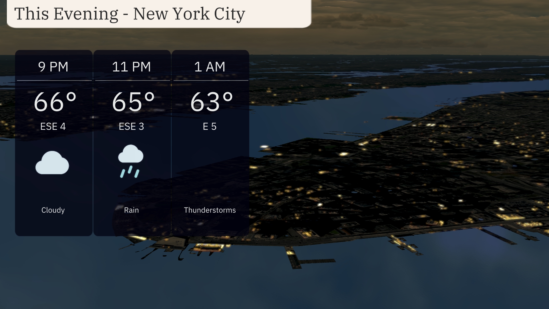
This evening in New York City, temperatures will gradually decrease from 66 degrees at 9 PM to 63 degrees by 1 AM. Expect cloudy skies to start, transitioning to rain by 11 PM, with the possibility of thunderstorms later into the night. Winds will be easing from the east-southeast at 4 mph to 5 mph. Prepare for wet conditions if you’re heading out late tonight.
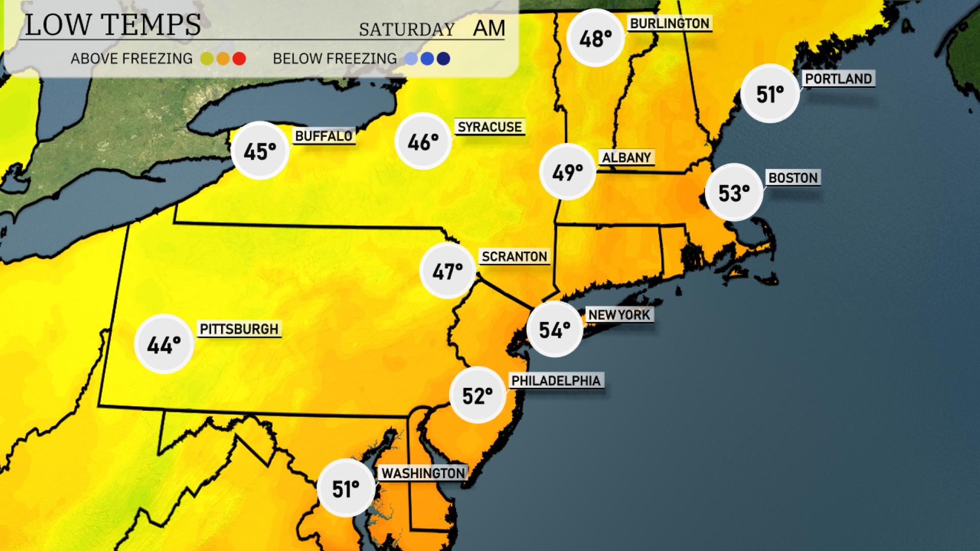
Tonight Pittsburgh will see a low of 44 degrees, while Scranton is slightly warmer at 47. New York City dips to 54, but it’s chilly in Buffalo at 45 degrees. Albany will be cooler with a low of 49, and Boston expects to settle at 53.
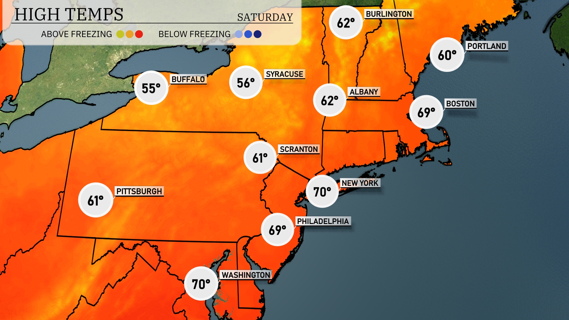
Tomorrow New York City and Washington D.C. will each reach a pleasant 70 degrees, while Philadelphia is close behind at 69. Boston warms up to 69 degrees as well, reflecting a nice spring day. However, Buffalo and Syracuse lag behind with highs of only 55 and 56 degrees, respectively.
A low-pressure system is bringing widespread rain to the Northeast, impacting cities from Philadelphia to Boston. Expect heavy showers throughout the day, particularly in the afternoon and evening, with potential for localized flooding in urban areas. Temperatures will remain cool, hovering in the mid-60s. Winds could pick up as a cold front approaches, with gusts potentially reaching 20-30 miles per hour by tomorrow evening. Keep an eye on the forecast as this system could lead to disruptions during the evening commute.
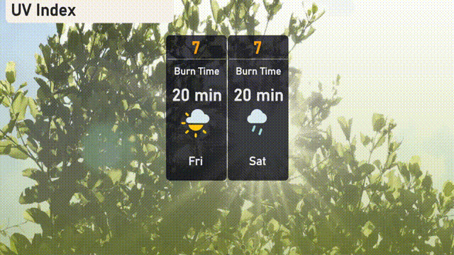
The UV index in New York City will be high on Friday and Saturday, both scoring a level of 7, with a burn time of about 20 minutes in direct sunlight.
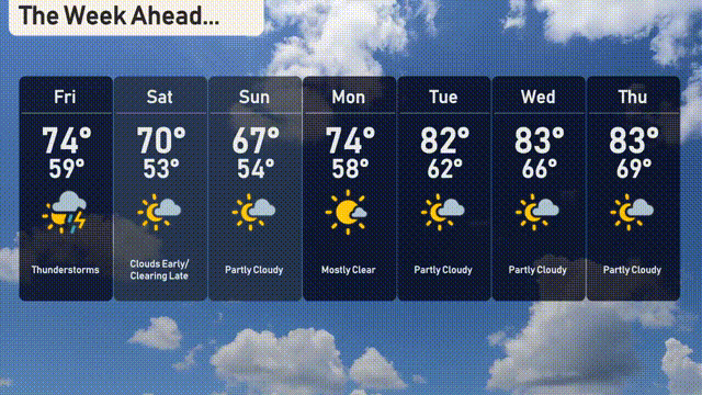
For the 7-day forecast in New York City:
Friday: Thunderstorms are expected with a high of 74 degrees and a low of 59.
Saturday: Clouds early, but they’ll clear later, with a high of 70 degrees and a chillier low of 53.
Sunday: Look forward to partly cloudy skies with a daytime high of 67 degrees, cooling down to 54 degrees at night.
Monday: Mostly clear skies will greet you with temperatures reaching a high of 74 degrees, dipping to 58 overnight.
Tuesday: Partly cloudy conditions continue with the mercury climbing to 82 degrees, while nighttime sees a low of 62.
Wednesday: Enjoy a partly cloudy day with a high of 83 degrees and a low of 66.
Thursday: Continued partly cloudy skies, with temperatures peaking at 83 degrees during the day and dropping to 69 at night.