From Serene Evenings to Stormy Delights: Northeast’s Weather Extravaganza
By
Amy Freeze
Experience the dynamic shifts in weather patterns across the Northeast as Meteorologist Amy Freeze walks you through what to expect from serene evening strolls to unexpected stormy commutes.
Meteorologist Amy Freeze brings you the latest weather updates for NYC and the Northeast. From clear skies today to snow and storms tomorrow, stay updated with our comprehensive weather guide at https://amyfreeze.ai/
Dive deep into the meteorological dynamics affecting NYC and the Northeast with Meteorologist Amy Freeze. This detailed post covers everything from today’s clear conditions to the looming storms and snow. Understand the implications of these changes on your week ahead and how to prepare effectively. Full story and more updates available at https://amyfreeze.ai/
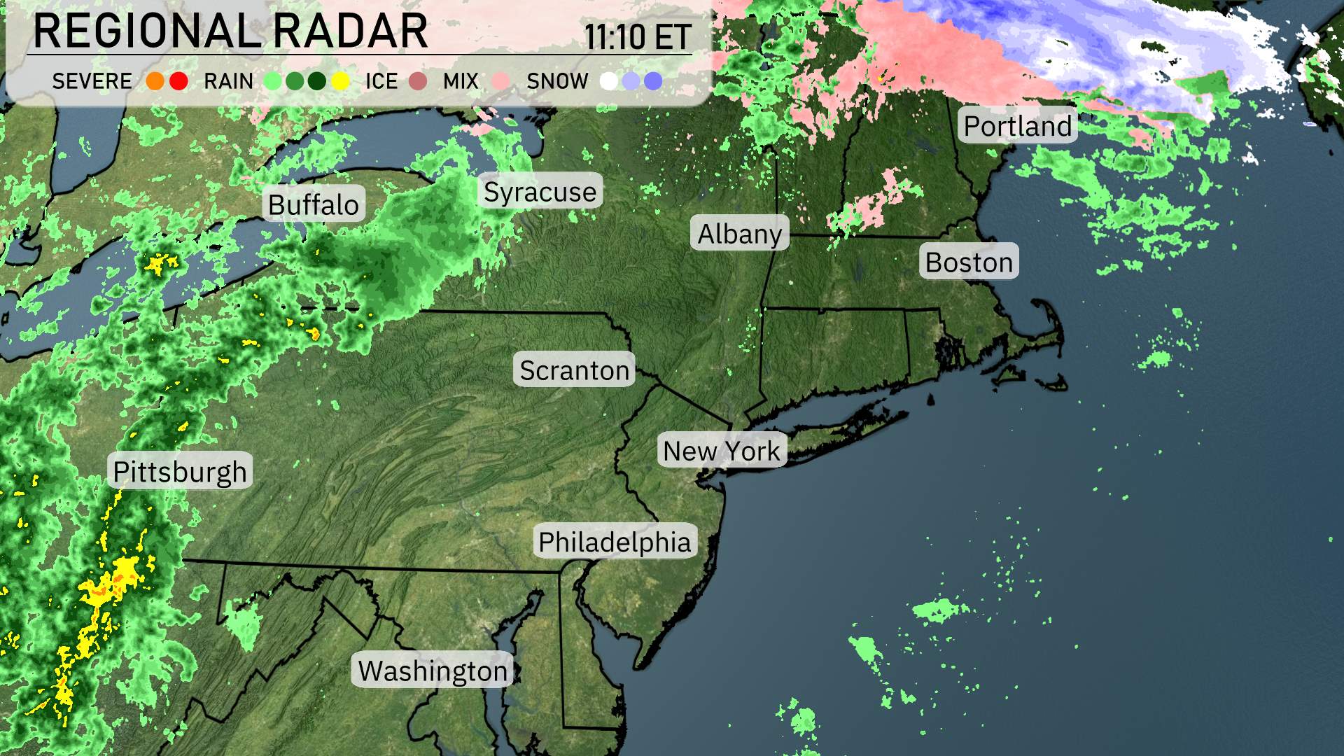
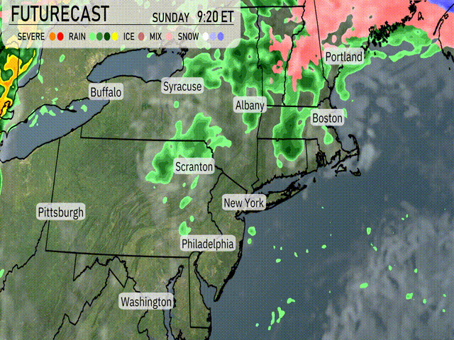
In the Northeast, the regional radar shows a varied weather picture. New York and Boston are under mostly cloudy skies but remain dry at the moment. The rest of the Mid-Atlantic, including Philadelphia and Over western New York, including Syracuse and Buffalo, expect scattered showers extending into northern Pennsylvania near Scranton. These rain bands are moving eastward. Farther north, snow is falling over the higher terrains of northern New England, particularly affecting areas around Albany and stretching into Vermont and New Hampshire. Portland, Maine, is experiencing a wintry mix, indicating a challenging commute with icy conditions. Washington, is enjoying clearer conditions with breaks in the clouds.
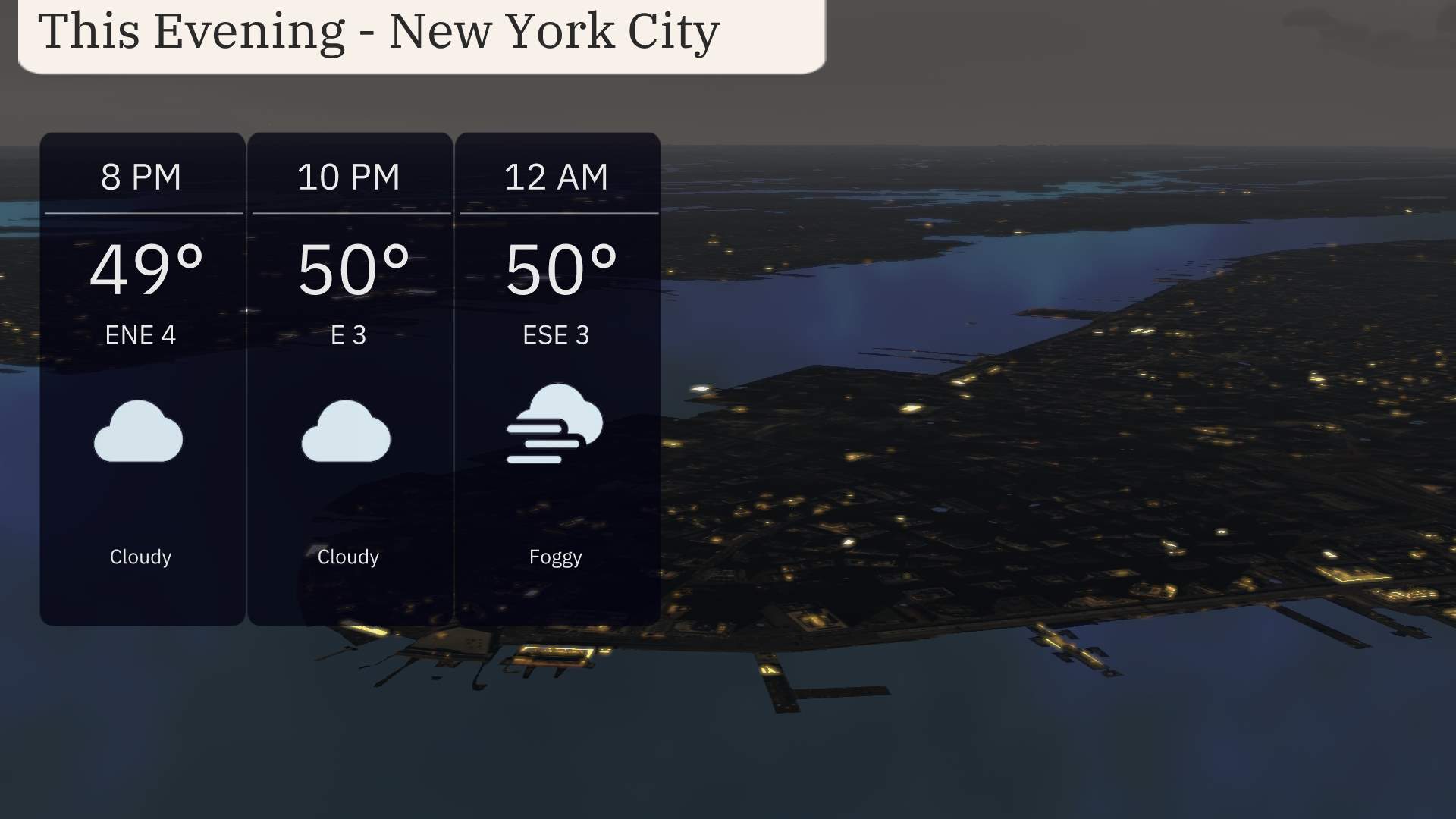
For this evening in New York City, anticipate temperatures holding steady at 49 degrees by 8 PM and slightly rising to 50 degrees through midnight. Winds will be gentle, shifting from east-northeast at 4 miles per hour to east-southeast at 3 miles per hour. Cloud cover will persist into the night, transitioning to foggy conditions by midnight.
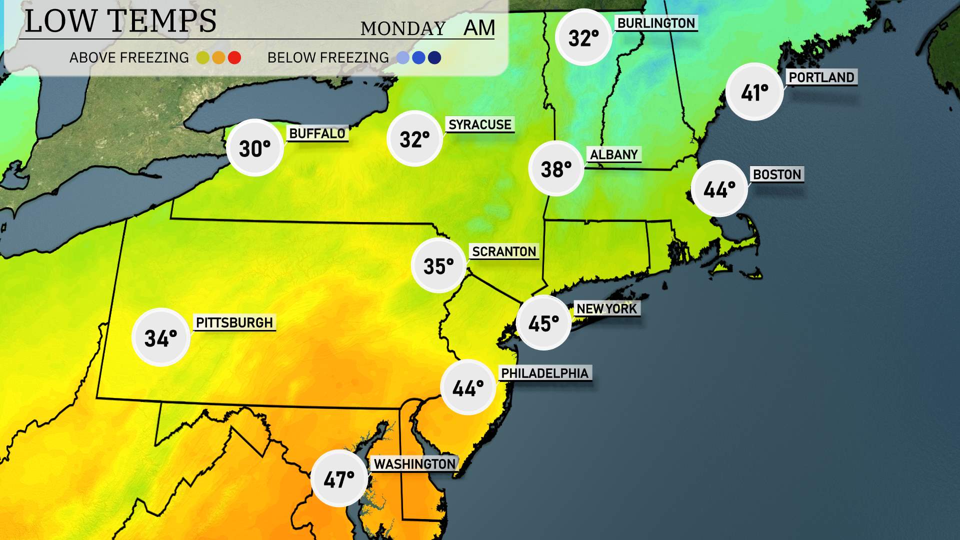
Now for the low temperatures, the Northeast is bracing for a cool night ahead. New York City will see a low of 45 degrees, while Philadelphia will be just a bit milder at 44 degrees. Buffalo will dip to 30 degrees, while Syracuse is expected to reach the freezing mark at 32 degrees. In Pennsylvania, expect a low of 34 in Pittsburgh and 35 in Scranton. Up in Albany, temperatures will fall to 38 degrees, and Boston is set for a low of 44. A cold air pattern is settling in, so be prepared for those below-average temperatures tonight.
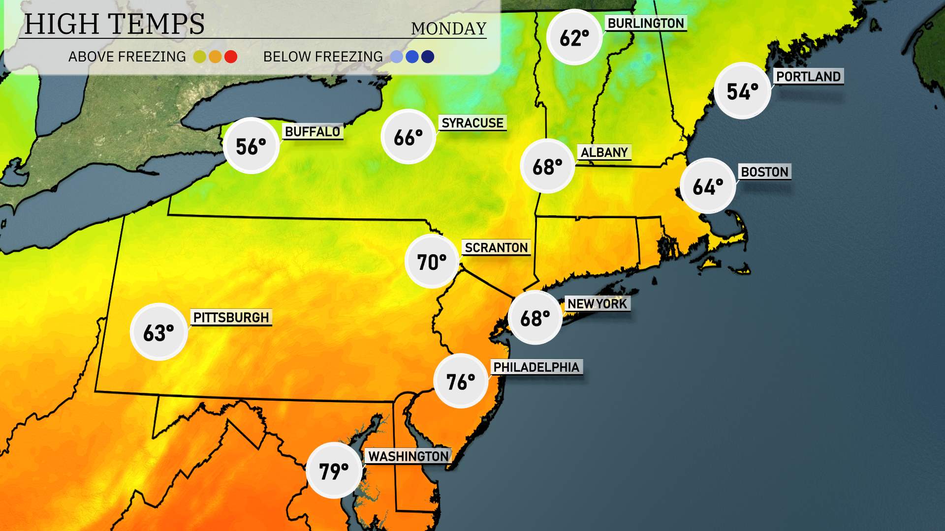
High temperatures for the Northeast region tomorrow are shaping up to be unseasonably warm, with several cities experiencing above-average readings.
Boston is expected to reach a high of 64 degrees.
New York City will climb to around 68 degrees, providing a pleasant day.
Philadelphia is warming up significantly to 76 degrees.
Scranton sees a high of 70 degrees, which is notably warm for this time of year.
Pittsburgh will see a mild 63 degrees, while Buffalo stays cooler at 56 degrees.
The warm trend is influenced by a high-pressure system moving into the area, which will result in clear skies and plenty of sunshine. This warm spell is a nice respite but is expected to be short-lived as cooler air is predicted to settle in soon.
“Tomorrow’s futurecast for the Northeast reveals a cold front passing through the region. Expect rain showers initially, with the potential for storms from New York to Albany. By afternoon, the system progresses farther east with decreasing temperatures trailing behind. Look for icy conditions around Portland and Boston as rain transitions to freezing rain in the early hours. Possibility of light snow accumulations in northern areas. Keep updated on potential severe weather alerts, especially regarding icy roads and cooler temperatures dropping into the 30s by evening.”
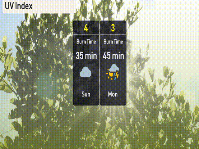
The UV index in New York City on Sunday will be moderate with a value of 4, translating to a burn time of approximately 35 minutes under direct sunlight. On Monday, expect a lower UV index of 3.
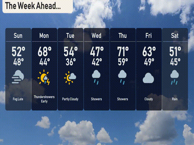
For the 7-day outlook in New York City:
Sunday: Expect fog late with a high of 52 degrees and a low of 48 degrees.
Monday: Thunder showers are likely in the early hours with a high reaching 68 degrees, dipping to 44 degrees overnight.
Tuesday: Partly cloudy skies anticipated with a high of 54 degrees and a low around 36 degrees.
Wednesday: Showers are expected with temperatures peaking at 47 degrees and dropping to 42 degrees.
Thursday: More showers are on the way with a daytime high of 71 degrees and a low of 59 degrees.
Friday: The skies turn cloudy with a high of 63 degrees, cooling down to 49 degrees at night.
Saturday: Look out for rain with temperatures reaching 51 degrees and a low of 45 degrees.
Stay safe!