From Drizzles to Breezes: Navigating NYC’s Fickle Spring Weather
By
Amy Freeze
Meteorologist Amy Freeze guides us through a week of unpredictable weather in New York City—from soothing showers to brief bouts of warmth—here's what you need to know.
Get ready for a roller-coaster of weather changes in NYC! Meteorologist Amy Freeze breaks down what to expect in the coming days, including thunderstorms, chilly nights, and pleasant daytime highs.
Join Amy Freeze as she dives into the complex weather patterns affecting New York City and the greater Northeast region this week. From unexpected evening thunderstorms to delightful daytime warm-ups, learn how these shifts impact your daily routines and how to best prepare for each day. With strategic tips on managing fluctuating temperatures and precipitation levels, our blog ensures you’re not just weather-aware but weather-prepared!
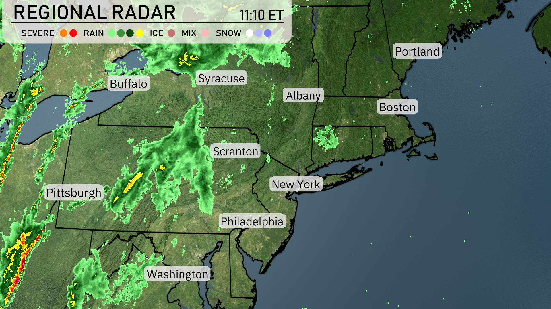
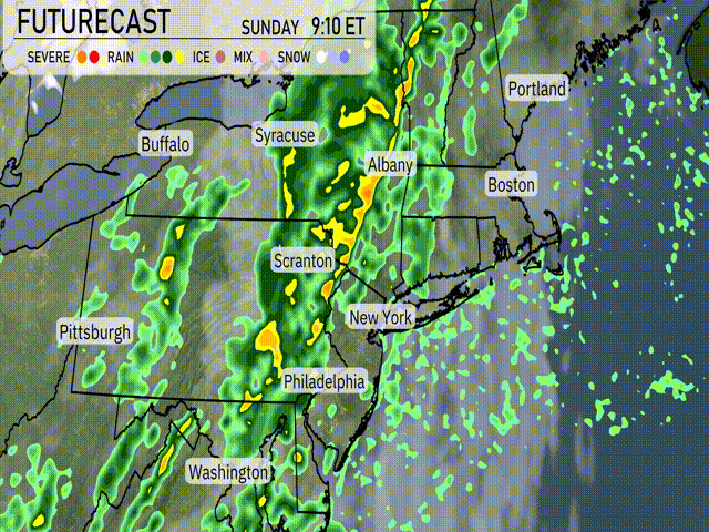
A band of rain is sweeping across the Northeast, with the heaviest precipitation focused on central and western Pennsylvania, making Pittsburgh quite wet. Syracuse is seeing some scattered rain showers as well. Further east, clouds are beginning to increase over the skies of Albany and New York City, heralding the arrival of more rain. Meanwhile, Boston and Portland are currently experiencing dry conditions, though they should prep for potential showers later on. Upstate New York near Buffalo is starting to clear out, with light showers tapering off. Coastal regions, from Washington to Philadelphia, are experiencing breaks in precipitation.
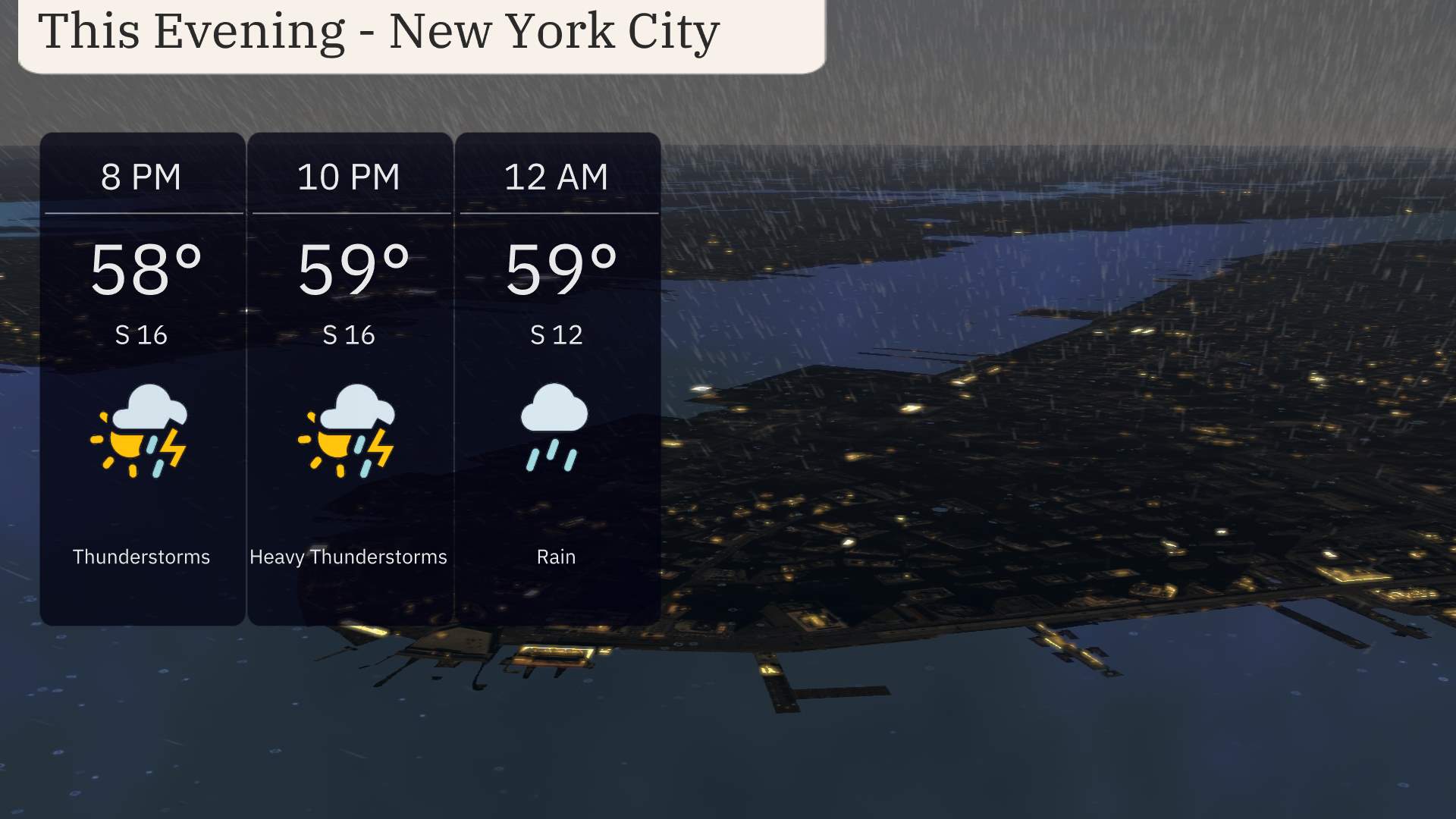
For this evening in New York City, temperatures will hold steady around 58 degrees at 8 PM, rising slightly to 59 degrees by 10 PM. Expect heavy thunderstorms moving in, with winds from the south at 16 miles per hour. By midnight, rain continues and winds ease to 12 miles per hour. Keep an umbrella handy if you’re heading out tonight.
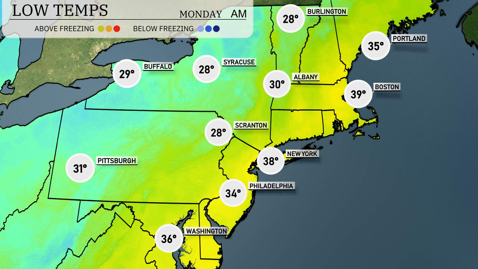
In the Northeast, expect some chilly temperatures as colder air settles in. Buffalo will drop to a brisk 29 degrees. Syracuse is forecasted to hit 28, while Scranton will also see a low of 28 degrees. Pittsburgh isn’t far behind at 31 degrees. Moving south, Philadelphia will cool down to 34 degrees. New York City will see a milder 38, and Boston will linger at 39. A significant drop will be felt in areas like Albany, where temps could reach as low as 30 degrees. Stay warm, everyone!
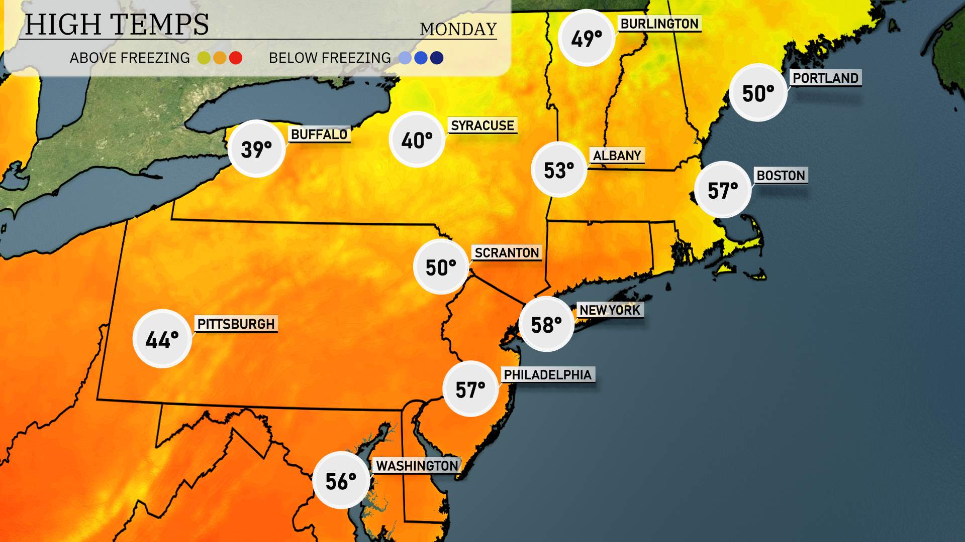
High temperatures for the Northeast tomorrow are looking quite pleasant as spring approaches. New York City is forecasted to reach a high of 58 degrees, slightly above average for this time of year. Philadelphia will enjoy similar conditions with a high of 57 degrees. Farther north, Boston is expected to see a warm high of 57 degrees as well.
Pittsburgh will be on the cooler side with highs around 44 degrees, indicating a notable difference in temperatures within the region. Scranton and Syracuse will register highs of 50 degrees and 40 degrees, respectively. In contrast, Albany is set to see a more comfortable high of 53 degrees.
Overall, a gentle warm-up is underway, influenced by a ridge of high pressure, making for a mild day across much of the Northeast.
“A cold front is set to move through the Northeast tomorrow, bringing with it a wave of rain and potential thunderstorms. Expect rainfall beginning in the morning through the afternoon, hitting areas from Philadelphia up to Boston. Some storms could be strong, with heavy downpours in places like New York City and Albany. Temperature drops will follow the front, with cooler air settling in by late evening. Be prepared for wet conditions and localized flooding, especially in low-lying areas. Use caution while traveling, and stay updated on any severe weather alerts.”
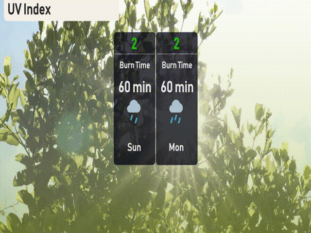
The UV index in New York City is low today and tomorrow at a level of 2. With storms and cloud cover, there’s little to no significant sun exposure expected. Keep those umbrellas handy, and enjoy the break from UV rays while staying safe from the rain.
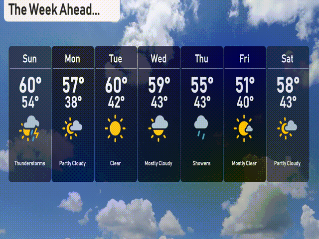
For the 7-day forecast in New York City:
Sunday: Thunderstorms are expected with a high of 60 degrees and a low of 54.
Monday: Partly cloudy conditions with temperatures around 57 degrees for the high, cooling down to 38 at night.
Tuesday: Clear skies with the temperature rising to a pleasant 60 degrees and a low of 42 degrees.
Wednesday: Mostly cloudy with a high of 59 degrees and a low of 43.
Thursday: Showers are anticipated with a high reaching 55 degrees and a low of 43 degrees.
Friday: Mostly clear skies with temperatures peaking at 51 degrees during the day and dropping to 40 at night.
Saturday: Partly cloudy with a daytime high of 58 degrees and an overnight low of 43 degrees.