NYC’s Sizzling Summer Forecast: From Heatwaves to Thunderstorms
By
Amy Freeze
Explore the dynamic summer weather patterns hitting NYC this week from sultry heatwaves to cooling thunderstorms.
This week in NYC, experience a rollercoaster of temperatures and storms. With highs reaching up to 101 degrees and thunderstorms bringing needed relief, find out how to plan your days with our latest weather insights.
Welcome to your detailed guide on what to expect from the weather in NYC this summer. The city rides a wave of high temperatures with peaks at 101 degrees, interspersed with vital thunderstorm activity offering a reprieve from the heat. We’ll be looking at daily weather changes from clear skies to potential showers, alongside tips on how to stay cool and safe during fluctuating conditions. Check the full forecast and stay prepared with the latest updates at https://amyfreeze.ai/
A dynamic weather pattern today over the Northeast as storms with intense rainfall and potentially severe conditions cover the areas around Albany and Syracuse, moving eastward. Portland and Boston are on alert with approaching showers from the west, increasing in intensity. Scranton and New York remain mostly dry as they sit just outside the current storm activity, but cloud cover is present. While Washington and Philadelphia stay calm under clearer skies, it’s important for those north to remain vigilant as this active system progresses.
New York City this afternoon brings a hot and mostly cloudy pattern with temperatures starting at 94 degrees by 4 PM. Look for a westerly wind at 8 mph to provide a slight breeze. Temperatures will ease slightly to 92 degrees by 6 PM as clouds persist. By 8 PM, expect a drop to 90 degrees with a shift to a west-northwest wind at 6 mph, continuing the mostly cloudy trend.
Scranton’s high is a warm 88 degrees, with Albany close behind at 89. Up north, Buffalo is feeling the heat as well, reaching 80 degrees. Boston isn’t far behind, set to hit 92 degrees this afternoon, making it a hot day across the region.
Tonight in the Northeast, low temperatures will be mild for the season. New York City will see a low of 79 degrees, while Philadelphia stays warm at 80 degrees. Scranton will cool down to 72, and Buffalo will dip to 72 as well.
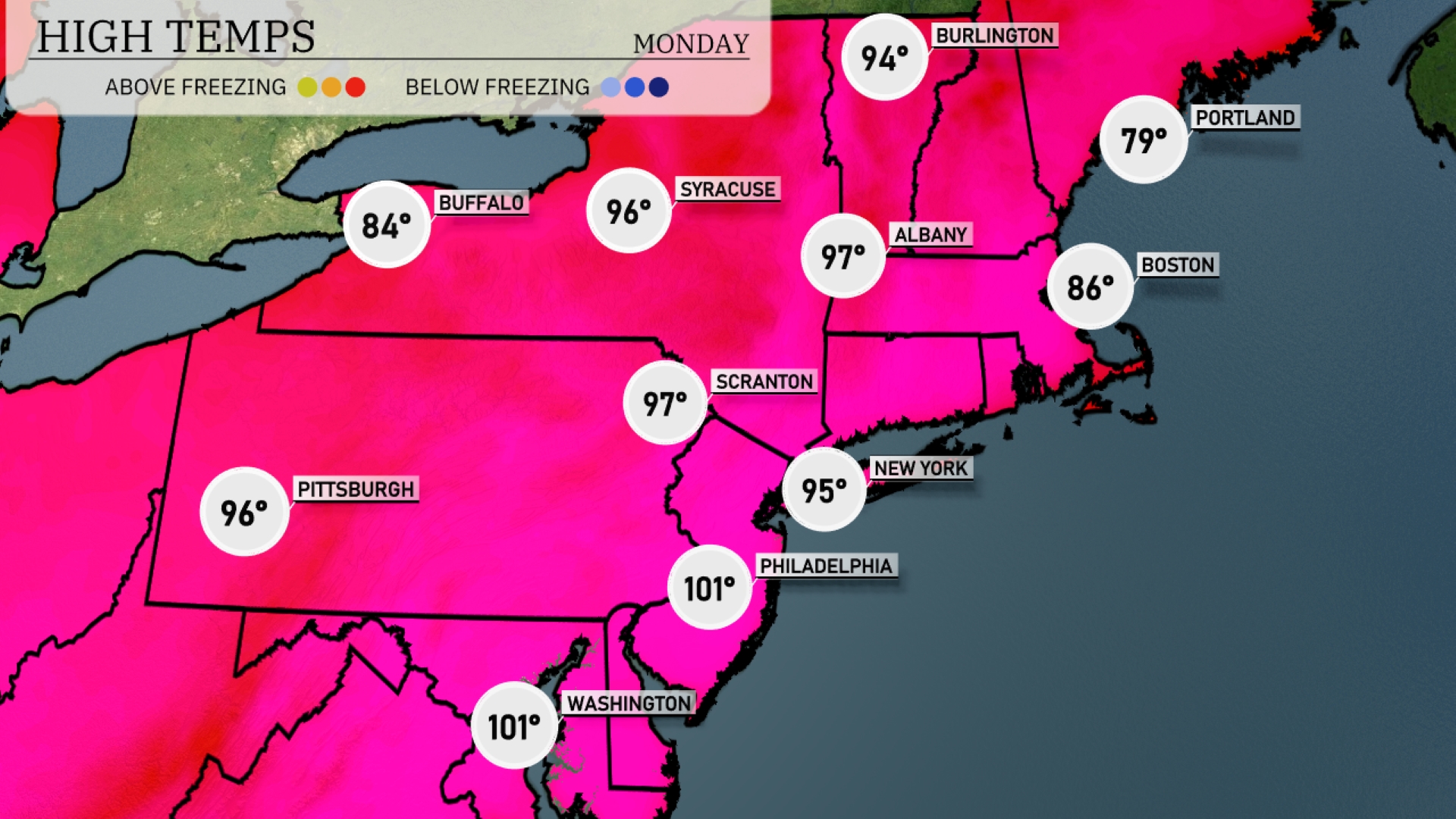
Tomorrow in the Northeast, the temperatures soar with Philadelphia hitting a scorching 101 degrees, while New York City reaches a sultry 95. Scranton follows closely at 97 degrees, with Syracuse slightly warmer at 96. Pittsburgh will see high temperatures around 96 degrees, and Albany is expected to reach 97. Portland stays cooler at 79 degrees, providing a brief respite from the heat wave sweeping the region.
A warm front is set to push through the Northeast tomorrow, bringing scattered showers and thunderstorms, especially from Albany to New York City by the afternoon. Expect periods of heavy rain, with potential localized flooding in harder-hit areas. High temperatures will hover in the mid to upper 70s across much of the region, with cooler conditions along the coast. The passage of this front will lead to drier and more stable weather by late Wednesday.
The UV index in NYC is set to be high at 7 on Sunday, with a burn time of approximately 20 minutes in direct sunlight. As Monday approaches, expect an increase in the index to 9, bringing a quicker burn time of about 15 minutes.