NYC Weather Alert: Storm Updates and Weekly Forecast
By
Amy Freeze
Discover comprehensive updates on the ongoing storms sweeping across the Northeast and a detailed forecast for the upcoming week in NYC.
An update on the NYC weather: Current storms in the Northeast and a look ahead at what to expect this week. From scattered showers to sunny days, stay prepared with our detailed guide.
Current storms are sweeping across the Northeast, impacting areas from Pittsburgh to Portland. In NYC, expect temperatures ranging from mid-70s in the day to low 60s at night this week. Check details on rain, temperatures, and UV index forecasts for effective daily planning.
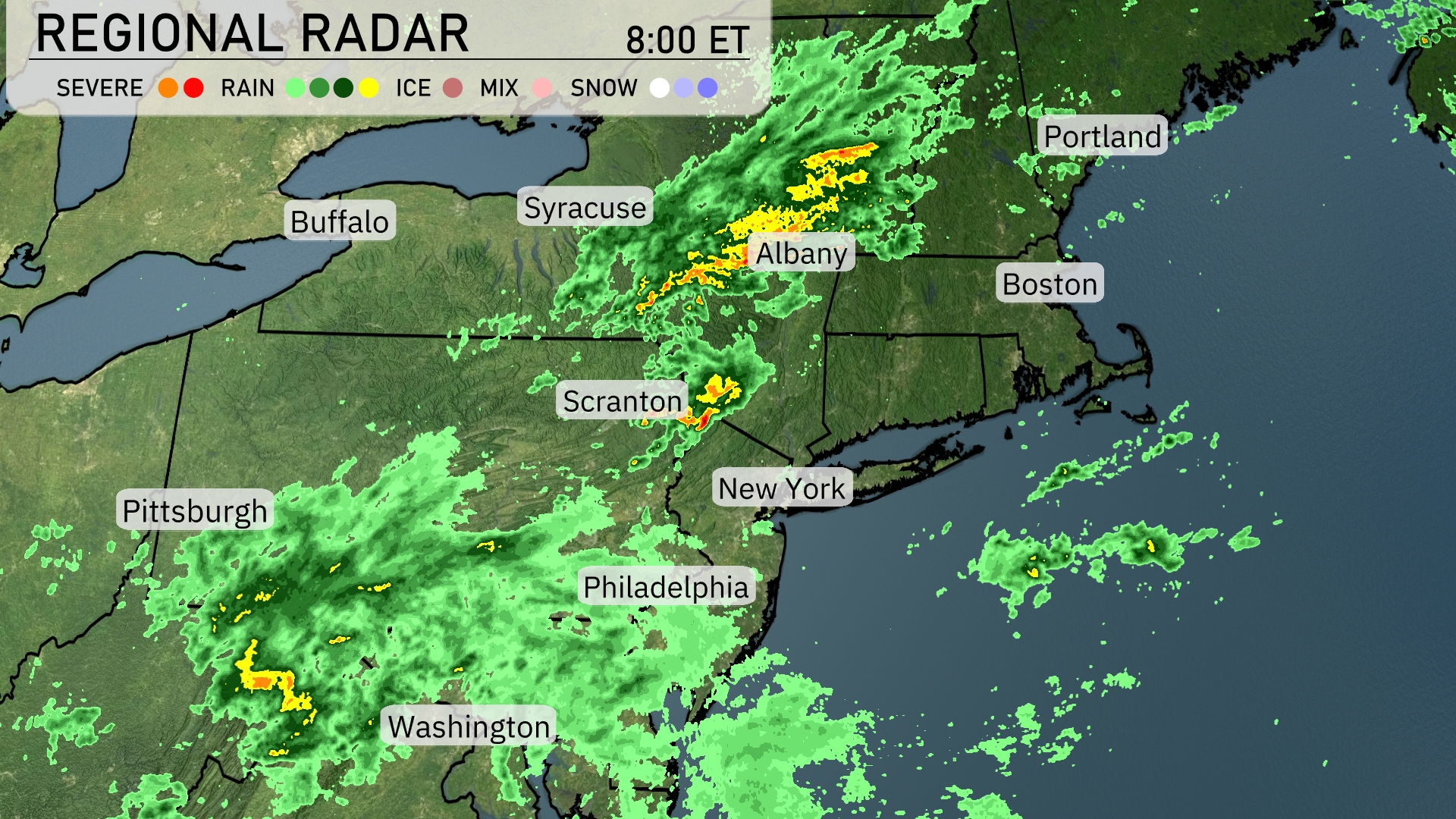
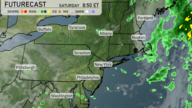
A line of storms is sweeping across the Northeast, with severe weather moving through Albany and heading towards Boston. Rain is blanketing the region from Pittsburgh to Philadelphia and extending into New York City, where showers are currently heavy. Scranton is experiencing active rain with some embedded thunderstorms, while Syracuse sees lighter precipitation. Portland remains mostly dry, though cloud cover is beginning to increase in the area.
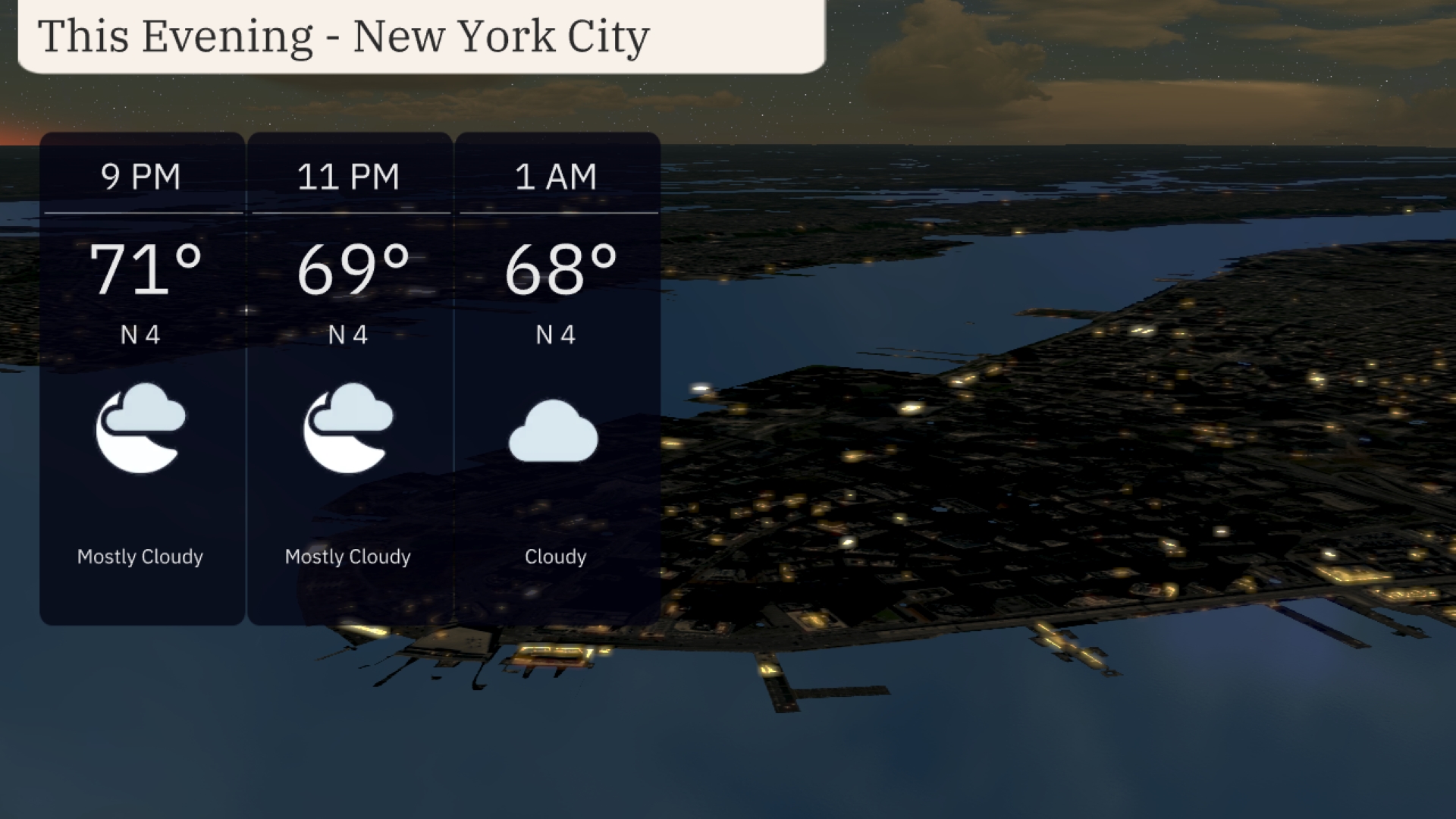
For this evening in New York City, plan for a mostly cloudy sky with temperatures starting at 71 degrees at 9 PM, gradually descending to 68 degrees by 1 AM. The northeast wind will blow gently at 4 mph throughout the evening.
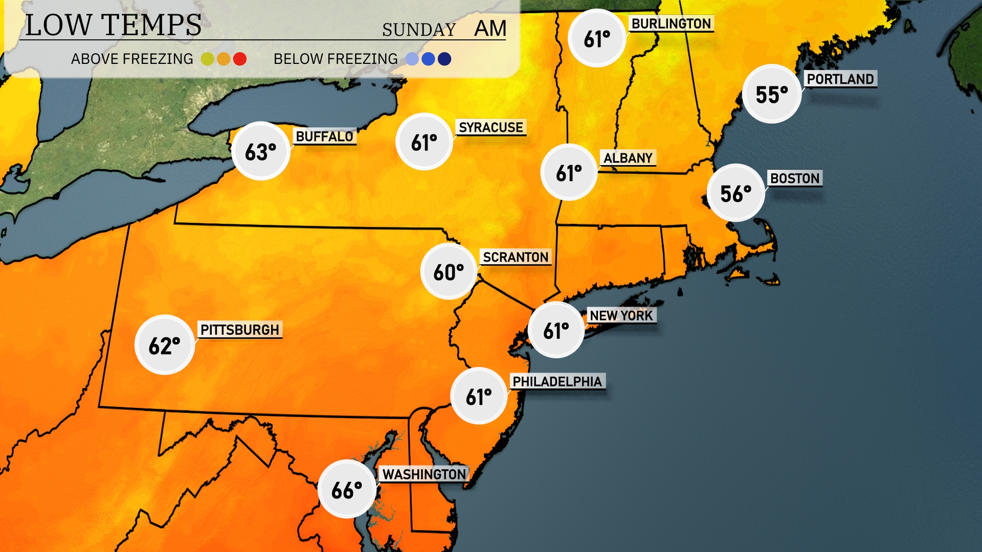
Tonight, temperatures will dip to 55 degrees in Portland. Boston is expected to cool down to 56 degrees, while New York will see a low of 61. In Scranton, temperatures will drop to 60 degrees, with Pittsburgh slightly cooler at 62.
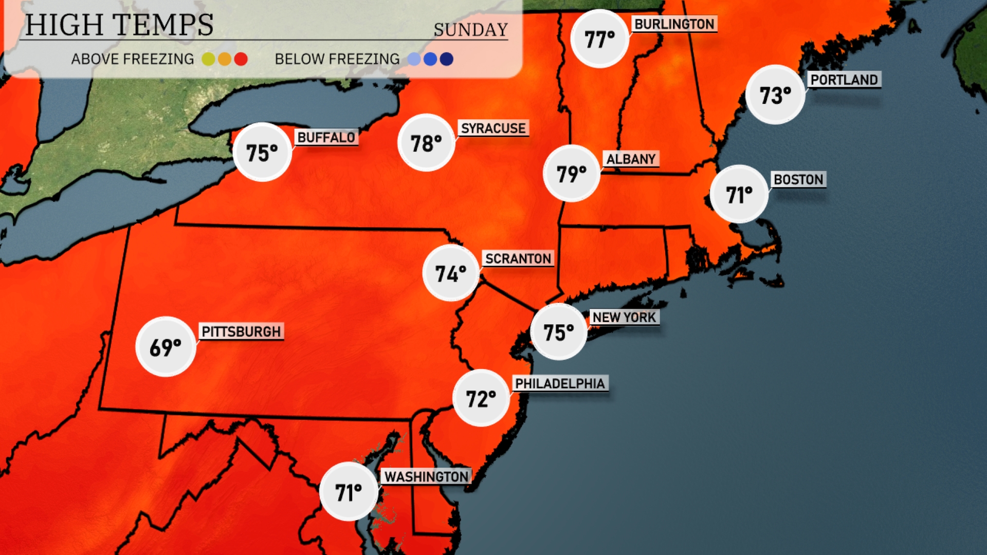
Tomorrow in the Northeast region, temperatures will be notably warm for early June. New York City is expected to reach a high of 75 degrees, while Philadelphia will see slightly cooler temperatures at 72 degrees. Albany will top out at 79 degrees, making it one of the warmest spots in the area. Scranton will be pleasantly warm at 74 degrees, whereas Pittsburgh will linger around 69 degrees.
A warm front will bring scattered showers to the Northeast tomorrow, with heavier rain expected in the morning around Boston and into the afternoon over Albany. Syracuse might see isolated thunderstorms during the afternoon hours. Conditions are drying out by evening, with Skies clearing overnight from New York to Philadelphia. Temperatures will range from mid-70s in the afternoon, cooling down into the low 60s by nightfall. Be prepared for potential localized flooding in areas of heavier rain.
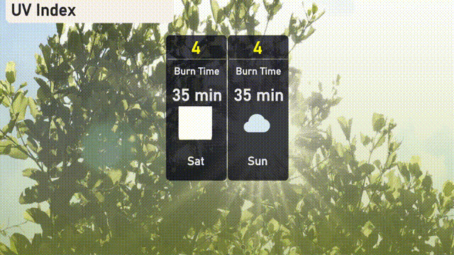
The UV index in New York City will be moderate at 4 on Saturday and Sunday, indicating a burn time of about 35 minutes in direct sunlight.
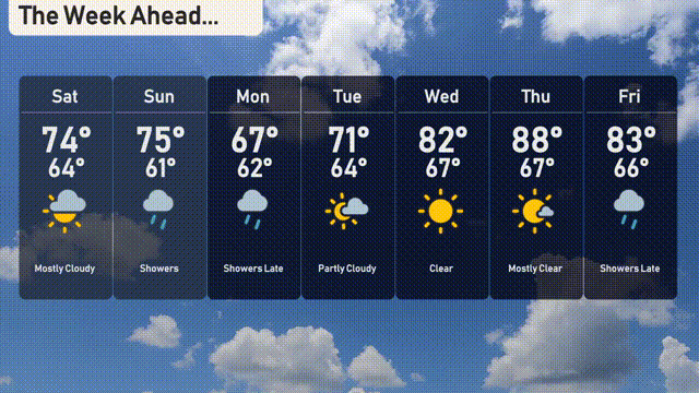
Saturday: Mostly cloudy with a high of 74 degrees and a low of 64 degrees.
Sunday: Expect showers with temperatures reaching 75 degrees during the day and cooling to 61 degrees at night.
Monday: More showers in the late hours with a high of 67 degrees and a low of 62 degrees.
Tuesday: Partly cloudy skies prevailing, temperatures peaking at 71 degrees and dipping to 64 degrees overnight.
Wednesday: Clear and sunny, enjoy a high of 82 degrees and a low of 67 degrees.
Thursday: Mostly clear conditions with a warm high of 88 degrees and a low of 67 degrees.
Friday: Showers expected late, with temperatures reaching 83 degrees during the day and falling to 66 degrees.