NYC Weather Snapshot: Evening Showers & A Glimpse into Next Week
By
Amy Freeze
Navigate through New York City's mix of evening showers and clear spells, while gearing up for the weather trends of the coming week.
This week in New York City, brace for varied weather from evening showers to sunny days. Find out the highs, lows, and rain potentials—stay prepared!
An insightful dive into NYC’s weather for June 14, 2025, as we explore the dynamics of evening showers and the start of a wet week ahead. Learn about temperature trends from low 50s to high 80s, the chances of rain, and how these conditions could affect your daily plans. Plus, detailed forecasts for key cities in the Northeast. Whether you’re in NYC or nearby, know what to expect from the skies!
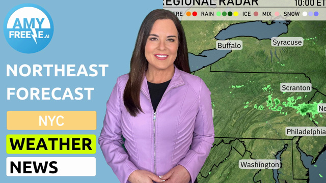
The Northeast is experiencing widespread precipitation with areas of rain extending from Pittsburgh across to New York City and north to Portland. Heavy rainfall is concentrated around Scranton and near Pittsburgh, where thunderstorms are possible. Some rain showers are lingering from Syracuse to Albany. Those in Philadelphia and Washington may see overcast conditions, with rain beginning to move in from the west.
This evening in New York City, temperatures will remain steady at 62 degrees from 9 PM through 1 AM. Wind will be gentle from the northeast at 10 miles per hour, tapering slightly through the night. Expect a few showers around 9 PM, transitioning to cloudy skies as the night progresses. Dress accordingly if you’re out and about under the cloudy cover.
Tonight, Boston will dip to 54 degrees, while Portland sees a cooler low of 53. In New York, expect a mild 61 degrees, with Philadelphia just a bit cooler at 60 degrees. Scranton will experience a drop to 59 degrees, and Syracuse follows closely at 58 degrees. Buffalo remains warmer at 60 degrees.
Tomorrow in Buffalo, temperatures will soar to a high of 78 degrees, while Pittsburgh warms up to 76. Syracuse is set to reach 74 degrees, and Albany is not far behind at 72. In contrast, coastal cities like Boston and Portland will experience cooler highs of 66 and 65 degrees, respectively.
A low-pressure system will impact the Northeast starting tomorrow, bringing showers from Washington, D.C. to New York City in the morning, extending into Albany and Syracuse by the afternoon. Expect periods of heavy rain, particularly around Philadelphia and Scranton, which could lead to localized flooding. Temperatures will range from the mid-60s to low-70s, remaining mild despite the rain. In the evening, showers may taper off, but lingering clouds will keep the region overcast. There are no severe weather risks anticipated, but stay prepared for wet conditions on the roads.
The UV index in New York City will be low on Saturday at 3, with cloudy conditions and storms potentially reducing exposure. On Sunday, it rises to a moderate level of 4, which means a burn time of about 35 minutes in direct sunlight.
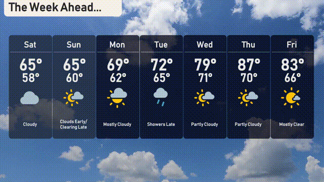
Saturday: Cloudy with a high of 65 degrees and a low of 58.
Sunday: Morning clouds giving way to sunshine, expect a high of 65 degrees and a low of 60.
Monday: Mostly cloudy throughout the day, with temperatures reaching 69 degrees and dipping to 62 overnight.
Tuesday: Shower chances rise, with a daytime high of 72 degrees and a low of 65 degrees.
Wednesday: Partly cloudy skies, warming up to 79 degrees, with a nighttime low of 71.
Thursday: Partly cloudy and warmer with highs reaching 87 degrees and a low of 70.
Friday: Mostly clear skies wrapping up the week, high temperatures around 83 degrees and a low of 66.