The Big Apple’s Big Weather Shift: From Showers to Sunshine
By
Amy Freeze
Dive into our latest blog post where Amy Freeze enlightens us on the contrasting weather patterns over NYC and the Northeast. From icy rain to sunny days, learn what’s in store for the week.
Expect changes in NYC’s weather from rain to sunshine! Meteorologist Amy Freeze guides you through the latest forecasts.
Meteorologist Amy Freeze here with your detailed weather outlook for New York City and the entire Northeast. Tomorrow promises a variety of weather conditions, from partly cloudy skies to rain and even snow in certain regions. Temperatures will range widely across the area, so be prepared for a chilly morning but a warmer afternoon. Don’t miss out on any updates and stay equipped for a dynamic weather day! For more detailed forecasts and tips, check out our full blog post at [https://amyfreeze.ai/](https://amyfreeze.ai/).
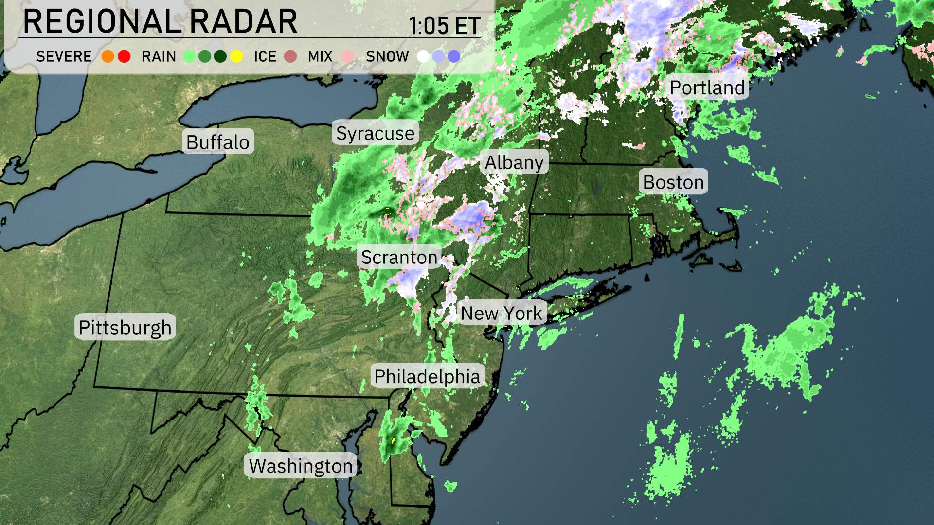
In the Northeast, the regional radar is buzzing with activity. A significant band of rain is stretching from Washington, D.C., northward to Syracuse. Along this stretch, cities like Philadelphia and Scranton are experiencing steady precipitation. Meanwhile, Albany sees a mix of rain and snow, adding a wintery touch to the forecast.
Snow showers are predominantly affecting areas farther north and east, from Syracuse eastward to Buffalo, transitioning into heavier snow bands as you move into the higher elevations of the region. Boston and Portland are on the cusp of these snow showers, with Portland seeing more consistent snowfall.
In contrast, New York is situated under lighter rain, with showers lining the coast and progressively clearing as you move inland. Farther south, clouds are increasing over Washington, D.C., setting the stage for a wetter afternoon.
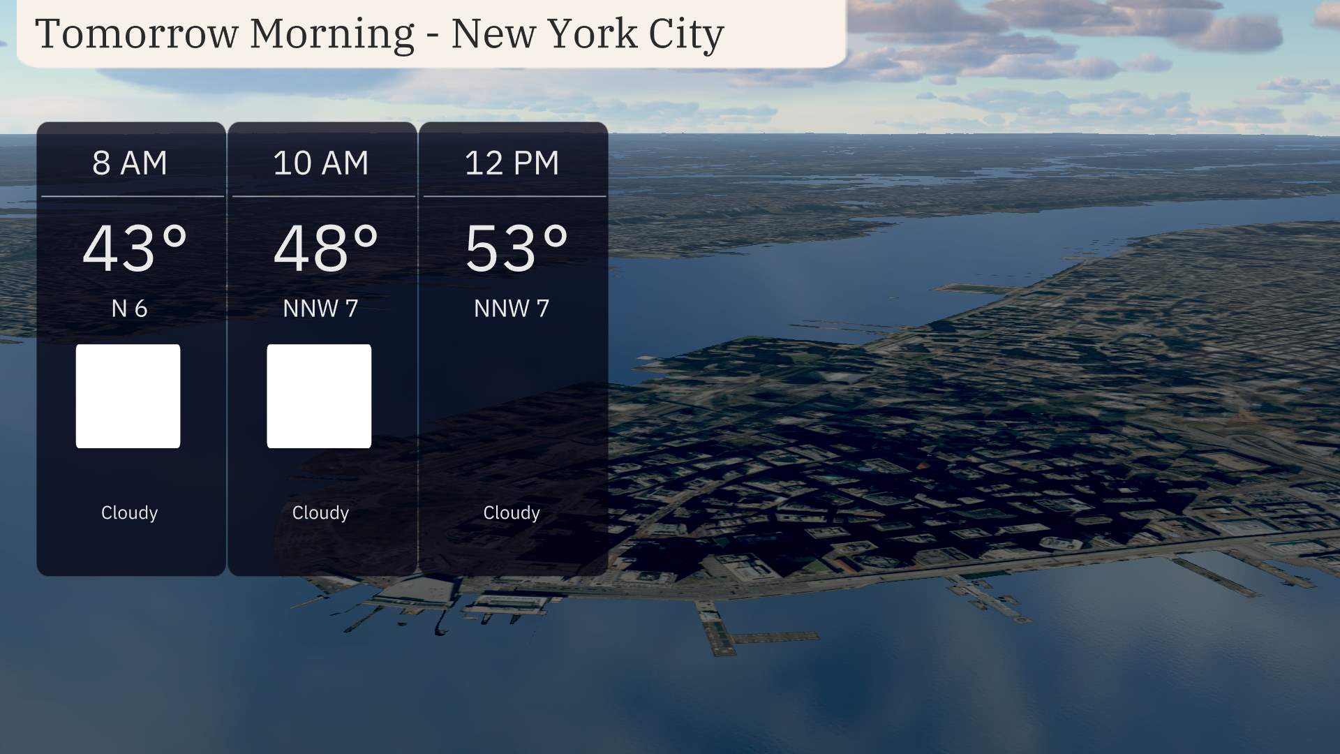
Expect a cloudy start to your morning in New York City. Temperatures begin at 43 degrees around 8 AM. By 10 AM, temperatures will rise to 48 degrees with a north-northwest wind at 7 mph. The day progresses smoothly, reaching 53 degrees by noon as the wind holds steady. Plan for a day with no significant weather disruptions. Enjoy a calm start to your day in the Big Apple!
For tomorrow, expect a warm day across the Northeast as temperatures rise significantly.
In New York City, the high will reach 59 degrees, while Philadelphia is set to warm up to 61 degrees, slightly above the seasonal average. Pittsburgh could see a high of 61 as well, matching Philly.
Moving towards the northern parts, Syracuse and Scranton will have similar highs around 55 degrees, just slightly above typical readings for this time of year. Buffalo will be a bit cooler at 52 degrees.
Out east, Boston will remain on the chilly side with a high of 46 degrees, while Portland, Maine, is expected to only hit 43 degrees, well below the trend in the region.
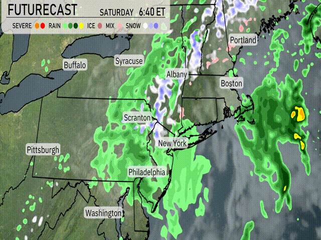
Across the Northeast, a dynamic weather system is setting the stage for Saturday. Expect widespread rain showers from Scranton to Boston, with heavier downpours likely around New York City and into Albany. Temperatures will be cool throughout the region, with some snow mixing in across higher elevations.
As this system pushes through, be prepared for potential travel disruptions due to rain-slicked roads and reduced visibility. Syracuse may see some icing early morning before temperatures rise. Further north, Portland could experience a quick shot of snow before transitioning to rain by afternoon.
Keep an eye out for any advisories from the N-W-S, as conditions may vary rapidly. As the front exits, temperatures stabilize into Sunday, bringing drier weather for most. However, expect a lingering shower or two along coastal areas. Stay prepared for any sudden weather changes!
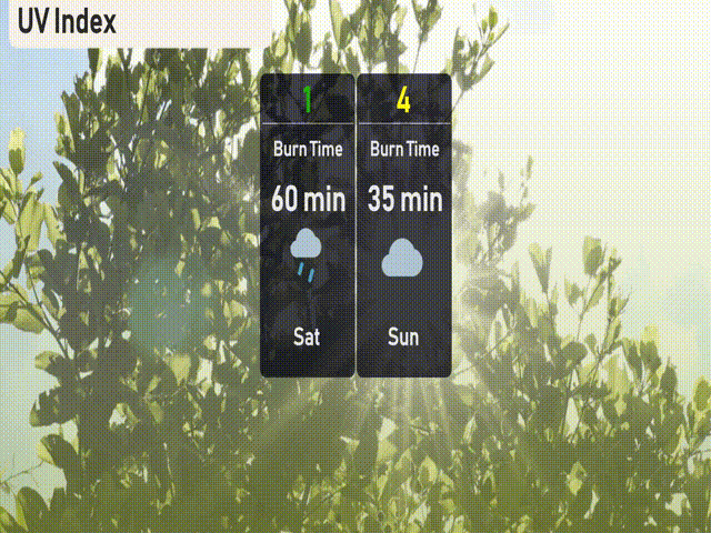
The UV index in New York City today is low at 1, due to heavy cloud cover and rain, keeping UV exposure minimal. For tomorrow, Sunday, the UV index increases to 4, indicating moderate sun exposure with a burn time of about 35 minutes.
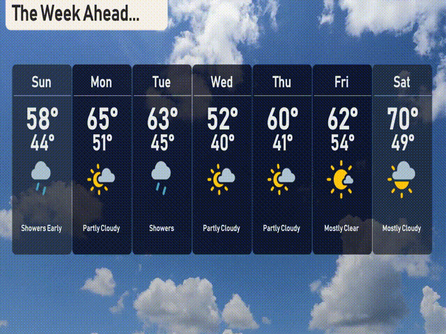
For the 7-day forecast in New York City:
Sunday: Showers early with a high of 58 degrees and a low of 44 degrees.
Monday: Partly cloudy conditions, temperatures rising to 65 degrees during the day, cooling to 51 degrees at night.
Tuesday: Expect showers with a day high of 63 degrees, dropping to 45 degrees overnight.
Wednesday: Partly cloudy skies, cooler with temperatures reaching 52 degrees and dropping to 40 degrees.
Thursday: Partly cloudy and slightly warmer, with a high of 60 degrees and a low of 41 degrees.
Friday: The sky clears to mostly clear conditions, with temperatures peaking at 62 degrees and a low of 54 degrees.
Saturday: Mostly cloudy, with a warming trend bringing a high of 70 degrees and a night low of 49 degrees.
Hope that helps! Stay safe and enjoy your week!