NYC Weather Forecast: Sunny Evenings Ahead with a Heat Wave on the Horizon!
By
Amy Freeze
This evening, NYC enjoys partly cloudy skies with comfortable walking weather. However, a heatwave is about to hit the Northeast with temperatures expected to push into the 90s.
Tonight in NYC: Partly cloudy with a comfy 78°F. Upcoming: Brace for a heatwave with tomorrow’s highs in the 90s!
Good evening, New York! The city is set to enjoy a calm night with partly cloudy skies and temperatures starting at 80 degrees at 9 PM. By 1 AM, it slightly dips to 78 degrees. Tomorrow, prepare as temperatures rise, highlighting a scorching heat wave. New York City and Albany are expected to hit blistering highs of 88 and 90 degrees. Don’t forget your sun protection as the UV index reaches a high of 9, causing burn times of just 15 minutes. Read on for more details on how to stay cool and safe. Visit [https://amyfreeze.ai/](https://amyfreeze.ai/) for more in-depth updates and tips.
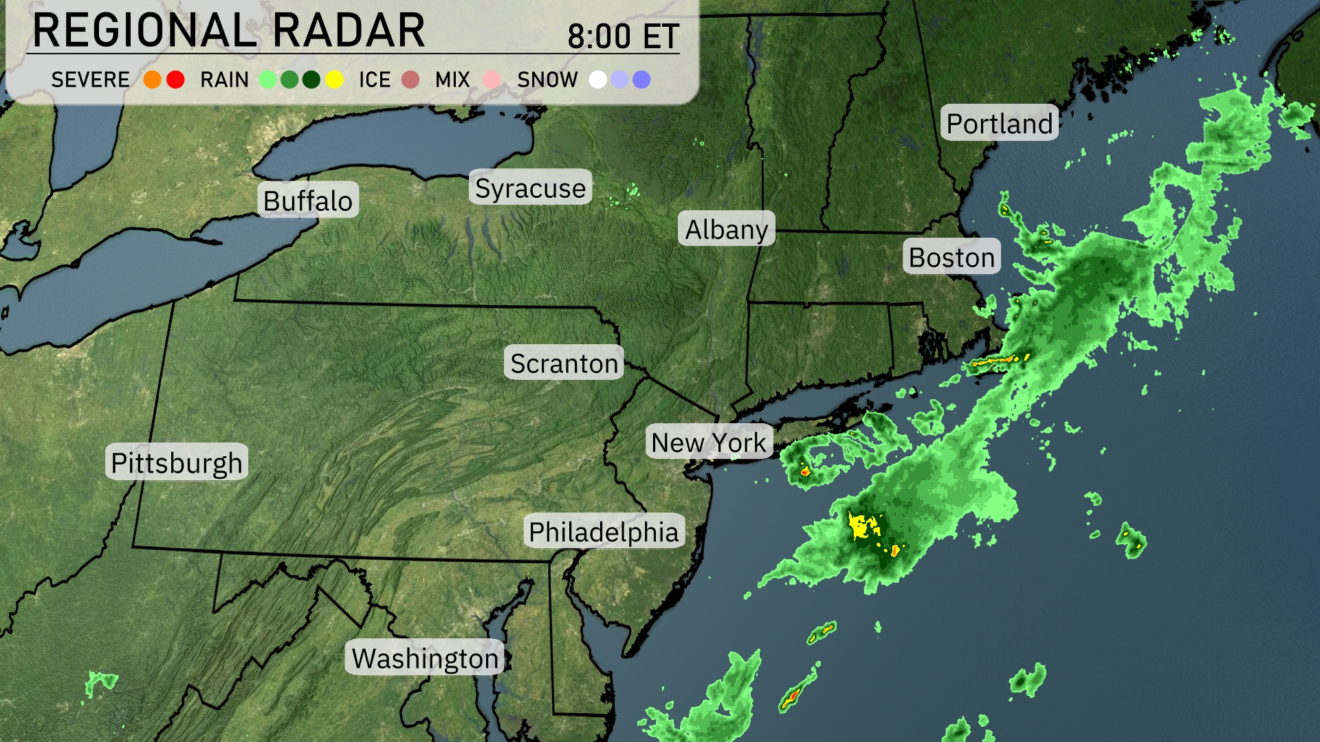
A quiet morning for the Northeast as most areas enjoy clear skies, but we do have some action off the New England coast. A band of rain is located just off the shore of Boston, stretching southeast into the Atlantic. Light rain is skimming parts of the Long Island coastline, but it’s not expected to reach into New York City. Skies remain clear from Buffalo to Washington, providing a pleasant start to the day for most of the region.
Temperatures in New York City this evening will start at 80 degrees at 9 PM, dipping slightly to 78 degrees by 1 AM. Winds will be light and variable, shifting from south at 4 miles per hour to southwest at 3 miles per hour. The sky transitions from mostly clear to partly cloudy as the night progresses. Ideal for an evening stroll or a late-night outing with calm weather conditions.
Tonight, Boston will cool down to 75 degrees, while New York City is expected to see a low of 76. Philadelphia will also drop to 76 degrees, with Scranton experiencing a slight dip to 72. Buffalo and Syracuse both match with lows of 73, maintaining relatively mild temperatures across the Northeast.
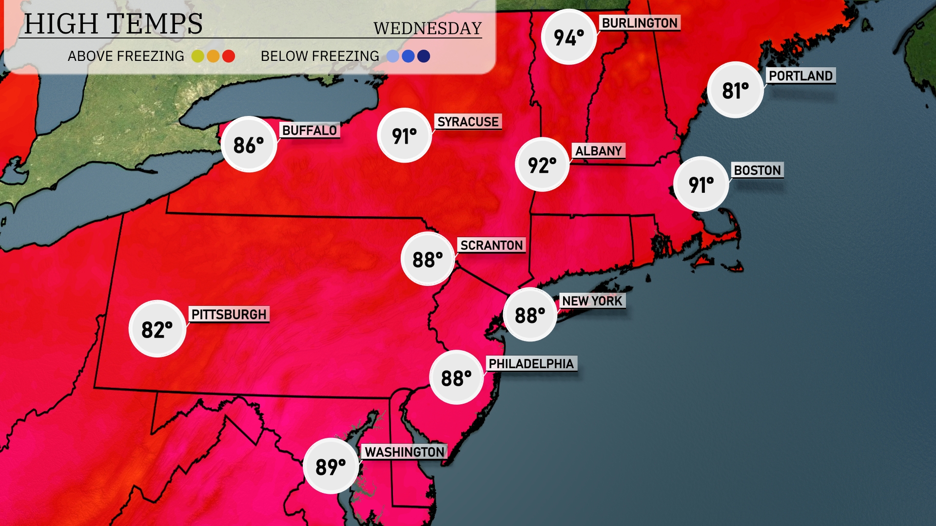
Tomorrow in the Northeast, expect high temperatures pushing into the 90s across several key cities. New York and Boston will reach 88 and 91 degrees, respectively, while Syracuse will see a scorching high of 91 degrees. Further north, Buffalo will hit 86 degrees, indicating above-average temperatures for this time of year. Philadelphia and Scranton will also warm up to 88 degrees, with humid conditions likely influencing these highs.
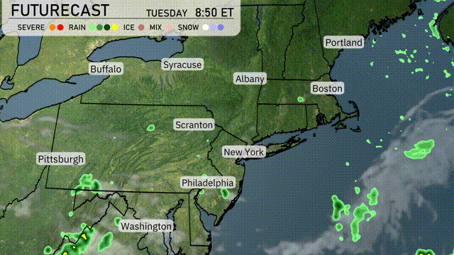
A warm front lifts into the Northeast tomorrow, bringing scattered showers and thunderstorms from Pittsburgh to Portland. The most intense storms are expected to develop in Philadelphia and New York City by mid-afternoon, potentially leading to localized flooding. Albany to Boston will experience gusty winds with passing storms. Temperatures remain seasonably warm, peaking in the mid-80s.
The UV index in New York City will be very high today with a value of 9, indicating a burn time of just 15 minutes in direct sunlight. As we move to Wednesday, expect a high UV index of 7, with a burn time of 20 minutes.
For the 7-day outlook in New York City:
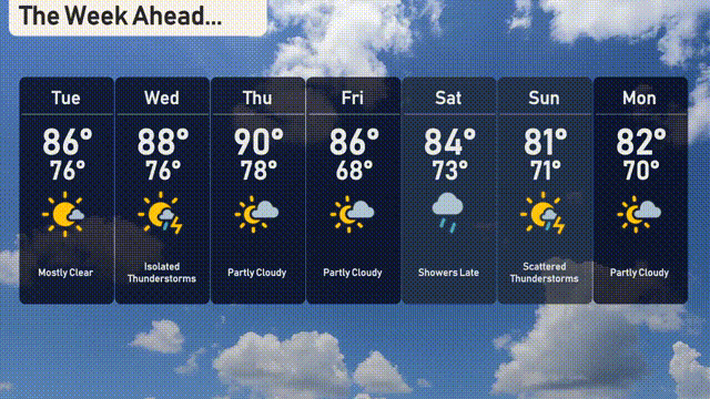
Tuesday: Mostly clear with a high of 86 degrees and a low of 76 degrees.
Wednesday: Watch for isolated thunderstorms with temperatures reaching 88 degrees during the day and 76 degrees at night.
Thursday: Partly cloudy skies with a high of 90 degrees and a comfortable nighttime low of 78 degrees.
Friday: Continued partly cloudy conditions as temperatures peak at 86 degrees, cooling down to 68 degrees overnight.
Saturday: Showers expected later in the day with highs of 84 degrees and lows around 73 degrees.
Sunday: Scattered thunderstorms keep things interesting with a high of 81 degrees and a low near 71 degrees.
Monday: Partly cloudy conditions return with temperatures reaching 82 degrees and a low of 70 degrees.