NYC Weather Forecast: Sun, Showers, and the Summer Sizzle
By
Amy Freeze
From sunny skies to thunderstorm advisories, get the full scoop on NYC's weather landscape with our detailed forecast for the coming week.
Explore the latest weather trends in NYC! Expect a mix of sunshine, thunderstorms, and delightful breezes as we delve into a detailed day-by-day analysis of what’s ahead. Stay weather-smart with our insights!
Welcome to our detailed forecast for New York City’s ever-changing weather landscape. This week prepares for a whimsical mix of partly cloudy skies, gentle summer breezes, and the occasional thunderstorm rolling from the coast. We cover temperatures peaking at balmy highs and what these shifts mean for your daily plans. From safety tips during severe weather to enjoying those unexpected sunny afternoons, our guide has everything you need to navigate the summer weather confidently.
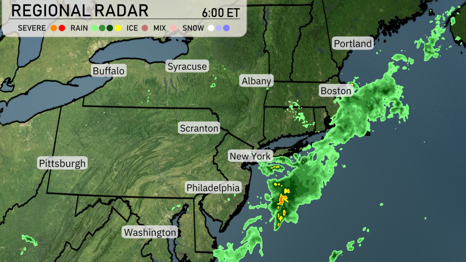
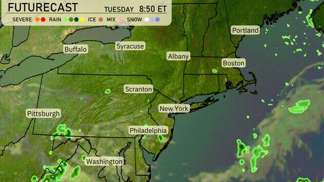
A line of thunderstorms is making its way offshore, affecting coastal areas from New Jersey up towards southern New England. The radar shows rain extending over New York City and pushing towards Boston. The clearing begins today. Syracuse and Albany are experiencing mostly clear conditions, with only a few isolated showers. Buffalo and Pittsburgh are currently enjoying dry weather.
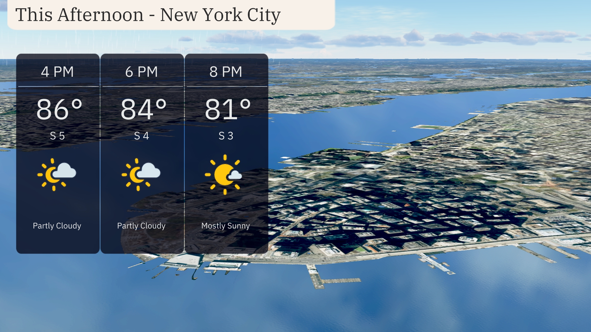
Expect a warm afternoon in New York City with temperatures reaching up to 86 degrees by 4 PM. Winds will be coming from the south at around 5 miles per hour, providing a gentle breeze. Skies will be partly cloudy, transitioning to mostly sunny conditions by 8 PM as temperatures ease to 81 degrees. Enjoy the sunshine while it lasts!
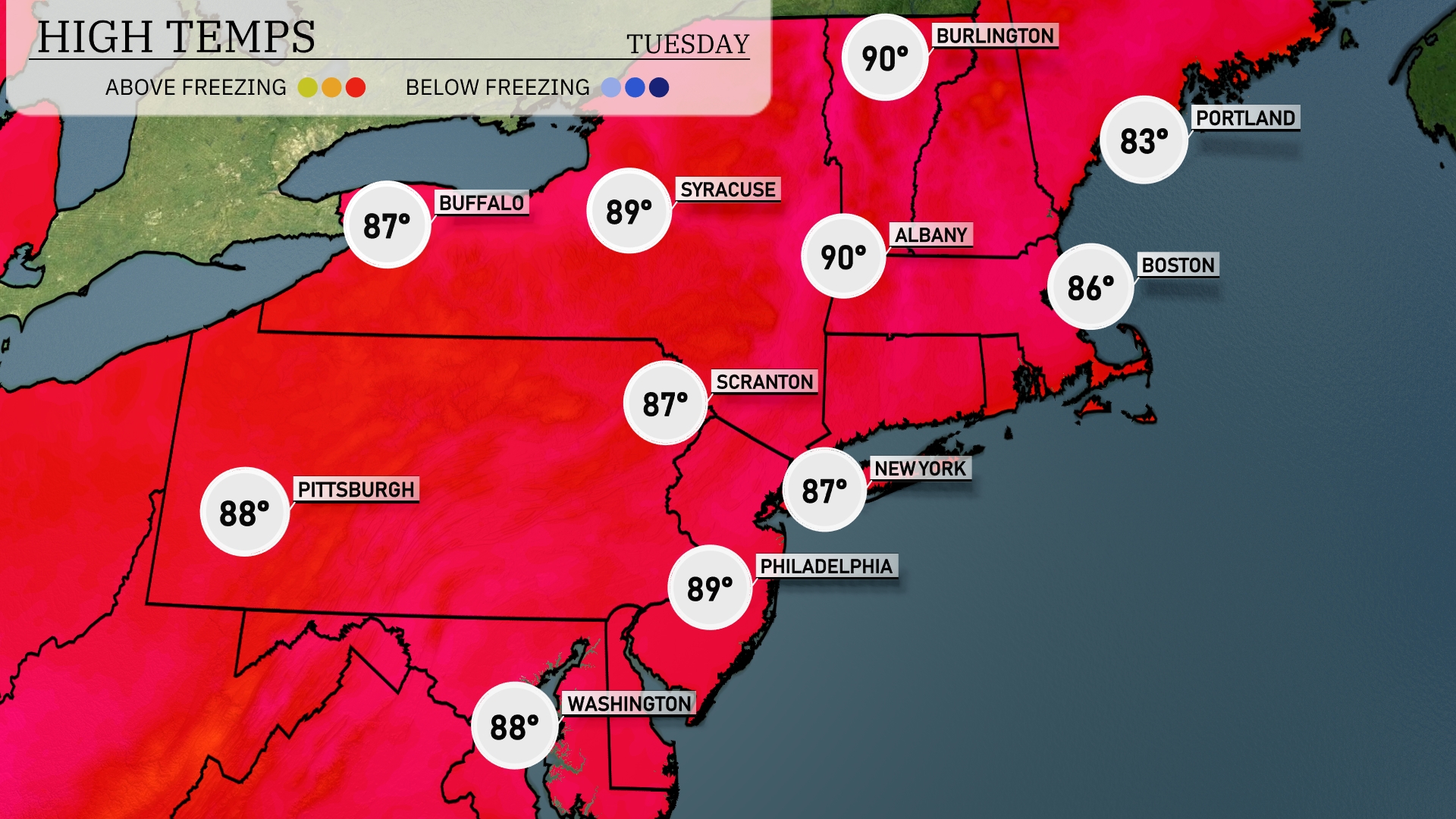
Today’s regional high temperatures are shaping up nicely across the Northeast. New York City and Albany are both hitting 90 degrees, while Philadelphia is slightly cooler at 89. Scranton and Buffalo are looking at highs of 87 degrees. Boston will stay a bit milder with a high of 86, and Portland, Maine will reach 83 degrees.
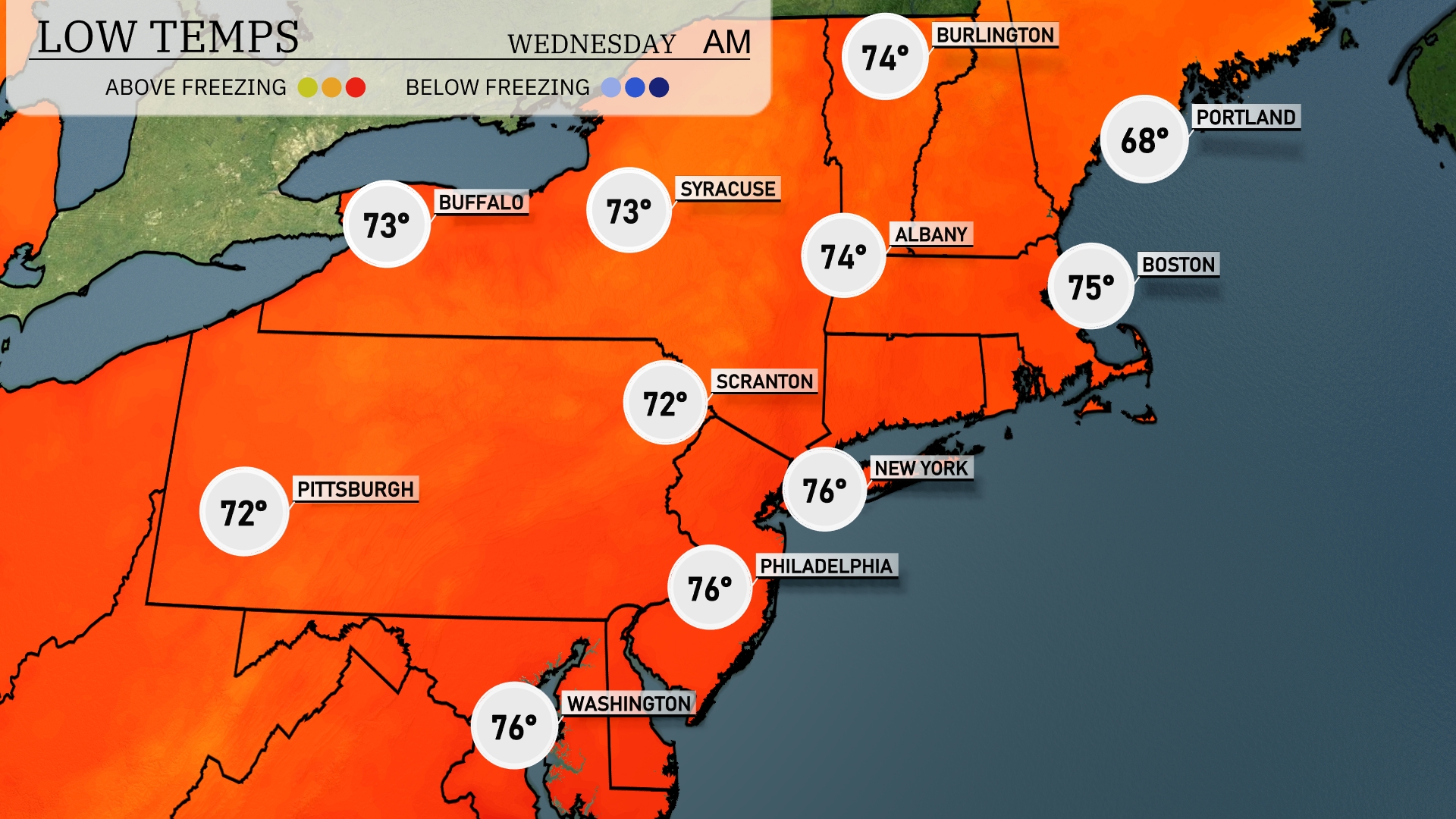
Tonight, low temperatures across the Northeast will be relatively mild, with New York City at 76 degrees and Philadelphia also staying warm at 76. Scranton will see a cool down to 72 degrees, while Buffalo and Syracuse are at 73. Boston is expected to drop to 75 degrees, with Portland cooling to 68, reflecting a slight dip as we close out the evening.
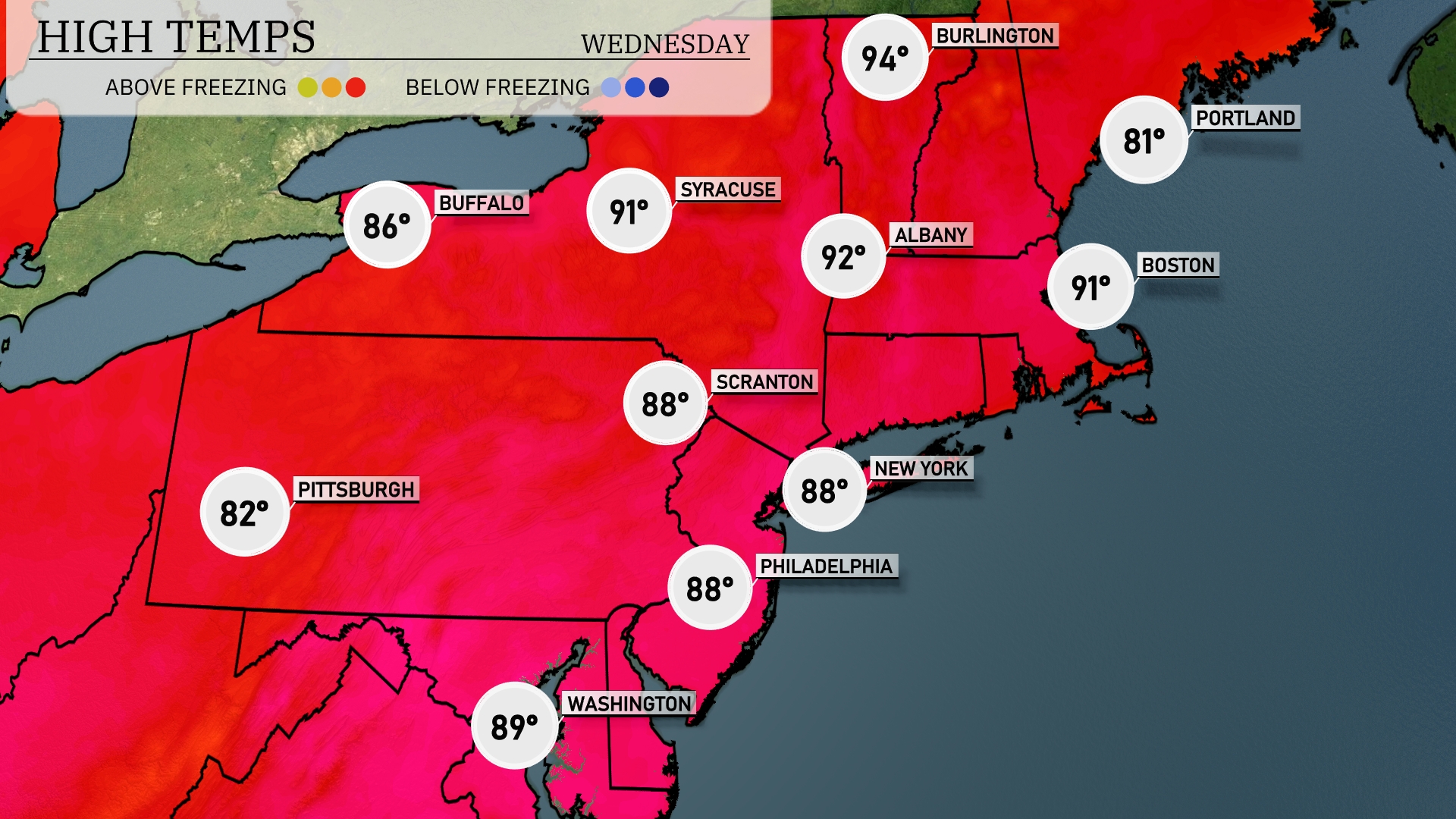
Tomorrow, the Northeast will see warm temperatures across the region, with New York and Boston both reaching 91 degrees. Philadelphia and Scranton will also expect highs of 88 degrees, indicating a trend of above-average temperatures. Buffalo will feel quite pleasant with a high of 86 degrees, while Syracuse comes in slightly warmer at 91 degrees. In Pittsburgh, temperatures will be a bit cooler at 82 degrees, but still above typical mid-July levels. Meanwhile, Washington D.C. will experience an afternoon high of 89 degrees, contributing to the region’s summery feel.
A cold front will approach the Northeast overnight, leading to showers and thunderstorms from Pittsburgh to New York City by afternoon. Expect heavy downpours and gusty winds, with Philadelphia and Washington D.C. likely to see the most intense activity in the evening. Temperatures will dip slightly post-front, dropping back to seasonal levels into Wednesday. Watch for potential localized flooding with rainfall exceeding an inch across some regions. Clear skies return by Thursday, bringing comfortable conditions with cooler air.
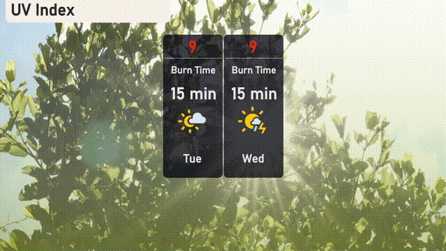
Expect a very high UV index of 9 in New York City for both Tuesday and Wednesday, with a burn time of just 15 minutes.