The Big Apple’s Weather Whisper: Tomorrow’s Breezy Forecast and Week Ahead
By
Amy Freeze
Unpack NYC's weather for tomorrow with partly cloudy skies and an impressive warm spell for the week. Learn how these conditions will influence your daily plans.
New York City welcomes a morning of partly cloudy skies and a brisk start at 54 degrees. Expect higher temps throughout the week under clear skies!
The Northeast embraces a mix of partly cloudy conditions and sunny spells as we take a detailed look at NYC’s forecast. From a 54°F start tomorrow morning to an 84°F high through the week, the weather will influence everything from wardrobe choices to outdoor activities. Complete with a 7-day forecast, our extensive guide ensures you stay informed and ready, whatever the weather. Remember, sun protection is key with a moderate UV index in effect! Check out the full story and detailed forecasts on our blog at https://amyfreeze.ai/
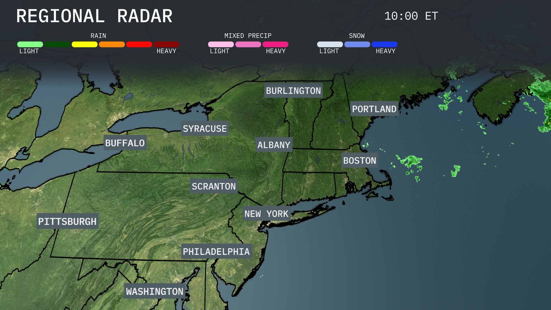
The Northeast Regional Radar shows mainly clear conditions with some light rain showers approaching coastal areas, including Portland. Albany and Syracuse are currently free from precipitation, enjoying clear skies. New York City, Philadelphia, and Boston remain dry as well, with no significant weather systems impacting these urban centers at this time. Meanwhile, light showers off the coast are moving towards Portland but have yet to bring substantial rainfall to the mainland.
Tomorrow morning in New York City, temperatures start at 54 degrees with partly cloudy skies. By 11 AM, expect temperatures to rise to 58 degrees with winds picking up, gusting to around 15 miles per hour from the northwest. The morning will remain mostly dry, providing a cool and breezy start to the day.
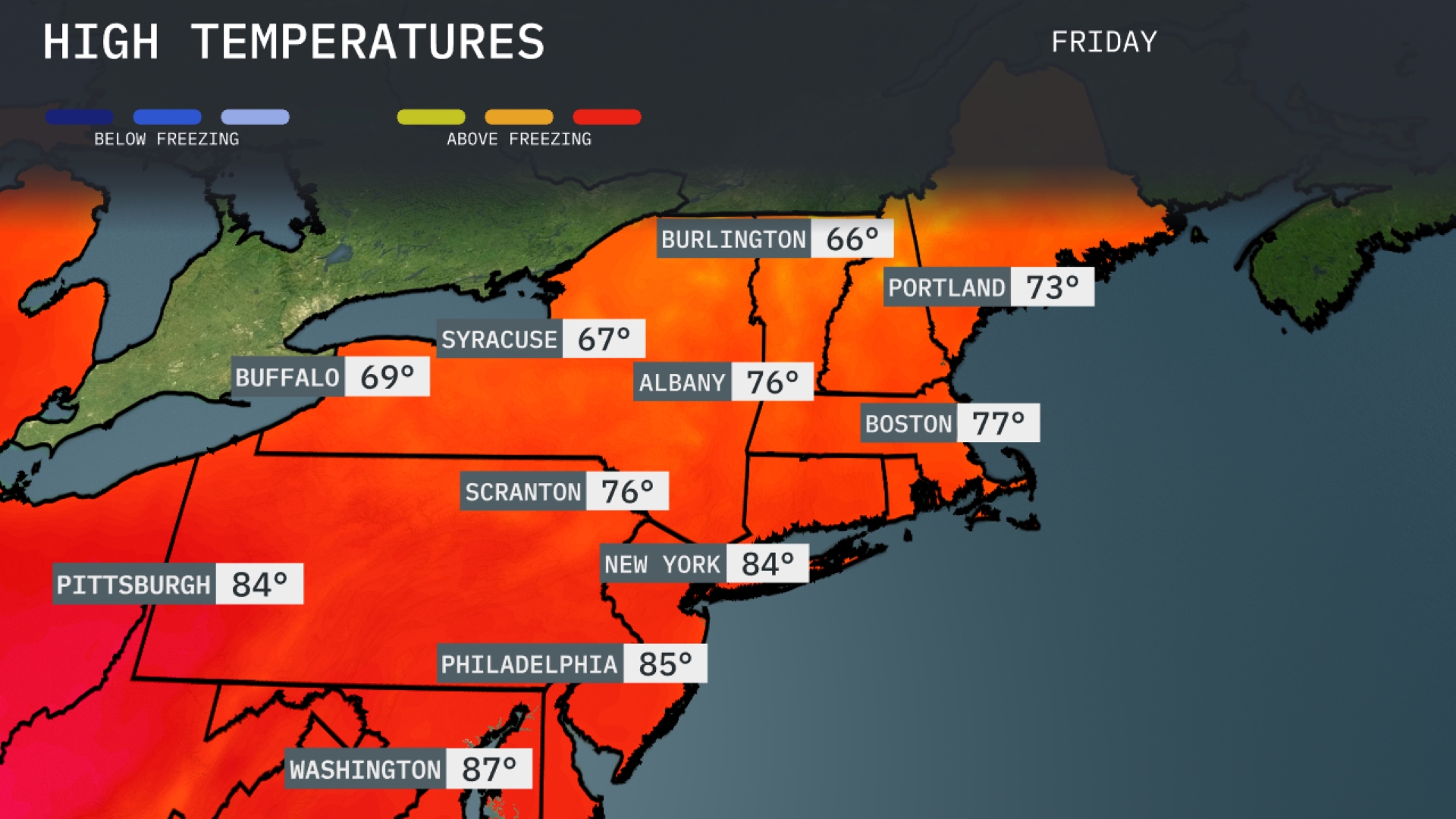
Tomorrow in the Northeast, temperatures will be unseasonably warm for mid-September. New York City is expected to reach a high of 84 degrees, while Philadelphia will top out at 85 degrees. Boston is forecasted to hit 77 degrees, alongside Albany at 76 degrees, both well above average for this time of year. Pittsburgh will also see warm conditions with a high of 84 degrees. This warmth is influenced by a dominant high-pressure system bringing steady, clear skies across the region.
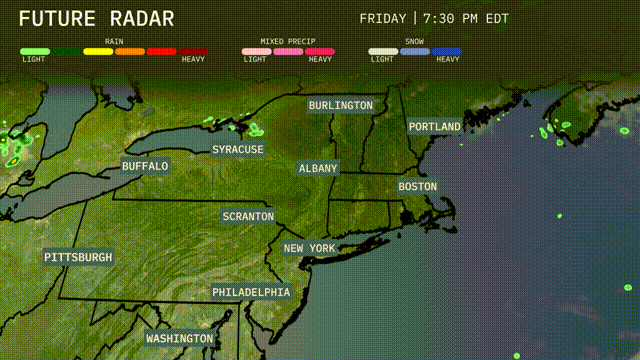
A high-pressure system will maintain mostly clear conditions across the Northeast, with warmer temperatures pushing slightly above average, particularly around New York City and Boston. Showers are expected to develop over parts of northern New York and Vermont by late afternoon due to a weak disturbance. Moderate rain may impact travel in these areas during the evening commute. Coastal regions from Portland to Boston could experience isolated showers but will generally remain dry. No severe weather is anticipated, allowing for a calm start to the midweek.
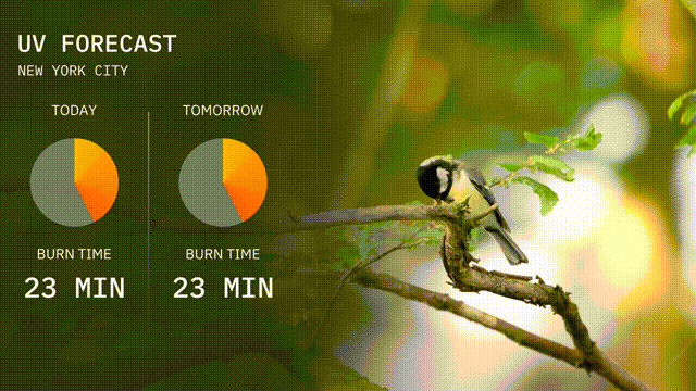
The UV index in New York City today and tomorrow is 6, suggesting moderate sun exposure. Burn time is approximately 23 minutes in direct sunlight, so be sure to use sun protection. Enjoy your time outdoors, but remember to be sun smart!
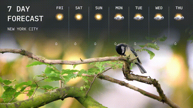
For the 7-day forecast in New York City:
Friday: Expect sunny skies with a high of 77 degrees and a low of 59 degrees.
Saturday: Sunshine continues with temperatures peaking at 81 degrees and dipping to 61 degrees.
Sunday: The sun remains, with a high of 82 degrees and a nighttime low of 62 degrees.
Monday: Partly cloudy with a high of 78 degrees and a low of 60 degrees.
Tuesday: More clouds than sun, with highs around 76 degrees and lows near 58 degrees.
Wednesday: Partly cloudy skies will persist, as temperatures reach a high of 75 degrees and cool down to 57 degrees.
Thursday: Continue to expect partly cloudy conditions, with a high of 74 degrees and a low of 56 degrees.