A complete rundown of the shifting skies over NYC and the Northeast – from morning mildness to evening chills. Get the full forecast for a head start on your day!
Expect a balanced morning in NYC with temps rising gently under a cloudy sky. By noon, the sun makes a shy appearance as we reach a pleasant 73°F. A calm start to what promises to be an engaging week in weather!
Your detailed guide to NYC’s weather: Starting off with a cloudy Thursday morning at a comfy 68°F, and escalating to a mild 73°F by noon with light south winds. This also includes an update on expected storms and heavy rain across other Northeast cities setting the scene for a volatile Friday. On a safety note, the UV index hits a high of 9, so pack your sunscreen. Wrapping up, your week’s outlook from cloudy days to showers, with temperatures fluctuating pleasantly.
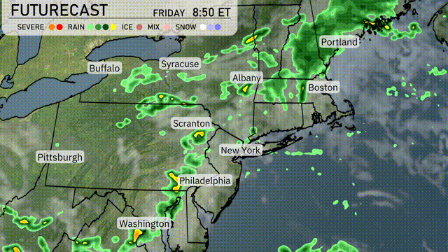
On the Regional Radar, a significant line of storms is sweeping through the eastern side of Pittsburgh, moving northeast toward Scranton. Meanwhile, heavy rain showers are making their way through Syracuse, with pockets of intense precipitation indicated. Buffalo is seeing scattered rain showers as well, but the system is shifting eastward. In the northeast, Portland is experiencing rain, while Boston reports cloudy skies with light precipitation, indicating a more settled weather pattern.
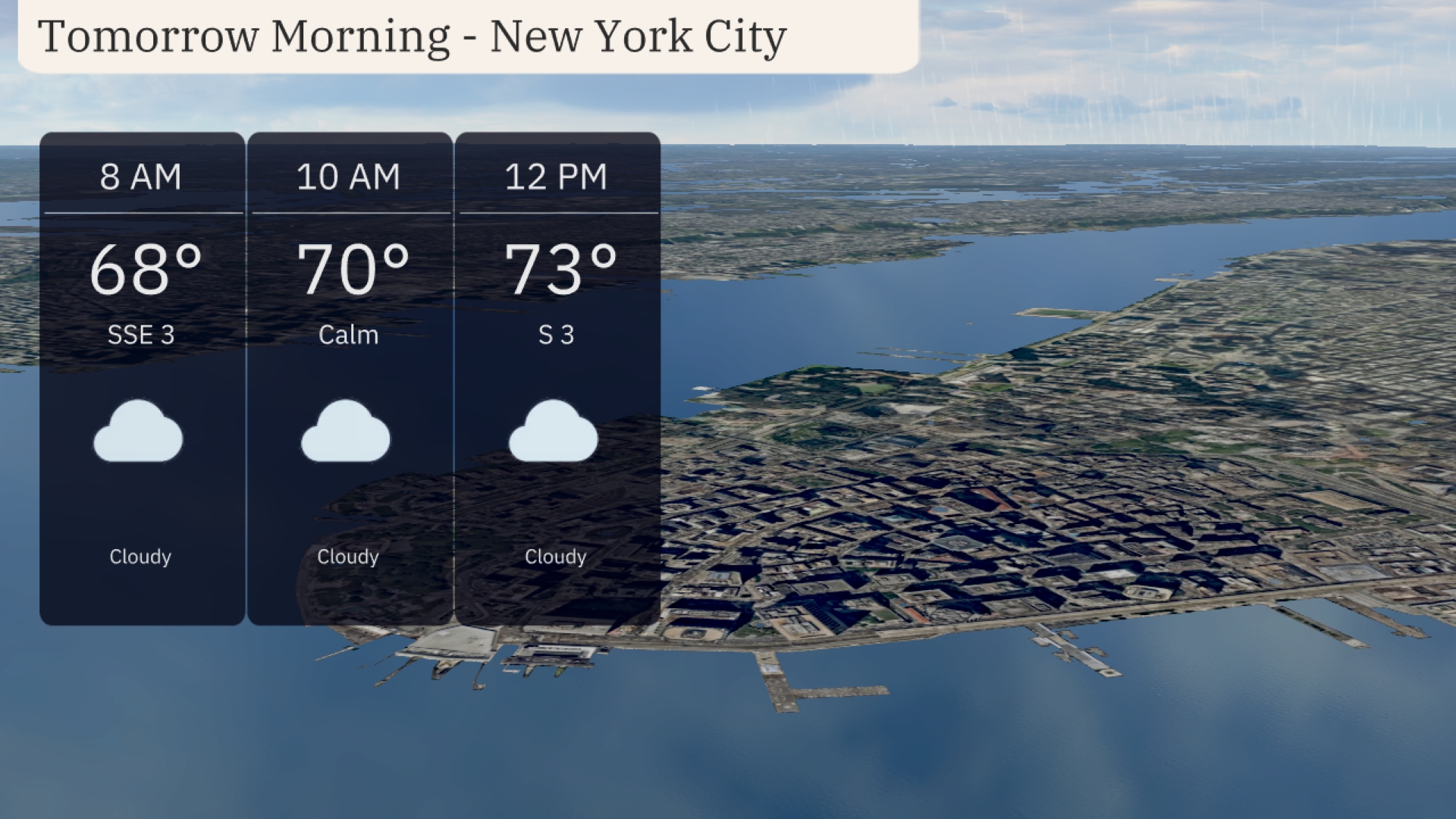
New York City tomorrow morning starts off cloudy with temperatures at 68 degrees by 8 AM. A calm and mild morning continues as temperatures rise to 70 degrees at 10 AM, maintaining cloud cover throughout. By noon, expect it to reach 73 degrees with light south winds at 3 mph. A steady and calm morning for the city with no wild weather swings in sight.
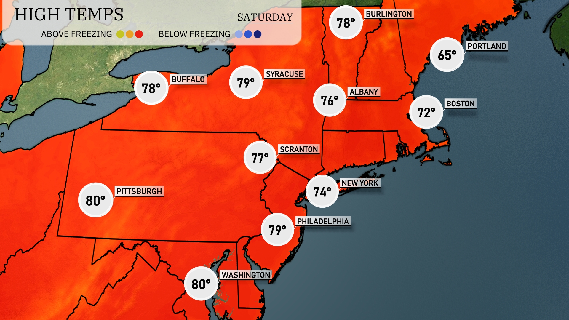
Tomorrow in the Northeast, Pittsburgh is set to hit an impressive high of 80 degrees, while Washington, D.C. will match that warmth. Philadelphia will see a high around 79 degrees, and Scranton is forecasting 77 degrees. New York City can expect a comfortable 74 degrees, with Albany slightly cooler at 76. Meanwhile, Boston will be on the lower end with a high of 72 degrees, while Portland remains chilly at 65 degrees—all readings above seasonal averages reflecting the influence of a warm front moving through the region.
Friday ushers in an active weather pattern across the Northeast as a cold front sweeps through. Expect scattered thunderstorms from Philadelphia to Boston, with the potential for some storms to turn severe, particularly around noon. Heavy rain and gusty winds could impact the commute in and around New York City. By evening, showers linger over northern New England, cooling temperatures slightly. Stay alert for potential flash flooding in low-lying areas as significant rainfall accumulates over the next 24 hours.
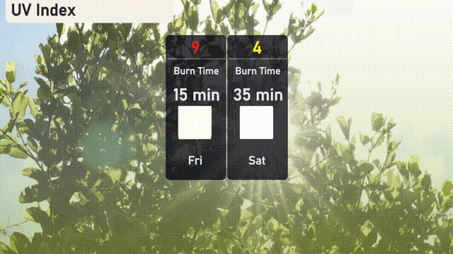
The UV index in New York City on Friday stands at a high of 9, with a potential burn time of just 15 minutes, so be sure to protect your skin. By Saturday, it will drop to a moderate level of 4, allowing for a more leisurely burn time of 35 minutes.
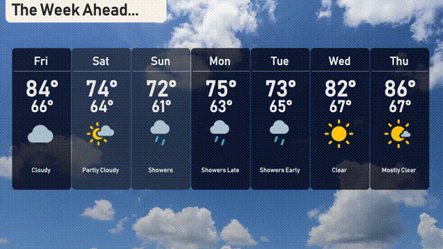
Friday: Cloudy skies with temperatures reaching a high of 84 degrees and a low of 66 degrees.
Saturday: Partly cloudy conditions with a bit of sun, expect a high of 74 degrees and a nighttime low of 64 degrees.
Sunday: Showers expected throughout the day with temperatures peaking at 72 degrees and dipping to 61 degrees.
Monday: Showers late in the evening, with a daytime high of 75 degrees and a low of 63 degrees.
Tuesday: Early showers are on the forecast, with temperatures reaching up to 73 degrees and a low of 65 degrees.
Wednesday: Clear skies are on deck, with a high of 82 degrees and a low of 67 degrees.
Thursday: Mostly clear as temperatures soar to a high of 86 degrees and a low of 67 degrees.
Hope that helps, and have a fantastic week!