NYC Weather This Week: From Scorching Heat to Cooling Showers
By
Amy Freeze
Explore this week's dynamic weather in NYC — from heat waves peaking at 97°F to refreshing rainfalls cooling down the evenings.
This week, NYC experiences a roller-coaster of temperatures with sizzling highs and soothing rain showers. Get the full forecast!
Get ready, New York! This week you’ll be riding a temperature roller-coaster. With highs soaring up to 97 degrees and nightly lows down to the mid-60s, each day brings a new surprise. Rain showers and thunderstorms are expected by the weekend, ensuring a refreshing break from the heat. Don’t miss out on our detailed day-by-day forecast at https://amyfreeze.ai/. Packed with tips to beat the heat and stay dry!
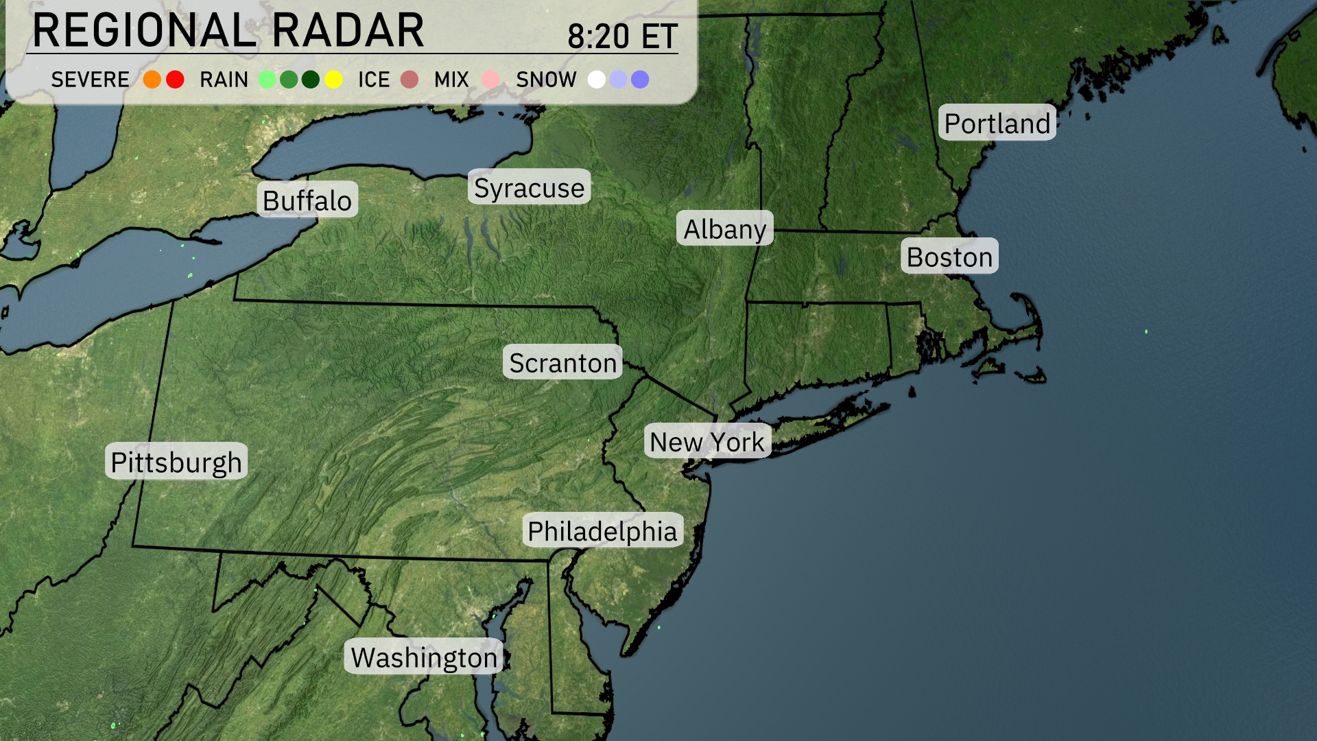
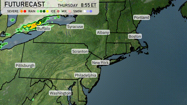
The Northeast is mostly clear at the moment. Rain is moving into the region, with showers developing over Syracuse and heading towards Albany. Cloud cover is increasing over the New York City area, with the possibility of rain developing later. Buffalo and Scranton remain dry for now.
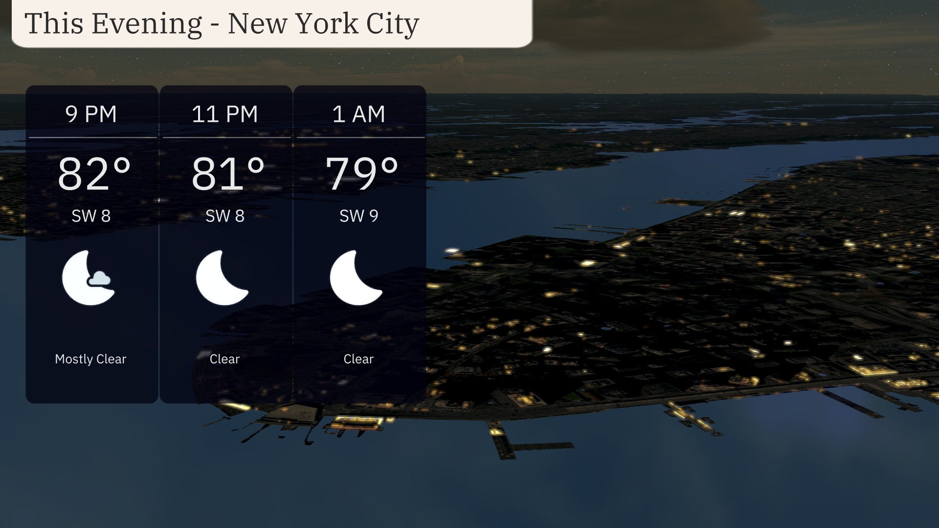
This evening in New York City, temperatures will trend from 82 degrees at 9 PM to 79 degrees by 1 AM. Expect mostly clear skies through the evening, offering a beautiful view of the night. Winds are coming from the southwest, maintaining a light breeze at 8 to 9 miles per hour. A clear and calm night ahead as high pressure dominates the area.
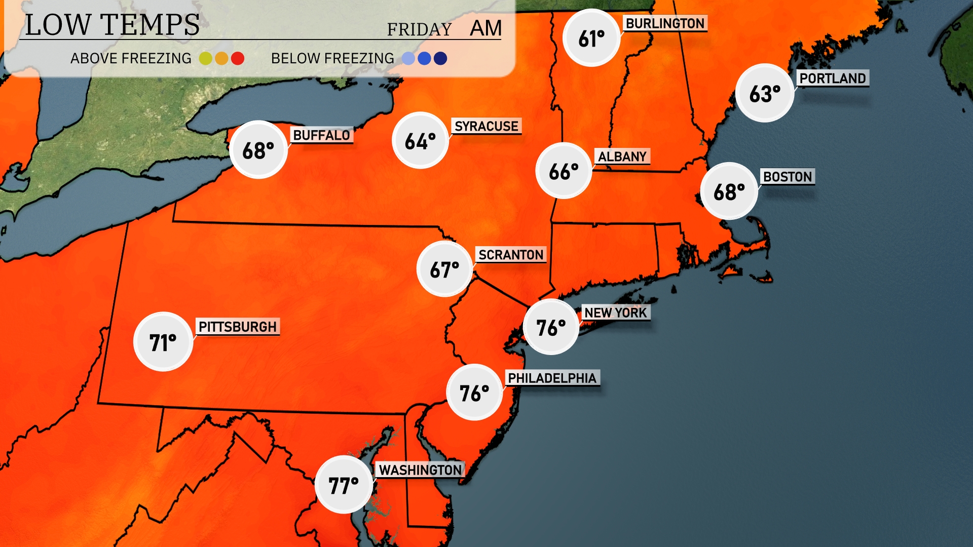
Tonight, low temperatures across the Northeast will see notable drops. New York City will dip to 76 degrees, while Philadelphia also hits a low of 76. In Scranton, expect a cooler night with temperatures dropping to 67 degrees. Buffalo will finish the night at 68 degrees, and Boston will cool down to 63.
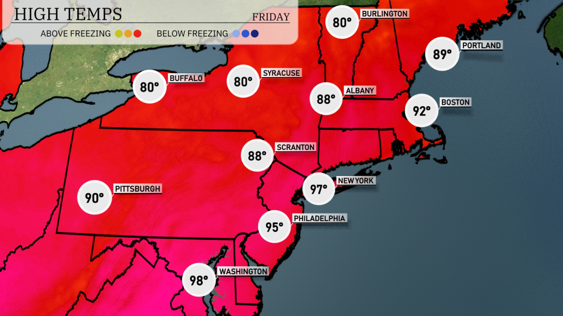
Tomorrow, high temperatures in the Northeast are expected to soar significantly, with New York City reaching 97 degrees and Philadelphia hitting 95 degrees. Boston isn’t far behind, set to warm up to 92 degrees, while Albany and Scranton both anticipate highs around 88 degrees. Buffalo and Syracuse will also see pleasant conditions with highs of 80 degrees. This heat wave is pushing temperatures well above average for this time of year, largely influenced by a strong ridge of high pressure settling over the region.
An approaching cold front brings rain showers to the Northeast, starting late Thursday evening near Buffalo and stretching towards Syracuse, Albany, and into Boston by morning. Expect localized heavy rainfall, particularly in western New York, with potential for isolated thunderstorms. Precipitation diminishes as the front moves eastward, reaching New York City, Scranton, and Philadelphia by late Friday. Temperatures will drop slightly behind the front, offering cooler air right into the weekend. Stay prepared for possible travel delays due to wet roads and reduced visibility.
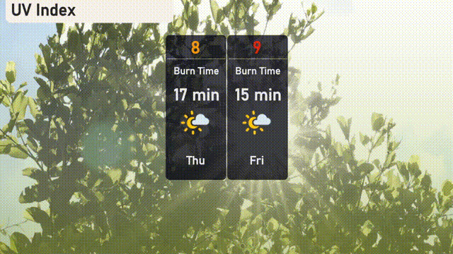
The UV index in New York City will reach a high of 8 today, with a burn time of approximately 17 minutes in direct sunlight. Tomorrow, the index increases to 9, reducing the burn time to about 15 minutes. Wear broad-spectrum sunscreen, seek shade during peak hours, and protect your skin with clothing and hats.
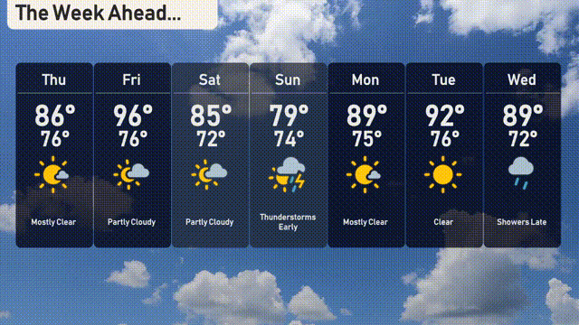
For the 7-day forecast in New York City:
Thursday: Mostly clear skies with a high of 86 degrees and a low of 76 degrees.
Friday: Warm temperatures continue with partly cloudy conditions, reaching up to 96 degrees and cooling down to 76 degrees.
Saturday: Expect partly cloudy weather, the temperature peaking at 85 degrees and a low around 72 degrees.
Sunday: Early thunderstorms are likely, leading to a high of 79 degrees and a low of 74 degrees.
Monday: Mostly clear skies return, with temperatures hitting a high of 89 degrees and a nighttime low of 75 degrees.
Tuesday: Clear and sunny with a high of 92 degrees and a low of 76 degrees.
Wednesday: Showers are expected late; high temperatures will reach 89 degrees, with a low of 72 degrees.