From Thunderstorms to Sizzling Heatwaves: Your Weekly NYC Weather Forecast
By
Amy Freeze
Experience the dynamic shifts in New York City's weather this week, from intense thunderstorms to extreme heatwaves. Stay prepared with our comprehensive guide.
Explore the drastic weather changes in NYC this week, from thunderstorms to heatwaves. Don’t miss our tips on how to stay safe!
This week in NYC, the weather takes us on a wild ride from thunderstorms to alarming heatwaves. Our detailed forecast traces the development of storm systems across the Northeast and predicts a spike in temperatures that could lead to heat-induced advisories. We delve into day-by-day predictions, offering insights into how these weather conditions could affect your daily routines and safety measures. For a detailed daily breakdown and expert tips, visit our blog at https://amyfreeze.ai/nyc-weather-thunderstorms-to-heatwaves.
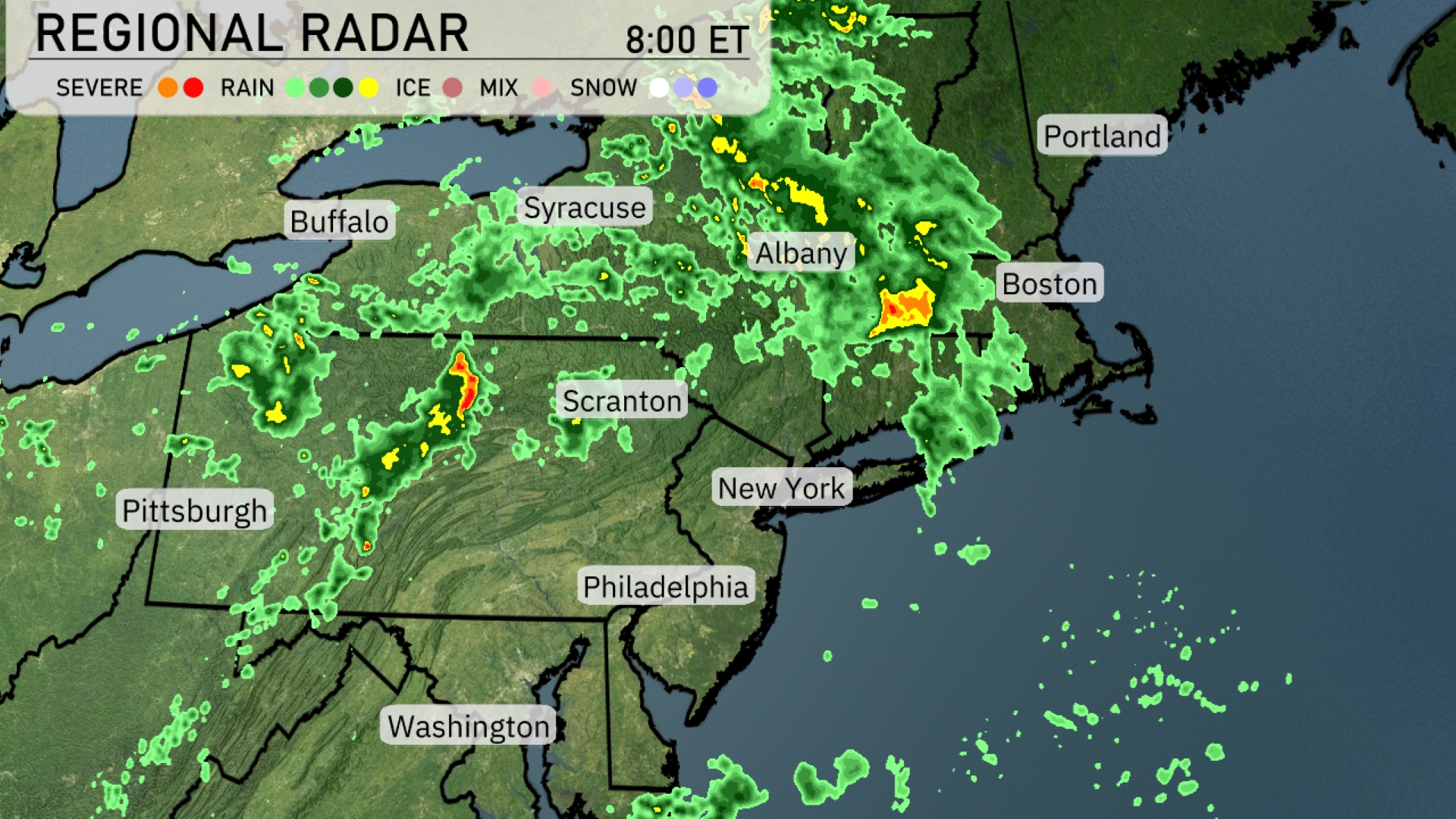
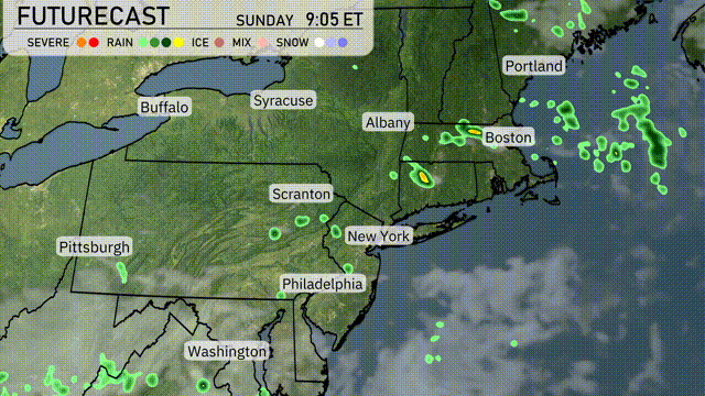
On the Regional Radar, showers and thunderstorms extend from western Pennsylvania up through central New York, drifting eastward towards Albany and Boston. Significant rainfall is affecting areas around Syracuse, with heavier patches south of Albany. There’s a notable thunderstorm cell over the Boston area, which could bring strong winds and heavy rain. Cloud cover is prevalent across the entire Northeast, with more isolated showers near Pittsburgh.
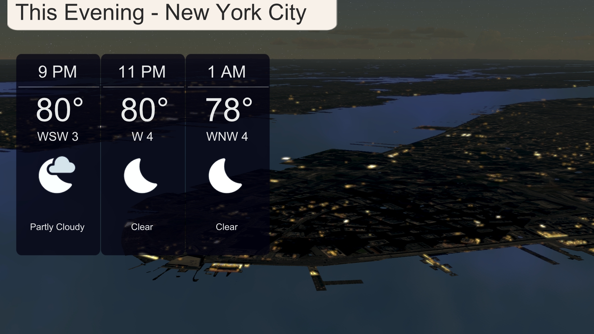
This evening in New York City, temperatures will remain warm, holding at 80 degrees by 9 PM and dropping slightly to 78 degrees by 1 AM. Expect partly cloudy skies turning clear as the evening progresses. Winds will be light, shifting from west-southwest at 3 miles per hour to west-northwest at 4 miles per hour.
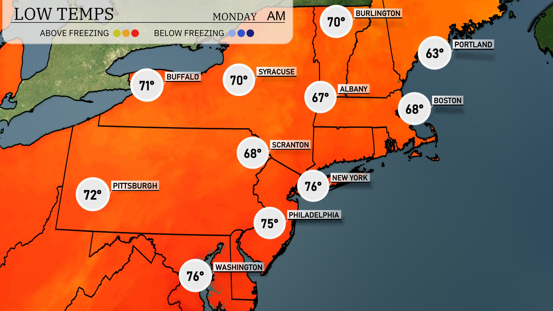
Tonight, Buffalo is expected to drop to 71 degrees, while Syracuse will cool off to 70. Scranton sees a more considerable dip, reaching 68 degrees, with New York not far behind at 67. Boston will experience the evening at 63 degrees, marking a notable drop from earlier temperatures.
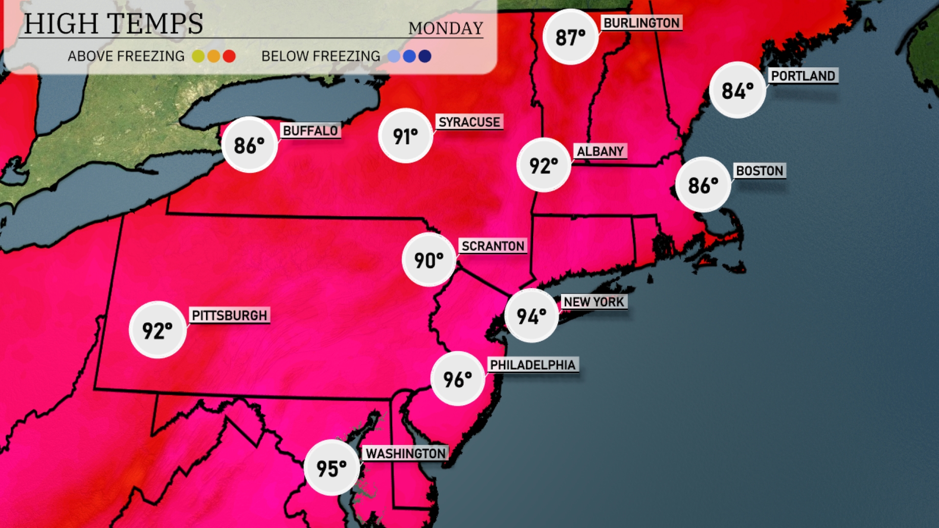
Tomorrow, high temperatures in the Northeast will soar, with Philadelphia reaching a heatwave-inducing 96 degrees. New York City isn’t far behind at 94 degrees, while Scranton will hit 90. Notably, temperatures in Pittsburgh will also be warm at 92 degrees, marking above-average readings across the region. Syracuse will see a high of 91 degrees, further contributing to the trend of unseasonably warm weather as high pressure dominates, providing clear skies and sunshine.
A series of showers and thunderstorms will sweep through the Northeast by tomorrow afternoon. Areas from Albany to Boston can expect stormy weather, with the potential for heavy rain and localized flooding. Temperatures will remain comfortably in the upper 70s, but keep an eye out for gusty winds and lightning within the storm cells. The weather system will gradually clear by Wednesday morning, bringing back drier and more pleasant conditions. Please stay alert for any updates or warnings if you’re in the affected areas.
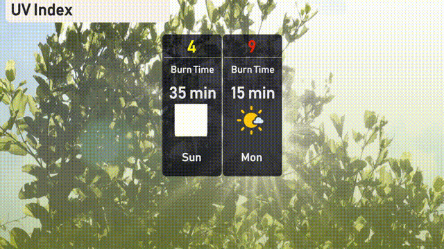
The UV index in New York City will be moderate at 4 on Sunday, with a 35-minute burn time in direct sunlight. By Monday, the index is expected to rise significantly to 9, reducing burn time to just 15 minutes. It’s wise to use sunscreen and seek shade during peak sun hours!
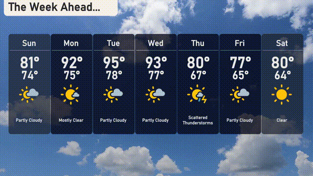
For the 7-day forecast in New York City:
Sunday: Partly cloudy with a high of 81 degrees and a low of 74 degrees.
Monday: Mostly clear skies and warmer, reaching a high of 92 degrees and a low of 75 degrees.
Tuesday: Heat continues with a peak of 95 degrees, cooling slightly to 78 degrees overnight.
Wednesday: More partly cloudy skies, high of 93 degrees, low of 77 degrees.
Thursday: Expect scattered thunderstorms with temperatures hitting 80 degrees and dropping to 67 degrees.
Friday: Partly cloudy, with a high of 77 degrees and a low around 65 degrees.
Saturday: Clear conditions return as the highs reach 80 degrees and lows settle at 64 degrees.
Hope that helps, stay safe!