NYC’s Weather Whiplash: Calm Nights to Stormy Days Ahead
By
Amy Freeze
Explore the dynamic weather shifts hitting New York City and the Northeast, from serene evenings to stormy mornings, with insights from Meteorologist Amy Freeze.
New York City’s weather is taking a dramatic turn. From the serene evenings to the upcoming stormy days, Amy Freeze guides you through what to expect in the Northeast.
Greetings from Amy Freeze, your trusted meteorologist, with a detailed forecast for New York City and the Northeast. As the skies partly clear tonight, a wave of inclement weather is making its way through the region. With temperatures varying across cities and a cold front pushing through, our weather is as dynamic as ever. Get the full forecast for the next seven days, including tips on how to stay prepared during these shifting weather patterns, on our detailed blog at https://amyfreeze.ai/
A wave of rain is sweeping across the Northeast, with heavier showers stretching from New York City through Albany and into New England. Thunderstorms are affecting areas just east of New York City, brushing the coastal regions of Long Island. Moving up along the 95 corridor, you can find scattered showers reaching into Providence and Boston. Meanwhile, light rain is spotted around Syracuse, reaching into southern Buffalo, with clearing skies expected behind the front. Those in Portland and across the northern borders should anticipate increasing cloud cover as the system progresses eastward.
As we head into the evening hours in New York City, expect temperatures holding steady at 61 degrees from 9 PM to 11 PM with a southeast breeze. A few showers are possible around 9 PM, transitioning to mostly cloudy skies by 11 PM. By 1 AM, temperatures will dip slightly to 59 degrees, with conditions turning calm and fog likely developing.
Tonight in the Northeast, the region to experience a cold air push. In Boston, a low of 55 degrees is on tap, while Albany will feel the chill at 52. Syracuse is forecasting a cooler 48 degrees, with Buffalo close behind at 46. Scranton will settle at 54 degrees, and Philadelphia will hang at 58.
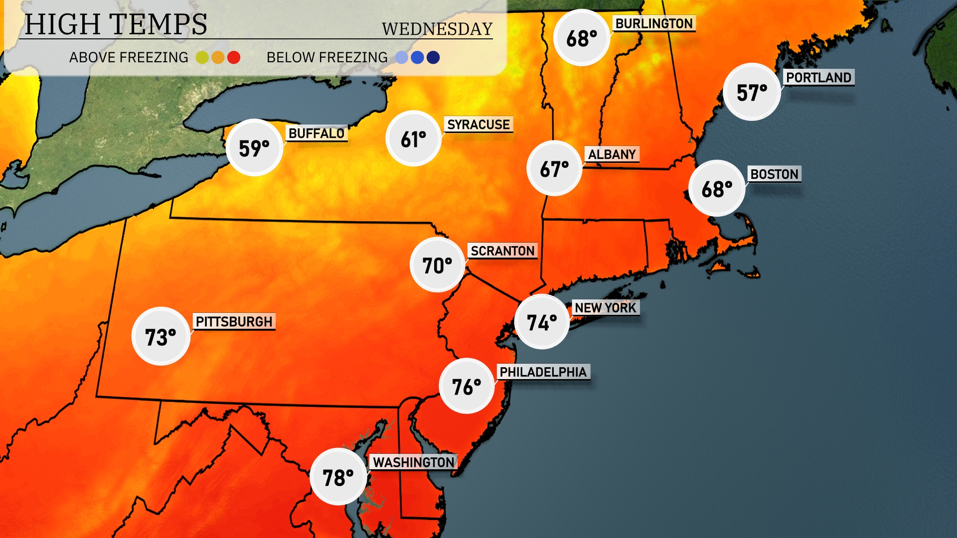
Tomorrow in the Northeast, temperatures are expected to be pleasantly warm, with several cities experiencing above-average highs. New York City will reach 74 degrees, while Philadelphia is projected at 76 degrees. Pittsburgh will also enjoy mild weather at 73 degrees, and Scranton is set for a comfortable 70. Buffalo, however, will be cooler at 59 degrees, which is below the norm.
A front is pushing through the Northeast, bringing widespread rain showers from Pennsylvania to Maine, with heavier pockets expected around Syracuse and Albany. Areas from Philadelphia to New York City will see showers, possibly impacting the evening commute. Expect a bit of clearing late evening, but keep umbrellas handy. Temperatures will be cooler behind the front, with afternoon highs dropping into the low 60s. As the system moves east, watch for lingering showers near the coast, particularly around Boston, early tomorrow.
The UV index in NYC will be low on Tuesday with a value of 3, as a storm system is moving through, reducing sun exposure. By Wednesday, expect a high UV index of 7, with a burn time of approximately 20 minutes. Make sure to use sunscreen and wear protective clothing if you’re out and about.
For the 7-day forecast in New York City:
Tuesday: Morning showers with highs reaching 64 degrees and a low of 57.
Wednesday: Partly cloudy, warming up to 73 degrees during the day, cooling to a low of 59.
Thursday: Rain is expected with a high of 74 degrees and lows around 54.
Friday: Partly cloudy skies, cooler with highs at 59 degrees and a nighttime low of 52.
Saturday: Mostly clear conditions, high of 72 degrees and lows settling at 56.
Sunday: Another mostly clear day, temperatures peaking at 77 degrees and a low near 57.
Monday: Partly cloudy with temperatures topping out at 73 degrees and a low of 59.