From Clear Nights to Stormy Mornings: NYC’s Comprehensive Weather Forecast
By
Amy Freeze
Dive into our detailed weather predictions from Meteorologist Amy Freeze to smoothly navigate through New York City’s varying climate—from peaceful evenings to stormy forecasts.
Tonight, enjoy clear skies in NYC with predictions of showers heading our way! Get all your weather details here.
Meteorologist Amy Freeze here with your Northeast Forecast update. As NYC enjoys a crisp evening, be prepared for a line of storms impacting from Maine to Boston. We’ll see a variety of conditions across the region, with detailed temperature drops and an impending coastal storm threatening with heavy rains and strong winds. Check out our full analysis and stay prepared with our weather insights.
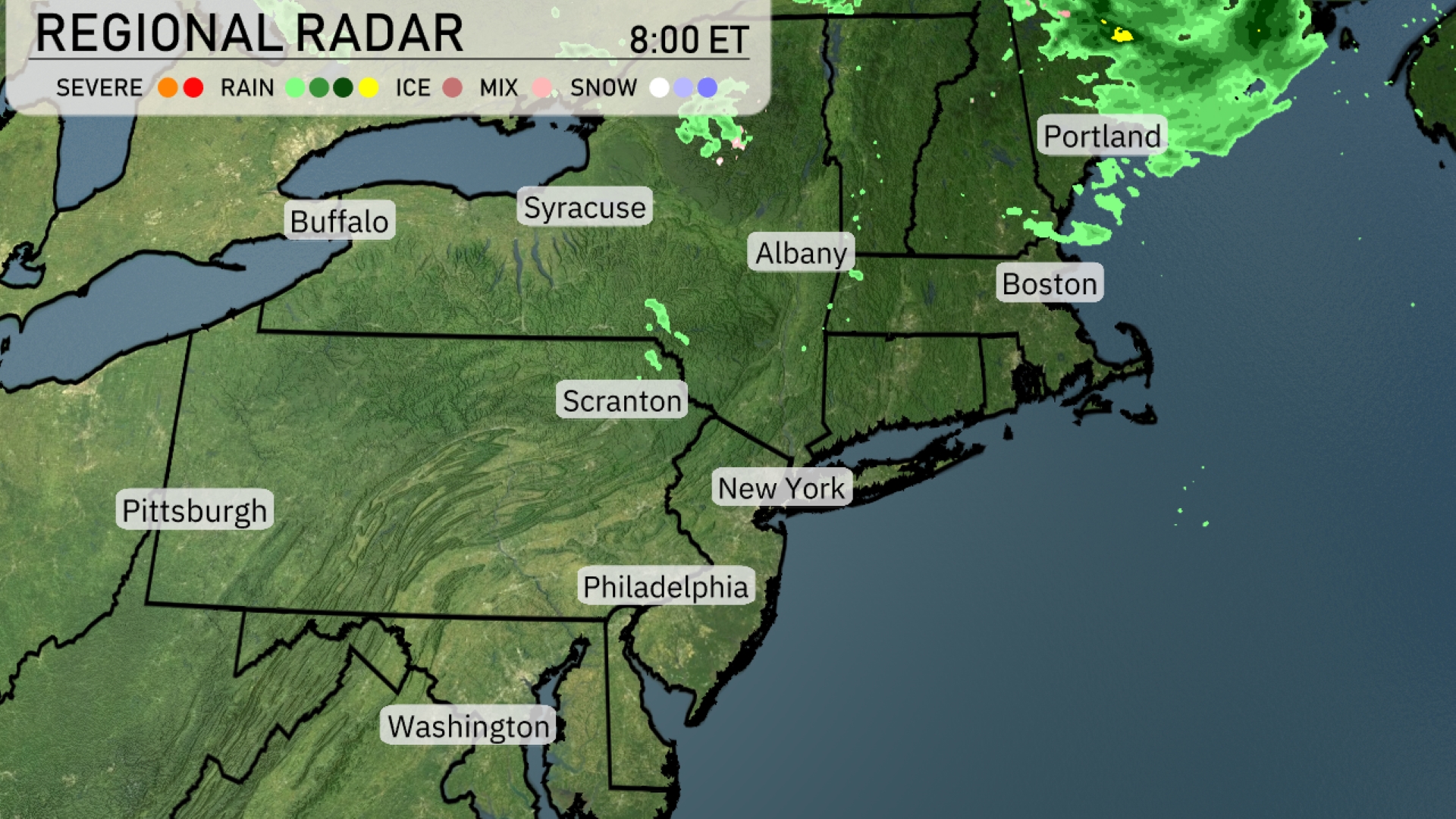
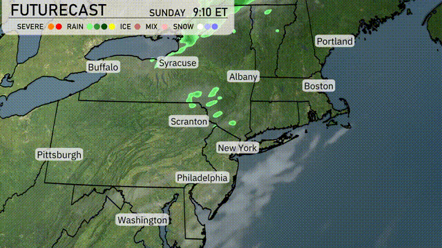
A line of rain showers is sweeping across portions of Maine, stretching from the Canadian border down towards Portland. Boston is enjoying clear skies as the precipitation stays to the north. Albany is on the edge of the clouds, while Syracuse and Buffalo remain dry under sunny spells. Light rain is moving out of the Scranton area, drifting farther northeast. Philadelphia and New York maintain clear and calm conditions as the systems pass to their north.
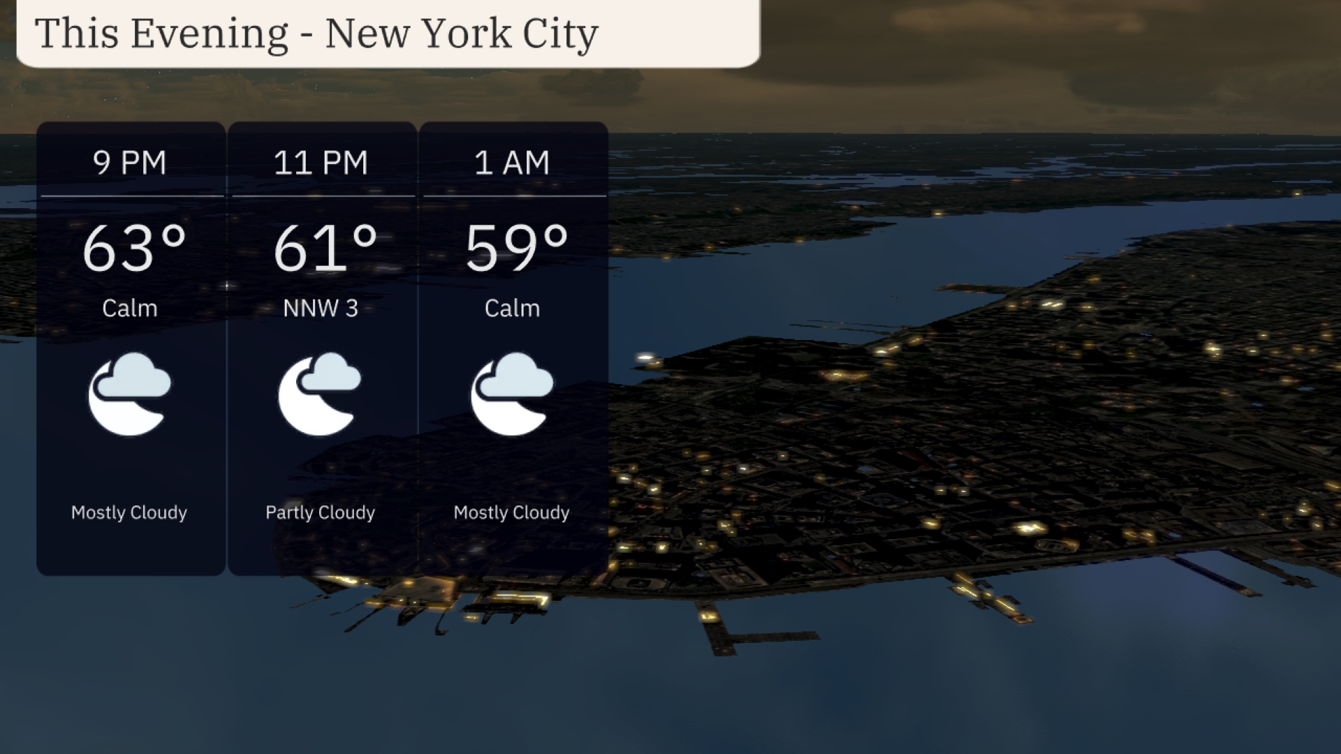
As the evening unfolds in New York City, expect mostly cloudy skies. Temperatures will drop gradually from 63 degrees at 9 PM to 59 degrees by 1 AM. Winds will remain light, with a brief shift to the northwest at 3 miles per hour around 11 PM.
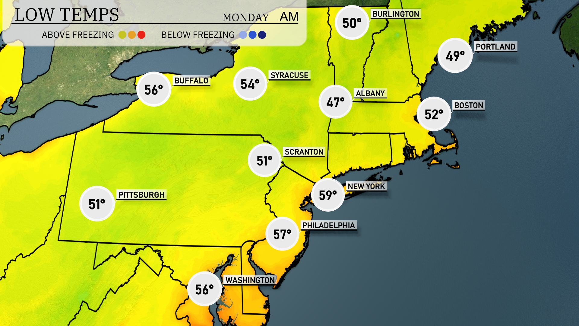
Tonight New York City can expect a low of 59 degrees, while Philadelphia will see a mild 57. Scranton drops to 51, and farther north, Albany will chill to 47 degrees. Boston’s low will register at 52, but Portland gets even cooler at 49 degrees. Expect the overnight temperatures to feel cool, particularly in western Pennsylvania, where Pittsburgh will settle at 51 degrees.
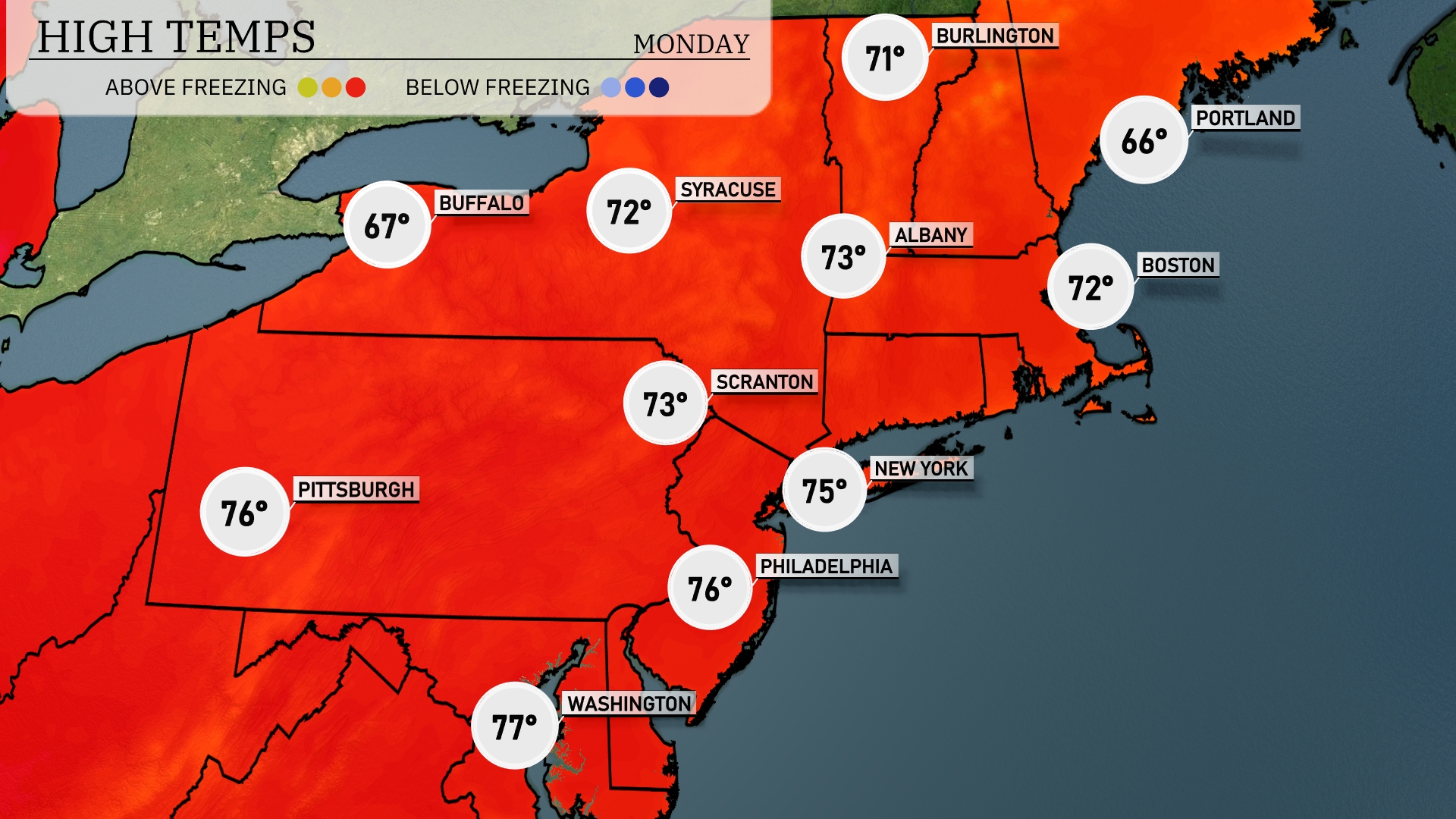
Tomorrow New York City is predicted to hit 75 degrees, while Philadelphia will be slightly warmer at 76 degrees. Scranton and Albany will see highs of 73 and 73 degrees, respectively. Buffalo is expected to reach a comfortable 67 degrees, and Boston will have a high of 72 degrees.
A coastal storm is expected to impact the Northeast, moving into areas from New York to Boston. Rainfall begins early in the morning and intensifies throughout the day, with potential for localized flooding, especially in urban areas. Winds will be strong along the coast, potentially reaching 30-40 mph, and higher gusts could lead to coastal erosion concerns. Temperatures will remain in the mid to upper 60s, providing a cooler setting under overcast skies. Watch for clearing toward Wednesday as the system moves out to sea, bringing drier and more pleasant conditions.
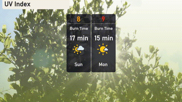
The UV index for New York City on Sunday is high at 8, with a burn time of about 17 minutes under direct sun. As we move into Monday, anticipate an even higher UV index of 9, reducing the burn time to just 15 minutes!
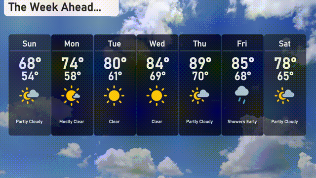
Sunday: Partly cloudy with a high of 68 degrees and a low of 54.
Monday: Enjoy mostly clear skies, with temperatures reaching up to 74 degrees and dipping to 58 at night.
Tuesday: Sunny skies all day, with a delightful high of 80 degrees and a low of 61.
Wednesday: It’s clear and warming up nicely to a high of 84 degrees, cooling to 69 overnight.
Thursday: Partly cloudy with a warm high of 89 degrees, low near 70.
Friday: Expect showers early, then partly cloudy conditions, with a high of 85 degrees and a low of 68.
Saturday: Partly cloudy with a pleasant high of 78 degrees and a low of 65.