Chilly Blasts and Sunny Spells: Navigating NYC’s Dynamic Weather Pattern
By
Amy Freeze
Explore the ebb and flow of New York City's weather as Meteorologist Amy Freeze provides vital updates and insights into the fluctuating temperatures and storm systems moving across the Northeast.
As NYC oscillates between serene skies and stormy forecasts, Meteorologist Amy Freeze offers her expert insights to help you stay prepared. Click for more detailed coverage!
Dive deeper into New York City’s dynamic weather landscape with thorough analyses from Meteorologist Amy Freeze. From serene, clear evenings to urgent storm warnings and the detailed 7-day forecast, get the insights you need to navigate your week. Click here to read more: https://amyfreeze.ai/
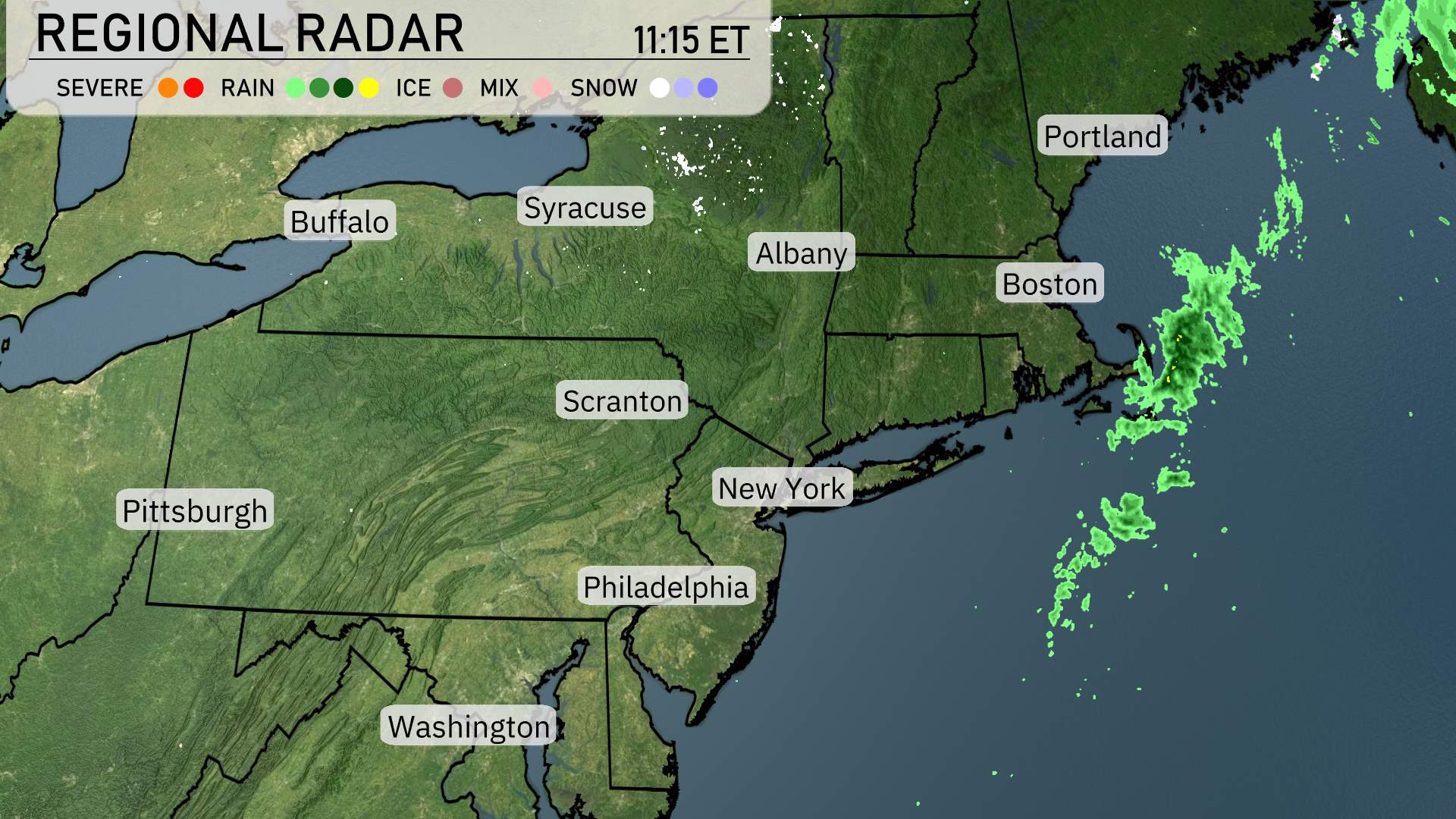
In the Northeast, radar imagery indicates largely calm conditions with clear skies dominating much of the region. However, there’s some precipitation being detected offshore of New England, likely impacting parts of coastal areas near Boston as clouds and light rain linger just offshore. Moving across upstate New York, including cities like Albany and Syracuse, skies remain predominantly clear, enhancing a pleasant weather outlook for the day. In contrast, the northernmost sections near Buffalo are experiencing some cloud cover, but without significant precipitation. Farther south, Philadelphia is enjoying clear skies, while Washington D.C. holds similar conditions, setting up for a day with ample sunshine across the metropolitan areas.
For this evening in New York City, expect clear skies with temperatures gradually dropping from 46 degrees at 8 PM to 41 degrees by midnight. Winds will remain light, shifting from northwest at 5 mph to north at 6 mph as the night progresses.
Tonight, the Northeast is bracing for a significant drop in temperatures. Boston will see a chilly low of 33 degrees, while Portland can expect a frigid 30 degrees. Philadelphia will cool down to 44 degrees. Scranton is looking at a low of 39. Further inland, Syracuse will drop to about 39 degrees, and Albany will be colder at 37. The cold air mass settling over the region will make for a brisk start to the day tomorrow.
Tomorrow’s high temperatures in the Northeast are shaping up to be quite variable, with readings below average in many areas.
Buffalo reaches a chilly 47 degrees, while Syracuse isn’t much warmer at 48. Scranton also logs a high of 47 degrees. New York City will reach 47 degrees, as well. Albany expects a high of 49 degrees, and over in Boston, temperatures climb to just 41 degrees.
Philadelphia sees a slight uptick with a high of 54 degrees, while Pittsburgh stands out as the warm spot with a notable high of 64 degrees. Overall, a cool air mass continues to linger, contributing to these below-average temperatures across much of the region.
On the Northeast futurecast, expect an impactful day of weather with shifting patterns. A low-pressure system is set to bring widespread rain across the region, especially affecting cities from Syracuse to Boston through tomorrow. Heavy rain may lead to localized flooding, particularly in urban areas by the late evening. The Storm Prediction Center has placed eastern New York and northern New Jersey in a slight risk for severe thunderstorms that could produce strong, gusty winds and isolated flash flooding.
As the day progresses, watch for declining visibility and potential travel delays, especially during the morning commute. Rainfall totals could surpass one inch, with the most intense weather expected throughout the day. Temperatures will remain steady, hovering in the low 60s, as the system moves farther eastward into coastal areas by Wednesday morning. Be prepared for brisk winds as the cold front approaches, ushering in a more cool, dry air mass that will clear the skies by Thursday.
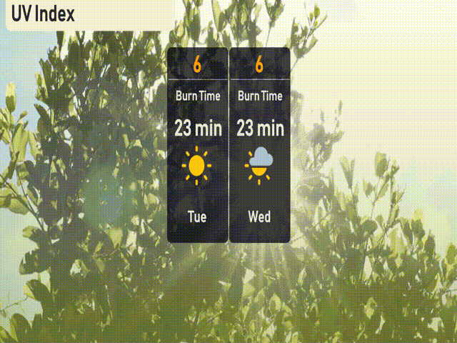
The UV index in New York City will be a moderate 6 on both Tuesday and Wednesday. Expect a burn time of about 23 minutes if you’re soaking up the sun. Remember, the sun can be deceivingly strong even on days with partial cloud cover, so don’t forget that sunscreen and your favorite sun hat!
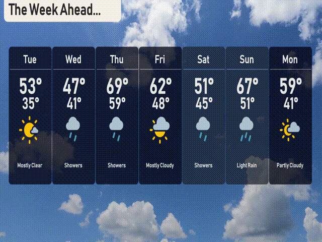
Here’s the 7-day weather outlook for New York City:
Tuesday: Enjoy mostly clear skies with a high of 53 degrees and a nighttime low of 35 degrees.
Wednesday: Expect showers throughout the day, with temperatures peaking at 47 degrees and dipping to 41 at night.
Thursday: Showers continue, bringing a warmer high of 69 degrees with a low around 59 degrees.
Friday: Mostly cloudy skies with a high of 62 degrees and a low of 48.
Saturday: The cooler trend resumes with light rain expected, highs of 51 degrees, and overnight lows of 45.
Sunday: Look out for showers along with a high of 67 degrees and a low of 51 degrees.
Monday: Partly cloudy conditions with highs reaching 59 degrees and a nighttime low of 41.
Stay safe and have a wonderful week ahead!