Navigating Through NYC’s Dynamic Weather: A Week of Sun, Showers, and Storms
By
Amy Freeze
Explore a detailed weather forecast with Meteorologist Amy Freeze as New York City experiences everything from sunny clear skies to stormy evenings. Perfect for planning your week ahead!
This week, NYC and the Northeast are on a rollercoaster ride weather-wise! Expect everything from sunny days reaching up to 86 degrees to stormy nights with heavy downpour. Meteorologist Amy Freeze breaks down what to expect each day.
Join Meteorologist Amy Freeze as she outlines a detailed forecast for New York City and the broader Northeast area for the coming week. Starting with partly cloudy skies and moderate temperatures, the region will see a dynamic shift with a cold front bringing scattered showers and potential thunderstorms. The week progresses from cool temperatures to a high of 89 degrees, ensuring a variety of conditions that could affect your daily plans and travels. Whether you’re wondering about the UV index or the best day for an outdoor event, Amy provides essential advice and insights into weather preparedness.
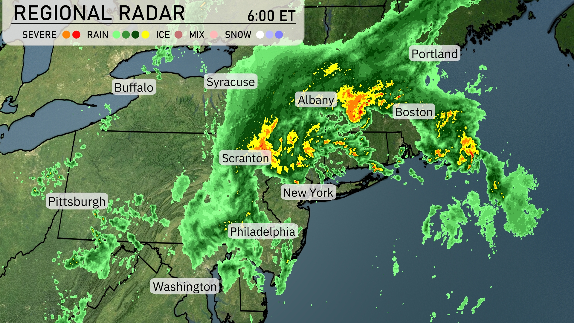
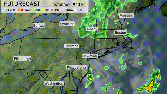
The Northeast is currently experiencing a dynamic weather pattern. Heavy rain with embedded thunderstorms is over Albany and moving toward Boston, creating a wet afternoon for much of eastern New York and southern New England. Scranton and New York City are seeing moderate rainfall, while scattered showers dot the region from Philadelphia up towards Syracuse. Areas around Portland are set to receive a drenching with a steady band of rain passing through. Buffalo and Pittsburgh are enjoying a break from precipitation with overcast skies.
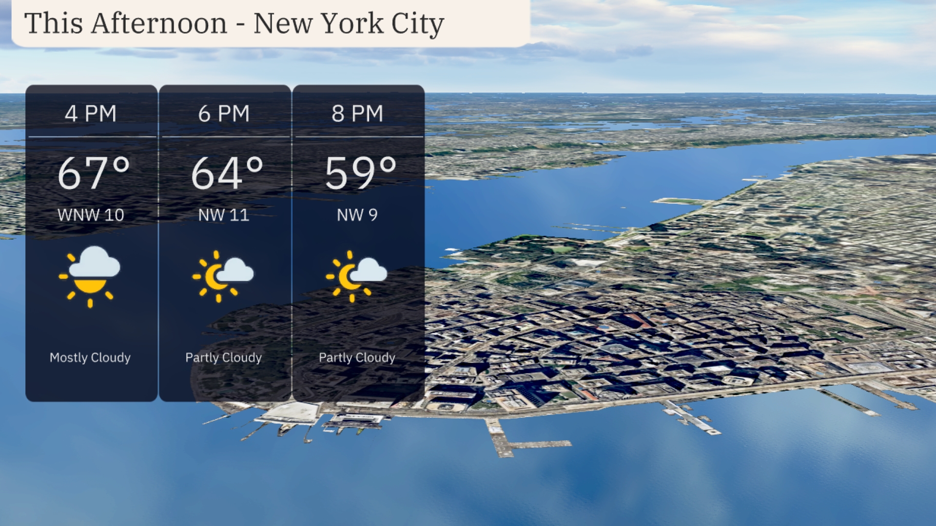
New York City this afternoon will be mostly cloudy with temperatures starting at 67 degrees at 4 PM. Winds will be from the northwest at 10 miles per hour, becoming 11 miles per hour as temperatures dip to 64 degrees by 6 PM. By 8 PM, expect partly cloudy skies with temperatures cooling further to 59 degrees and winds at 9 miles per hour from the northwest.
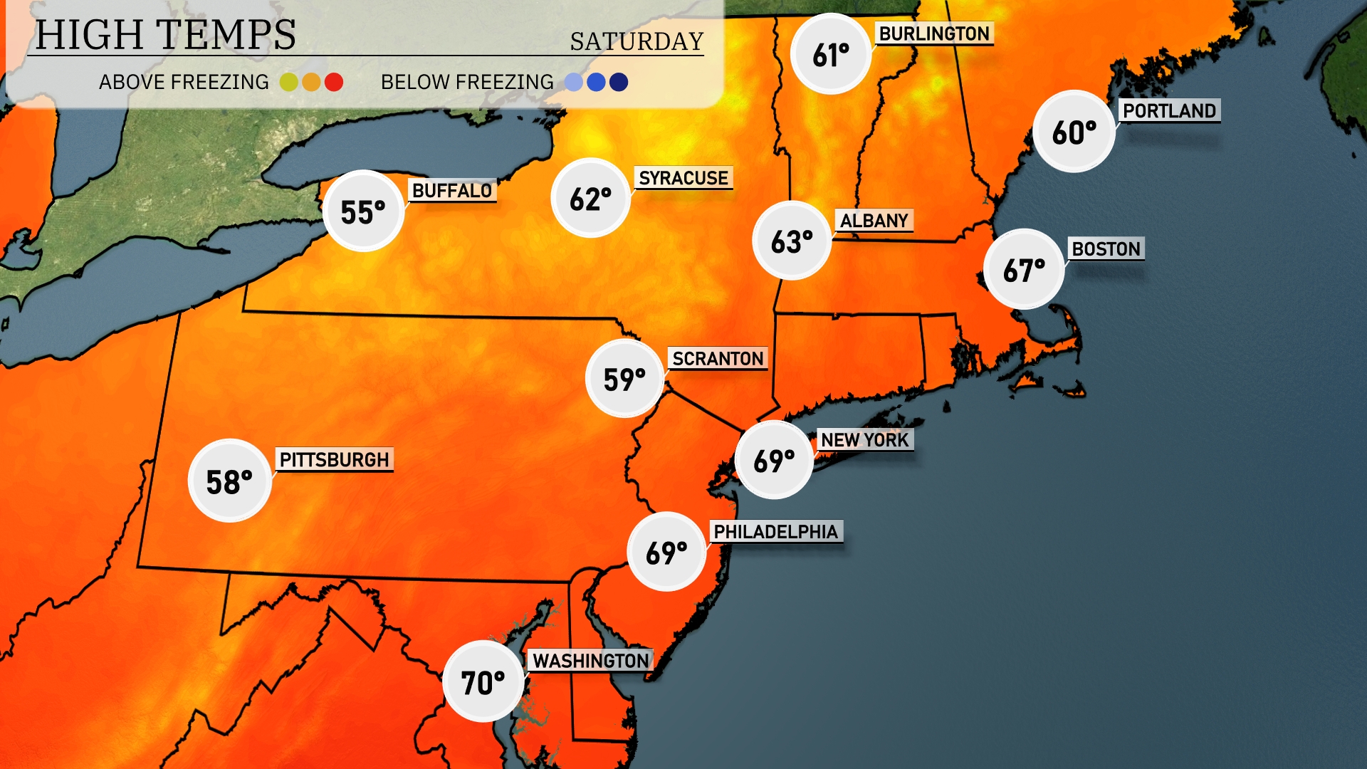
In the Northeast today, temperatures are showing a nice range as we head into June. New York City is warming up to 69 degrees, while Philadelphia is matching that with a high of 69 as well. Up north in Boston, expect a warmer afternoon, reaching 67 degrees. Scranton is on the cooler side at 59, and Pittsburgh is slightly chillier with a high of 58. Buffalo is the standout with cooler temps, only hitting 55 degrees today.
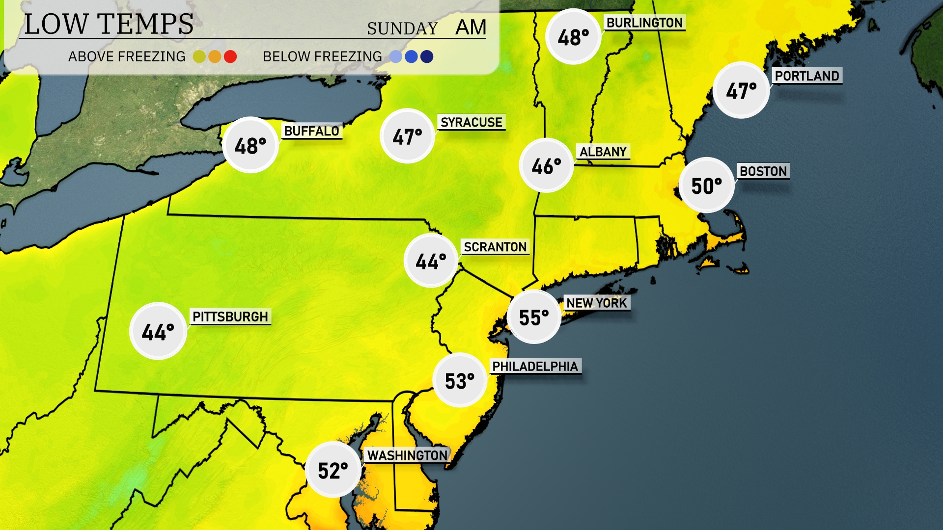
Tonight in the Northeast Pittsburgh drops to 44 degrees. Scranton will match that low. New York City is forecast to cool down to 55 degrees, while Philadelphia will stay slightly warmer at 53. Albany can expect a low of 46, and Boston will end the day at 50 degrees.
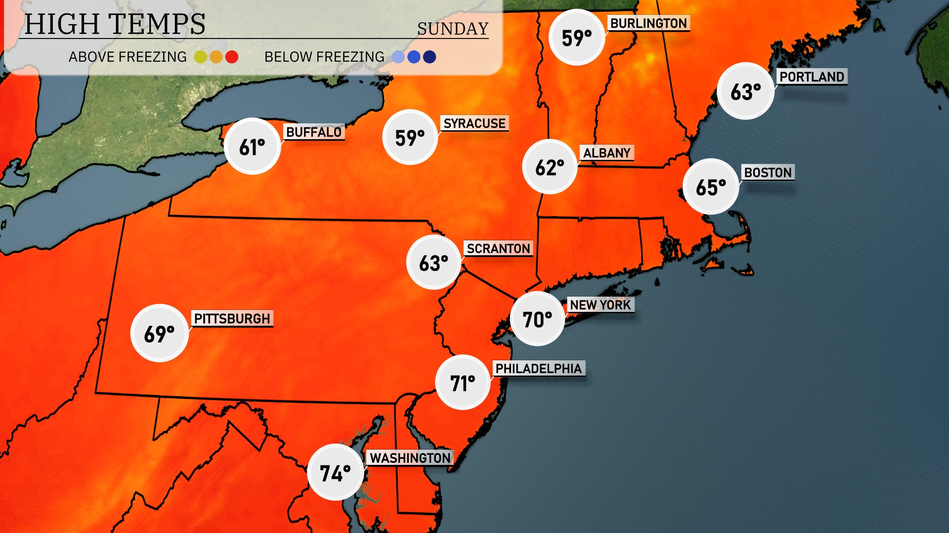
Tomorrow New York City can expect a high of 70 degrees, while Philadelphia will reach 71. In Boston, temperatures will peak around 65 degrees, and Albany is forecasted at 62. Scranton will see a cool high of 63 degrees, and Pittsburgh is set to hit 69 degrees.
A cold front is set to impact the Northeast, bringing scattered showers and potential storms, particularly from Albany to Portland throughout Saturday. Expect the heaviest rain to sweep through Boston by evening, possibly disrupting outdoor activities. New York City and surrounding areas may see isolated thunderstorms with brief heavy downpours. Temperatures will slightly dip following the frontal passage, creating cooler conditions moving into Sunday. Travelers in the region should be vigilant as rain and wind could impact driving conditions, especially in the late afternoon and evening hours.
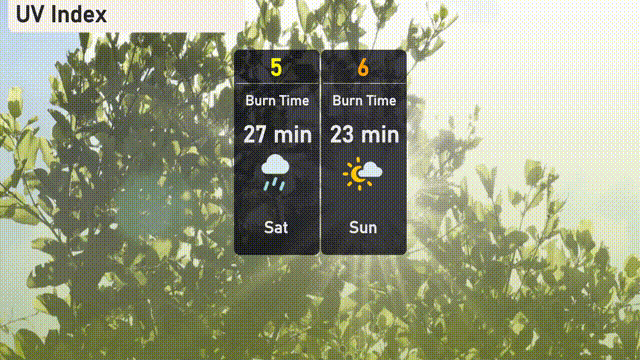
Today in New York City, the UV index is moderate at 5, with a burn time of about 27 minutes under direct sunlight. Be cautious if you’re outdoors, especially during peak sun hours. For Sunday, expect the UV index to increase to 6, reducing the burn time to approximately 23 minutes, so pack your sunscreen if you’re heading out.