NYC Weather Watch: Sunny Days and Stormy Skies Ahead
By
Amy Freeze
Explore the week's weather forecast for NYC! From sunny spells to potential showers, here's everything you need to plan your days effectively.
As New York City braces for a week of varying weather conditions, stay updated with our precise forecasts for each day. Whether it’s sunny skies or potential showers, be prepared for whatever comes your way.
This week in New York City, we’re seeing a mix of weather conditions from clear skies to approaching storms. Dive into our detailed daily forecasts so you can plan your week smoothly. With temperatures ranging from mild to warm and potential afternoon showers, it’s a week to watch closely. Don’t forget to check the UV index and pack your sunscreen for those brighter days!
Detailed Forecasts:
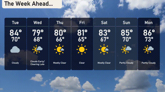
Tuesday: Cloudy skies, high of 84 °F.
Wednesday: Early clouds clearing, high of 79 °F.
Thursday: Mostly clear, high of 80 °F.
Friday: Sunny with a high of 81 °F.
Saturday: Mostly clear, high of 83 °F.
Sunday: Partly cloudy, high of 85 °F.
Monday: Partly cloudy, high of 86 °F.
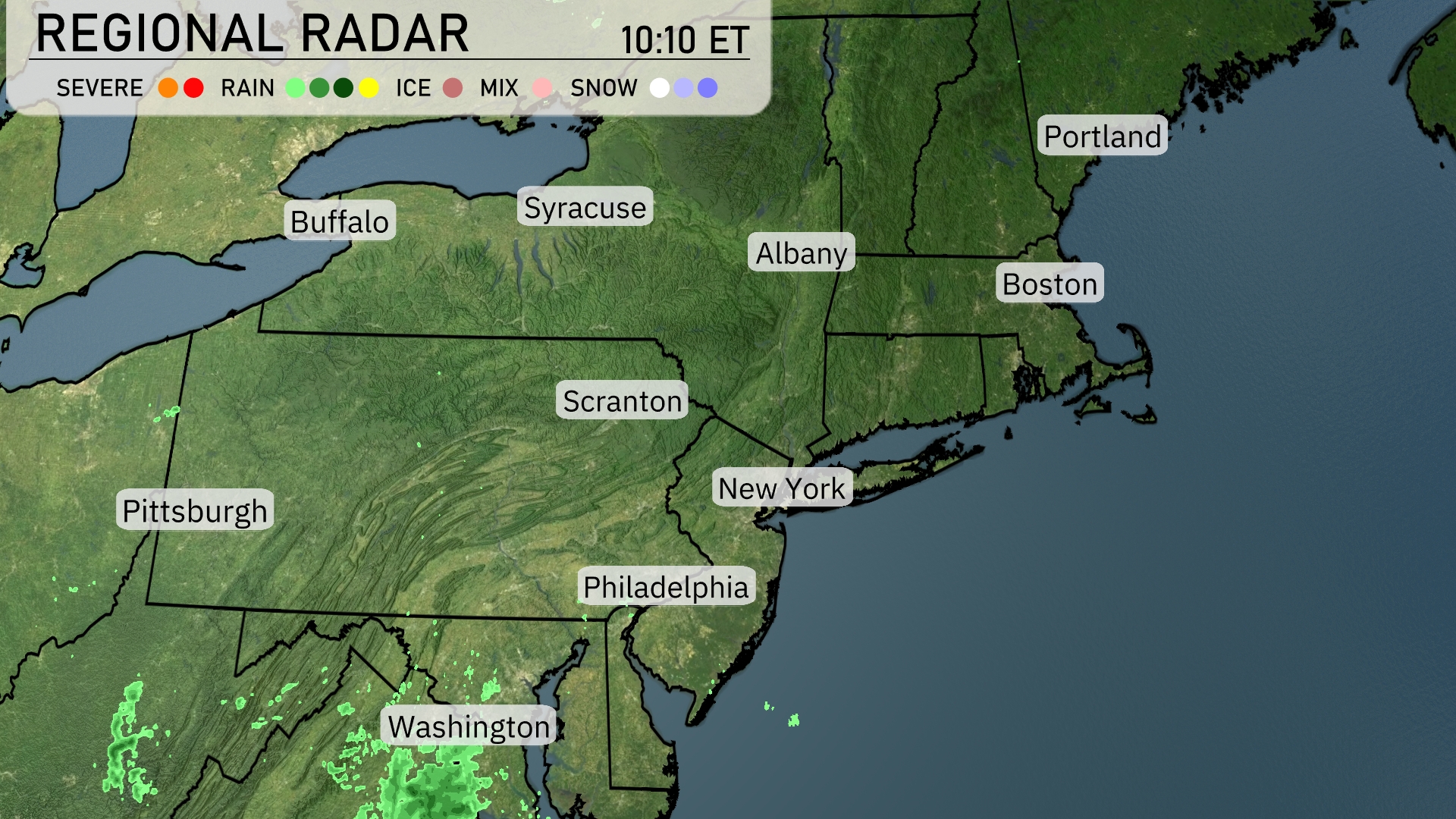
A storm system is currently bringing rain showers to the area near Washington, D.C., with precipitation moving toward the Northeast. The rest of the 95 corridor, including major cities like New York, Boston, and Buffalo, have clear conditions with no precipitation. As storms move northeastward, Syracuse and Albany should prepare for potential showers later in the day. Pittsburgh and Philadelphia remain calm under mostly clear skies.
In New York City tomorrow morning, temperatures start at 74 degrees at 8 a.m. with a light east-northeast wind at 7 mph. By 10 a.m., expect temperatures to rise to 77 degrees, maintaining the same wind conditions. Cloudy skies dominate the early hours, transitioning to mostly cloudy by noon as temperatures reach 82 degrees with an east wind at 8 mph.
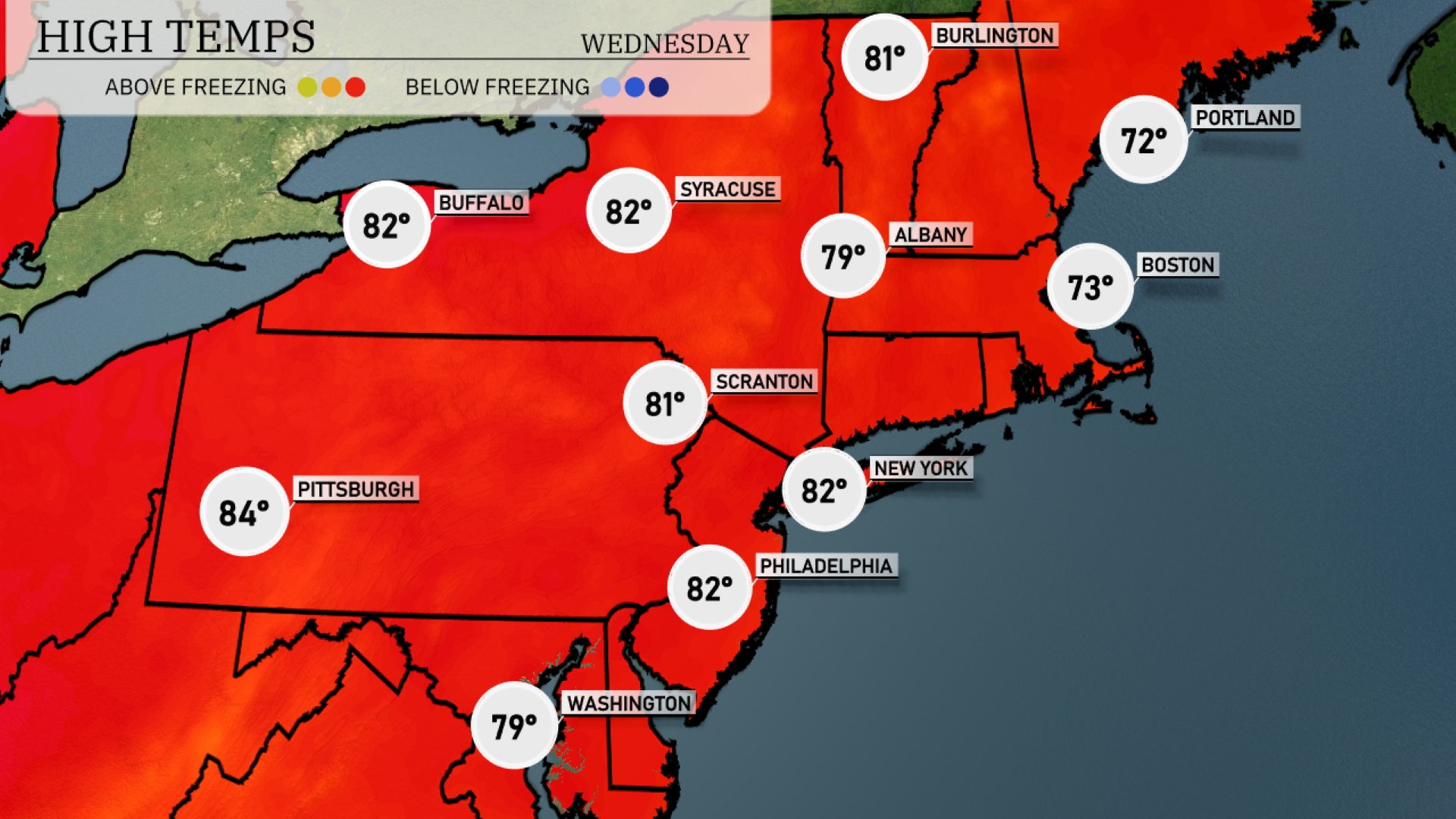
Tomorrow, Pittsburgh will experience a warm day with a high of 84 degrees, making it one of the hottest spots in the Northeast. Buffalo and Syracuse will also see highs of 82 degrees, while Scranton aligns closely at 81. New York City and Philadelphia will warm up to 82 degrees, indicating a trend of above-average temperatures across the region. Boston and Portland will be cooler, with highs of 73 and 72 degrees, respectively.
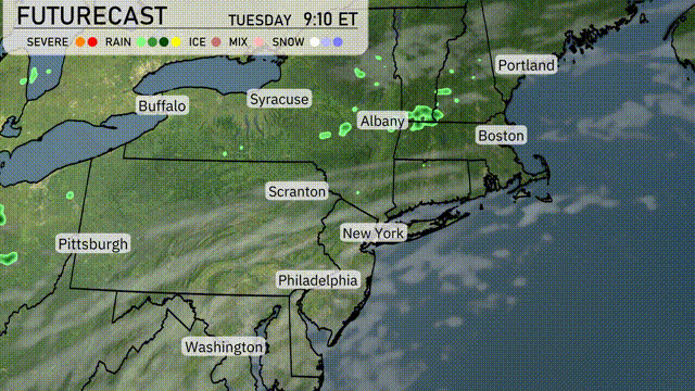
A cold front approaches the Northeast tomorrow, influencing weather across major cities like New York and Boston. Expect scattered showers and possibly isolated thunderstorms, particularly in the afternoon and evening. Temperatures will start in the mid-70s and could drop into the mid-60s by the evening as the front passes. Winds may pick up, especially along the coast, leading to potential minor disruptions.
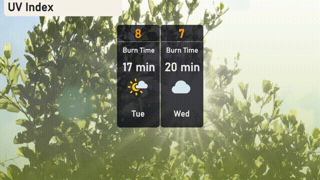
Today in NYC, expect the UV index to hit a high of 8 with a burn time of around 17 minutes, reminding everyone to shield those rays. By tomorrow, it eases slightly to a level of 7, offering a bit more time—20 minutes—before the sun’s effects are felt.
Tuesday: Cloudy skies with a high of 84 degrees and a low of 70 degrees.
Wednesday: Expect clouds early, clearing late with a high of 79 degrees and a low of 68 degrees.
Thursday: Mostly clear conditions with temperatures peaking at 80 degrees during the day and dropping to 66 degrees at night.
Friday: Clear skies and sunny, reaching a high of 81 degrees, cooling to 65 degrees overnight.
Saturday: The day will be mostly clear with a high of 83 degrees and a nighttime low of 67 degrees.
Sunday: Partly cloudy with temperatures climbing to 85 degrees, with a low of 70 degrees.
Monday: Partly cloudy again, capping the week with the warmest temperatures of a high of 86 degrees and a low of 73 degrees.