NYC Weather Whirlwind: From Sunscreen to Thunderstorms
By
Amy Freeze
This week in NYC and the Northeast brings a mix of thunderstorms, clear skies, and temperature swings that will keep you on your toes. Stay updated with our daily breakdown!
The summer heats up in NYC and the Northeast with a vibrant mix of weather conditions, from sunny skies to incoming thunderstorms. Here’s what you need to know to stay prepared.
https://www.youtube.com/watch?v=M_nMxOr5sQw
Explore our full coverage of the evolving weather conditions in New York City and across the Northeast. This guide provides you with daily weather updates, safety tips for dealing with high UV indices and thunderstorms, and insights into temperature fluctuations throughout the week. Whether you’re planning your commute or a weekend outdoors, our detailed breakdown will ensure you’re well-informed and ready for anything Mother Nature throws your way. Read more at amyfreeze.ai!
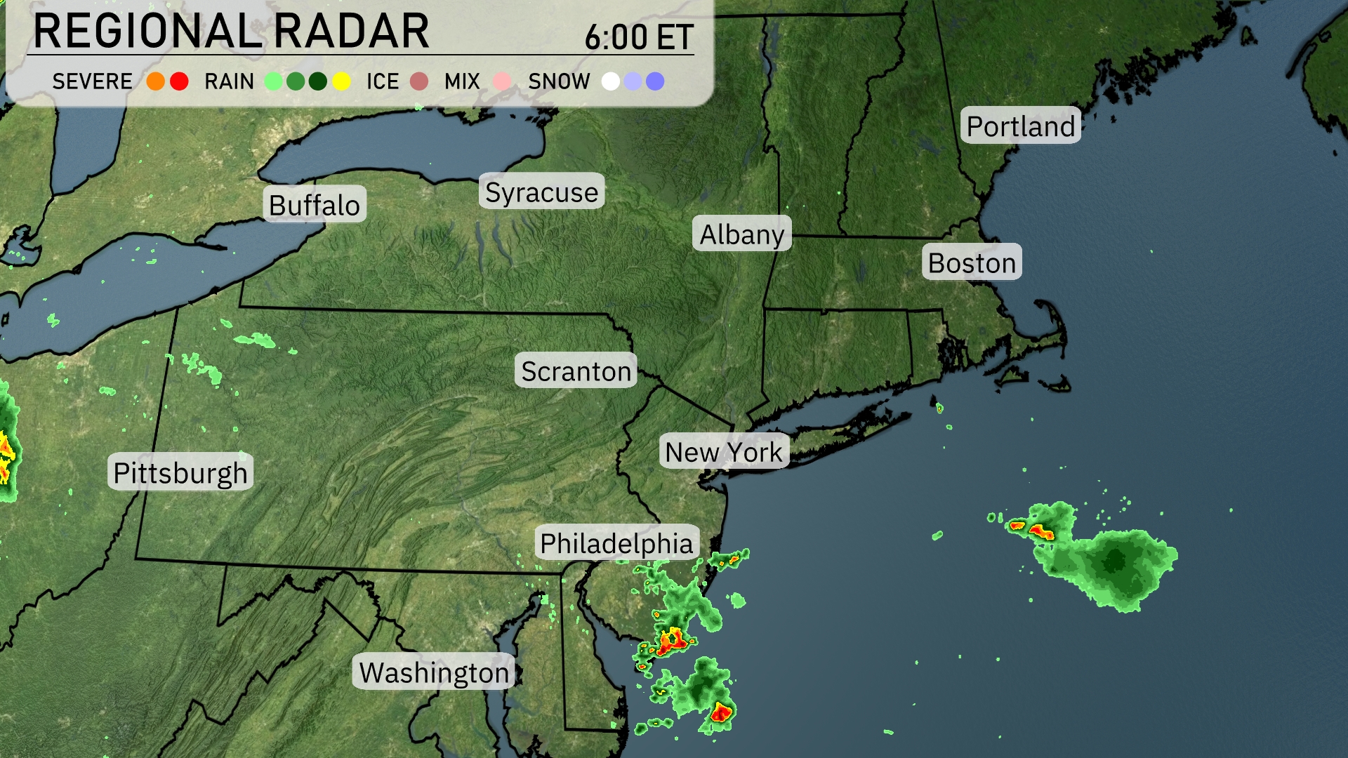
A cluster of thunderstorms is currently developing off the coast, south of New York City and Philadelphia, with rain extending into the Atlantic. Philadelphia and surrounding areas may experience showers as this system moves northeast. Scranton and Albany remain under clear conditions, while some rain showers are expected around the Washington, D.C. area. The rest of the Northeast, including Boston and Portland, is enjoying clear skies.
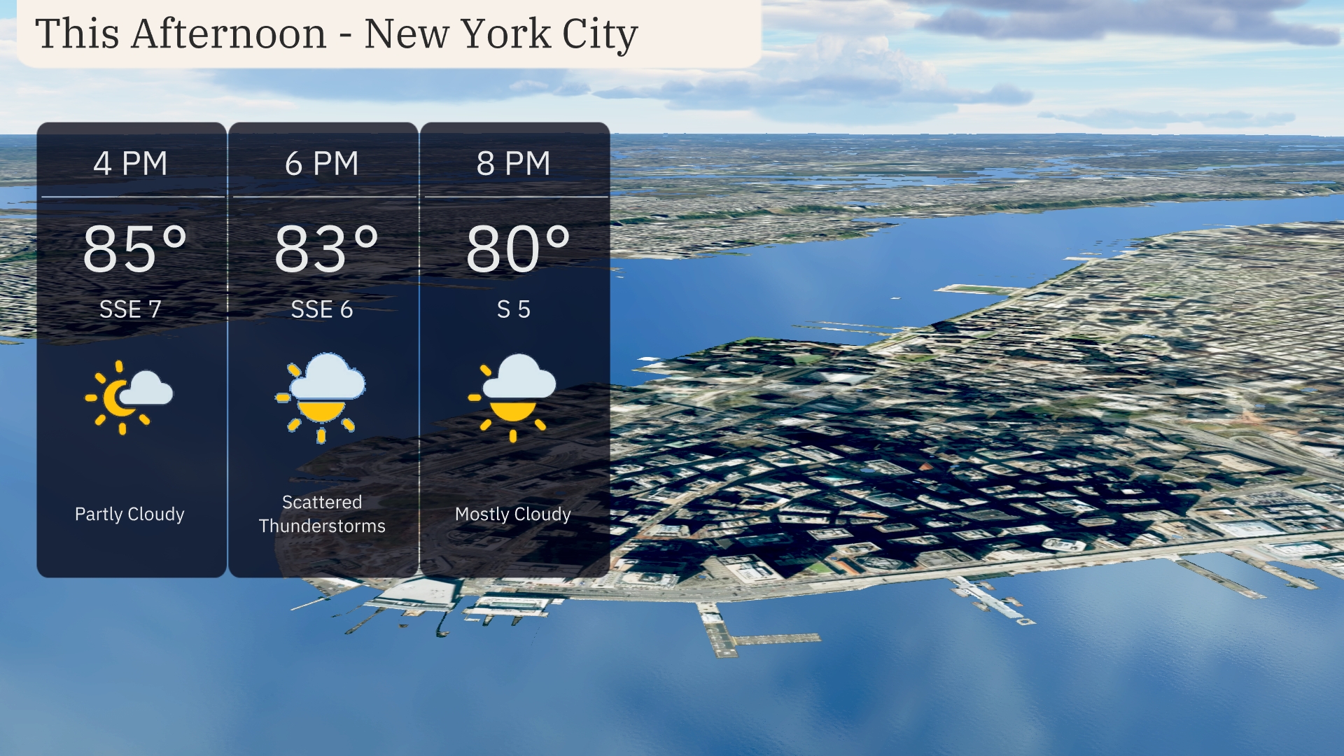
Afternoon in New York City brings partly cloudy skies with temperatures starting at 85 degrees. You can expect winds coming from the south-southeast at 7 mph. By 6 PM, be on the lookout for scattered thunderstorms and a temperature of 83 degrees, with winds decreasing slightly to 6 mph. The evening turns mostly cloudy with a steady temperature of 80 degrees and winds shifting to the south at 5 mph.
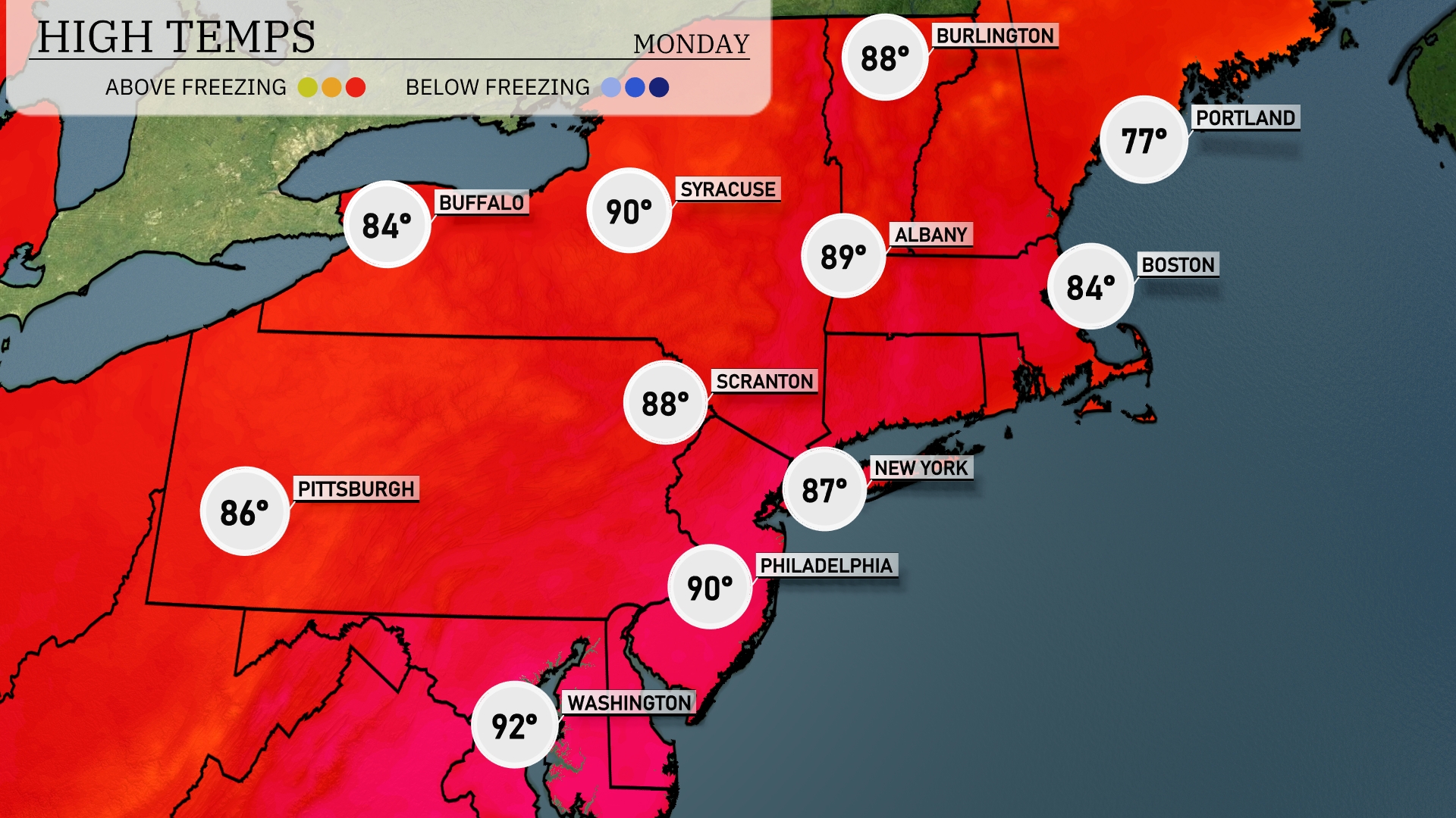
Today’s high temperatures show a notable warmth across the Northeast. New York City is hitting a high of 87 degrees, while Philadelphia is a bit warmer at 90. Scranton also sees a warm day with a high of 88 degrees. Further north, Syracuse is matching Philadelphia at 90 degrees, highlighting a significant thermal contrast with cooler readings in Boston at 84 degrees. Buffalo rounds out the highs with a comfortable 84 degrees, providing a pleasant summer day across the region.
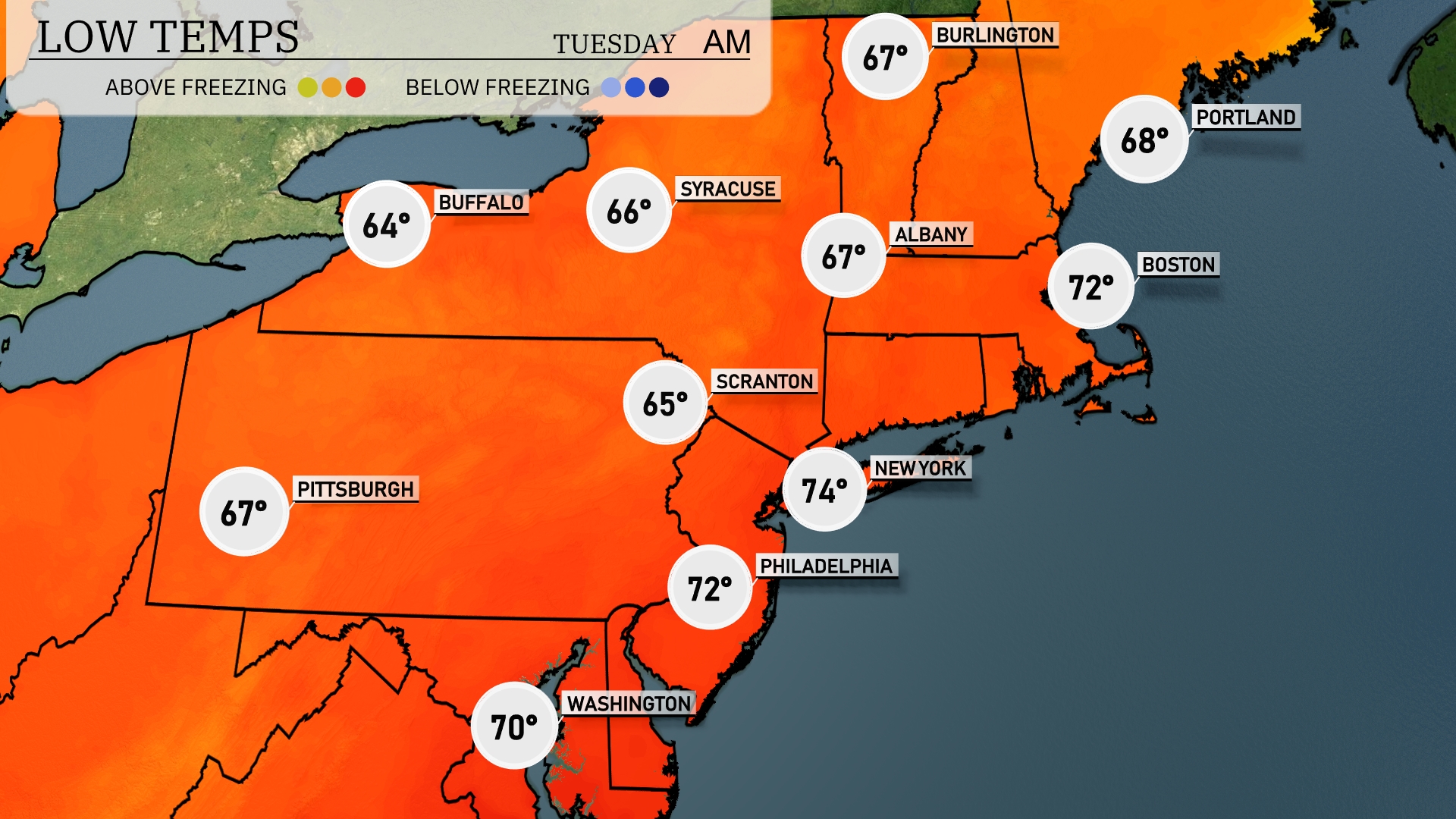
Tonight, Buffalo will cool down to 64 degrees, while Syracuse is expected to drop to 66. Scranton will see a low of 65, and Pittsburgh will settle at 67 degrees. Meanwhile, in New York City, temperatures will remain milder at 74 degrees, with Philadelphia also holding steady at 72.
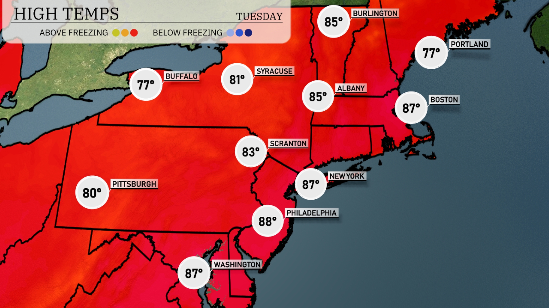
Tomorrow in the Northeast, temperatures will soar with Washington, D.C. reaching a high of 88 degrees. Philadelphia is not far behind at 87 degrees, while New York City warms up to 87 as well. Scranton is set for a comfortable 83 degrees, and Pittsburgh will hit 80 degrees.
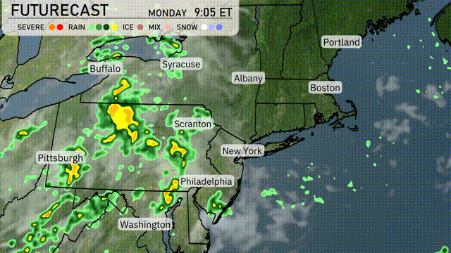
A low-pressure system brings a wave of showers and thunderstorms to the Northeast tomorrow, with the heaviest rain expected across western and central Pennsylvania. Philadelphia and New York will experience scattered showers in the morning, transitioning to heavier rain by the afternoon. Watch for gusty winds and localized flooding in areas with poor drainage. Temperatures will hover in the mid to upper 70s, slightly cooler near the coast. Beyond this, a cold front moves in, clearing the skies and bringing refreshing, cooler air towards evening into Wednesday.
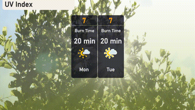
For New York City, Monday and Tuesday bring a high UV index of 7, with the potential for sunburn within just 20 minutes of exposure. It’s a great opportunity for sunscreen and hats as you enjoy outdoor activities!