Phoenix’s Weather Whirlwind: From Scorching Afternoons to Crisp Evenings
By
Amy Freeze
Dive into the dynamic weather patterns shaping Phoenix this week, from peak heat to unexpected chills, brought to you by Amy Freeze.
Catch this week’s weather highs and lows in the Southwest with Amy Freeze! From the scorching 100°F in Phoenix to cool evening breezes.
Meteorologist Amy Freeze guides you through this week’s complex weather patterns in Phoenix and surrounding Southwest areas, detailing sunny highs reaching up to 101°F and evening lows cooling down dramatically. Get tips on how to manage these dramatic shifts and what to expect weather-wise from evening to dawn. Stay informed and prepared with our comprehensive update.
In the Southwest region, the radar reveals a delightful mix of weather conditions. Starting in northern California, Redding is enjoying some light rain showers, and as we move from Reno on the periphery, some wet conditions are also visible. Meanwhile, farther south, the central California valleys, including Fresno and Bakersfield, remain dry at the moment.
In Nevada, Ely stands clear of precipitation, while nearby Cedar City is experiencing patchy clouds but no rain as of yet. Las Vegas continues to bask in clear skies, adding to the pleasant weather for those in and around the city.
California’s coastal areas, such as San Francisco and Los Angeles, appear free from precipitation, with just a few sprinkles along the coast offering a refreshing touch to the typically dry region. Moving down to San Diego, it’s clear conditions all the way, making it a perfect evening to enjoy the outdoors.
In Arizona, cities like Flagstaff are untouched by snow or rain, although chilly conditions prevail. Phoenix continues to see dry weather. Overall, a relaxing day for much of the Southwest with only scattered precipitation and mild weather conditions persisting across vast stretches.
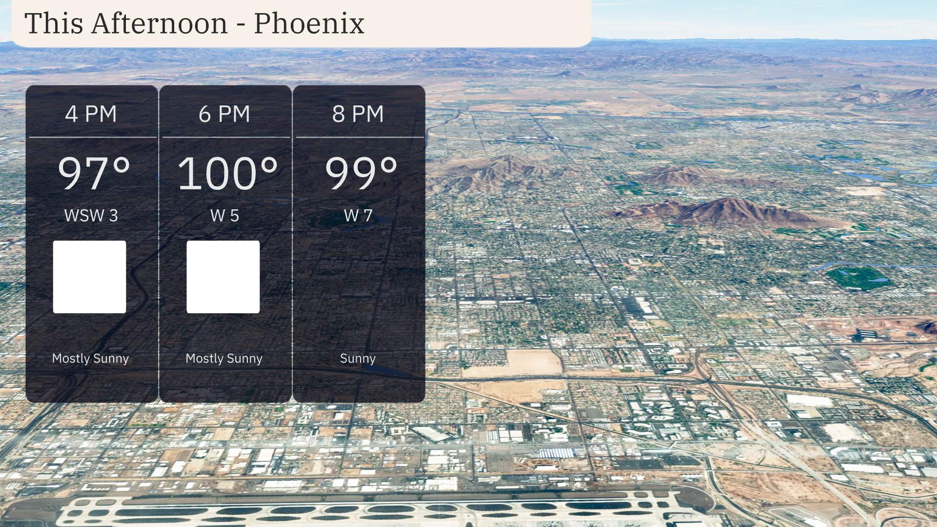
Phoenix is heating up this afternoon with temperatures climbing to 97 degrees by 4 PM, reaching a peak of 100 degrees at 6 PM. Winds are light, coming from the west-southwest at 3 miles per hour, shifting to a westerly direction at 5 miles per hour by 6 PM. Skies are mostly sunny, offering plenty of sunshine throughout the afternoon. By 8 PM, temperatures will slightly decrease to 99 degrees with winds picking up a bit more from the west at 7 miles per hour. Expect a warm and sunny afternoon perfect for outdoor activities, but stay hydrated!
Let’s take a look at today’s high temperatures across the Southwest region. In Las Vegas, it’s a sizzling 97 degrees, while Phoenix is even hotter at 100 degrees. Further north, Cedar City sees a pleasant high of 79 degrees, while Ely checks in at 77. The coastal areas are holding onto some mild temperatures, with San Diego reaching 81 degrees and Los Angeles at 79. Meanwhile, in the central valley, Fresno is a bit warmer at 84 degrees, and Bakersfield is feeling it at 86. A notable contrast today with the extreme heat in the desert versus the more mild inland locations.
Tonight in the Southwest, temperatures are expected to take a dip. Ely will see a low of 34 degrees, quite a drop from recent nights. Salt Lake City will experience a chillier 43 degrees, while Las Vegas stays warmer at 63 degrees. In Flagstaff, anticipate a low of 41, contrasting with 50 degrees in Fresno and San Francisco. Los Angeles will remain mild with a low of 50 degrees, and San Diego will be slightly warmer at 55. Overall, prepare for a noticeable shift as cold air settles in across the region.
High temperatures for tomorrow in the Southwest are shaping up to be quite warm, largely influenced by a broad high-pressure system parked over the region.
In Southern California, Los Angeles is set to reach a high of 72 degrees, while San Diego will also see similar numbers at 72 degrees. Further inland, Fresno is heating up to a notable 81 degrees, and Bakersfield will warm to 82 degrees.
As we move to Nevada, Las Vegas will be hot, hitting 91 degrees, while Ely reaches a more mild 72 degrees. Up north, Reno will see temperatures around 70 degrees.
In Arizona, Phoenix is on track to sizzle with an impressive high of 100 degrees, significantly above average for this time of year, while Flagstaff remains cooler at 73 degrees.
Overall, the region’s temperatures are trending warmer, with several areas experiencing highs well above the seasonal averages.
On the Southwest futurecast for tomorrow, a mostly sunny and dry day prevails across the desert regions, with temperatures trending upward, especially in the lower valleys of Arizona and New Mexico. However, farther west, a series of weather disturbances will impact California. Northern California should prepare for increased cloud cover with potential scattered showers near the coast by late afternoon. Meanwhile, Central and Southern California, including the Los Angeles area, could see light rain starting in the evening. While severe weather isn’t expected, roads might be slick with minor disruptions possible. The coastal areas and mountains should remain vigilant for brief periods of heavier rainfall, especially around the San Bernardino Mountains.
The UV index in Phoenix will reach 8 on both Friday and Saturday, categorizing the sun exposure as very high. Expect a burn time of approximately 17 minutes under direct sunlight. If you plan to be outdoors, don’t forget your sunscreen, hats, and sunglasses!