Salt Lake City’s Sunny Morning and the Sizzling Southwest – Weather Report 08/22/2025
By
Amy Freeze
Explore the weather nuances from sunny Salt Lake City mornings to the extreme heat in the Southwest. Stay ahead with our detailed forecast.
Catch up on the latest weather forecast for Salt Lake City and the scorching Southwest, featuring sunny forecasts and severe heat warnings.
This blog post takes you through a detailed weather forecast for Salt Lake City on August 22, 2025, and extends coverage to the extreme climate conditions affecting the Southwest. Learn about expected temperatures, UV index precautions, and regional weather phenomena like monsoonal moisture and scattered thunderstorms. Understand regional differences within the areas, from cool Flagstaff nights to scorching days in Phoenix and Las Vegas. Stay updated and prepared for any weather condition with our comprehensive guide.
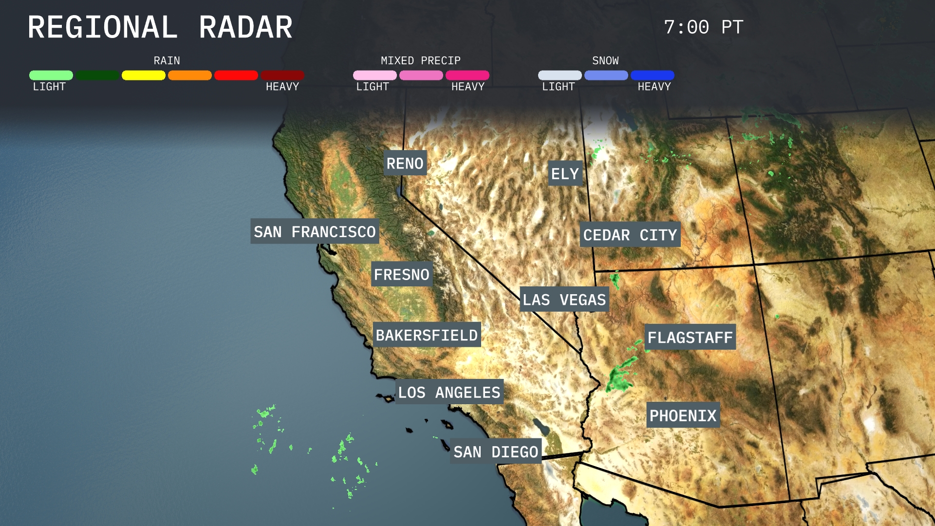
The Southwest region is seeing hot, mostly clear conditions across most areas, with a few notable exceptions. Reno and Ely are sunny and very warm this afternoon. Flagstaff and Cedar City have increasing clouds with a chance of afternoon thunderstorms. San Francisco and Los Angeles remain dry—low clouds near the Bay, sunshine building inland, and LA running hot under an Extreme Heat Warning. Further east, Phoenix is clear and dangerously hot with an Extreme Heat Warning, and Las Vegas stays hot, mostly dry, with periods of clouds.
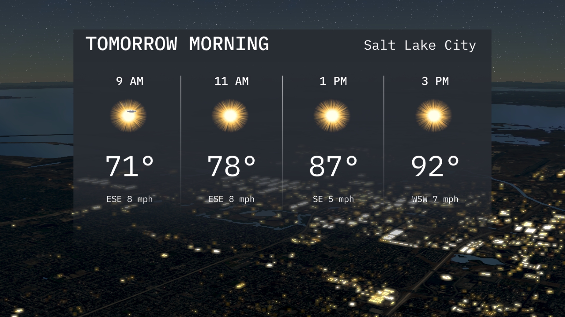
Salt Lake City tomorrow morning starts off sunny with temperatures climbing from 71 degrees at 9 AM to 78 degrees by 11 AM. Winds will be coming from the east-southeast at 8 miles per hour. It’s a clear morning perfect for any outdoor plans you may have.
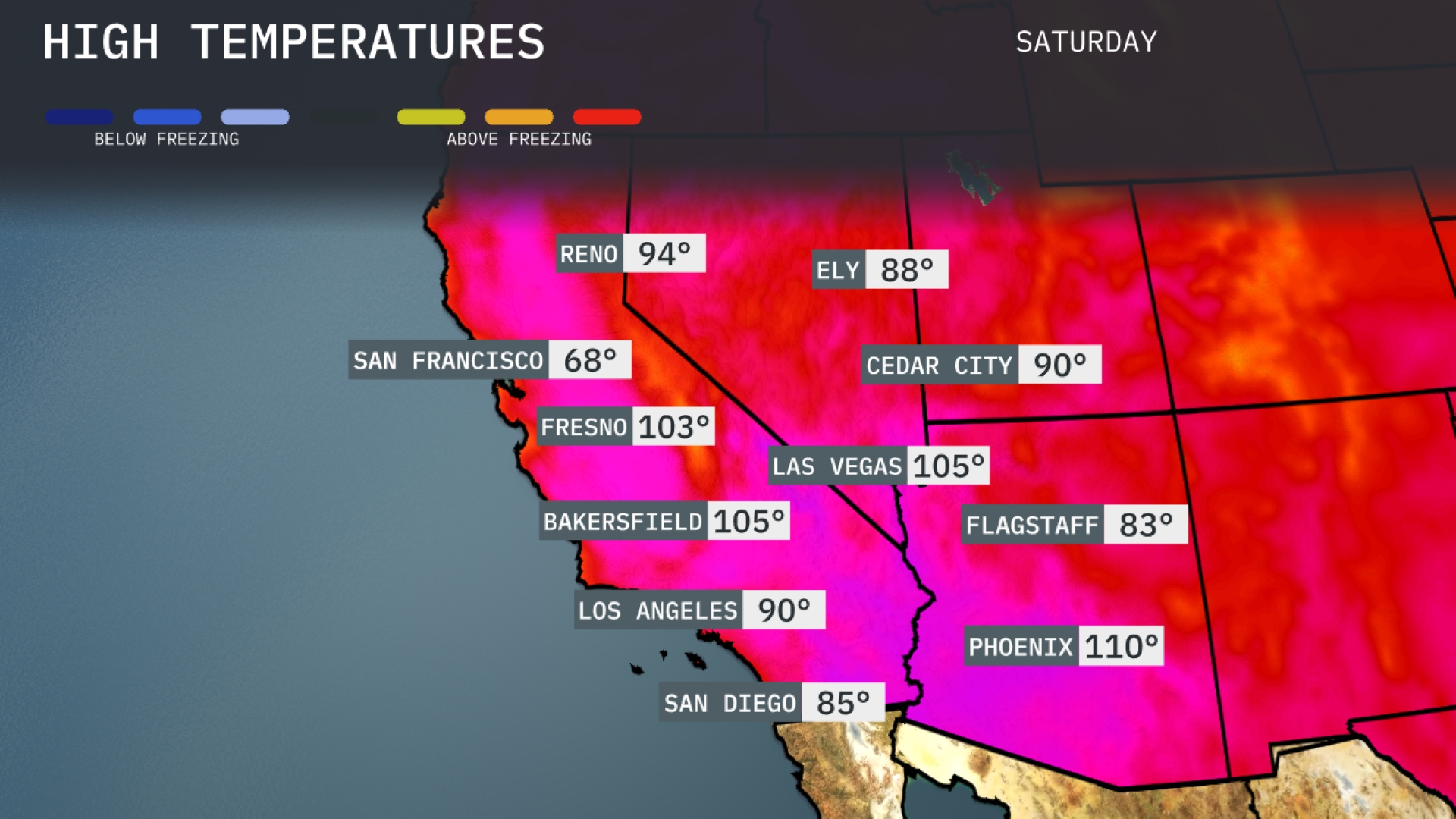
Tomorrow in Phoenix, expect scorching highs reaching 110 degrees, a notable increase above average for this time of year. Las Vegas will also sizzle, with temperatures hitting 105 degrees, maintaining a trend of consistent heat. In Bakersfield and Fresno, highs are projected to be 105 and 103 degrees, respectively, both well above seasonal norms. Los Angeles will see a warm high of 90 degrees, while San Diego remains a bit cooler at 85 degrees. Flagstaff will enjoy milder temperatures, reaching 83 degrees amid the surrounding heat.
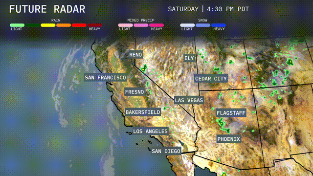
In the Southwest, expect a surge of monsoonal moisture leading to scattered thunderstorms, mainly impacting areas from Phoenix to Flagstaff. Heavy downpours could result in localized flash flooding, especially in low-lying regions and dry washes. As we move through the day, the threat of storms shifts towards Las Vegas and Cedar City, with intense lightning and gusty winds. Meanwhile, the coastal regions, including Los Angeles, will see drier and sunnier conditions, but monitor for any rapid weather changes. By Wednesday, temperatures slightly cool due to increased cloud cover, but no significant frontal passages are expected.
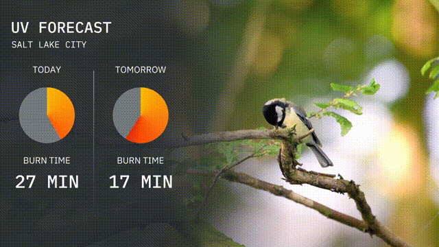
Salt Lake City’s UV index today is moderate at 4, with a burn time of about 27 minutes in direct sunlight. Tomorrow, the index rises to 7, warning of high UV exposure and a burn time around 17 minutes. Remember your sunscreen and protective gear!
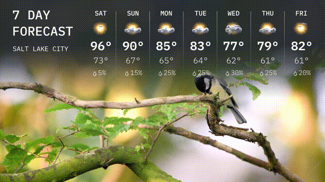
For the 7-day forecast in Salt Lake City:
Saturday: Expect sunny conditions with a high of 96 degrees and a low of 73 degrees.
Sunday: Partly cloudy with temperatures reaching a high of 90 degrees and a low of 67 degrees.
Monday: A mix of sun and clouds, with a high of 85 degrees and a low of 65 degrees.
Tuesday: Partly cloudy skies with temperatures around 83 degrees for the high and 64 degrees for the low.
Wednesday: Cloudy with a chance of rain, a high of 77 degrees and a low of 62 degrees.
Thursday: More rain showers are expected, with the temperature peaking at 79 degrees and dropping to 61 degrees at night.
Friday: Partly cloudy, with a high of 82 degrees and a cool low of 60 degrees.
Have a wonderful week ahead!