Navigating Through Clouds: Salt Lake City’s Weather Outlook
By
Amy Freeze
Explore the dynamic weather patterns over Salt Lake City with a detailed forecast for the coming week. From clear skies to incoming clouds, here's what you need to know.
Tomorrow starts with partly cloudy skies in Salt Lake City, setting the stage for a day of mixed weather across the Southwest. Get the full scoop on what to expect.
This comprehensive weather overview for Salt Lake City starts with a look at the morning’s partly cloudy skies and extends into a detailed analysis of Southwest regional weather patterns. We cover everything from scattered showers in nearby states to the sunny, clear skies over California. With daily temperatures and upcoming trends, this guide is your go-to resource for navigating the weather.
The Southwest region’s radar shows scattered rain showers moving across parts of Nevada and Northern California, notably around Reno and Ely. Light precipitation is also detected near Cedar City. Meanwhile, areas such as San Francisco and Los Angeles remain dry, with clear conditions dominating the coast. Salt Lake City enjoys clear skies, while Flagstaff sees no significant precipitation.
Tomorrow morning in Salt Lake City begins with partly cloudy skies and a temperature of 57 degrees at 8 AM. Expect a slight breeze from the east at 6 miles per hour. By 10 AM, temperatures increase to 63 degrees with clouds remaining in the mix. The wind shifts slightly to a light east-southeast flow at 5 miles per hour by late morning.
Tomorrow, Phoenix is set to sizzle with a high of 103 degrees, well above the average for this time of year. Las Vegas will also experience the heat, reaching 97 degrees, while Bakersfield and Fresno are expected to climb to 95 and 96 degrees, respectively. Across the state, Los Angeles will have a milder day at 74 degrees, providing a brief respite from the higher temperatures. This heat wave is being driven by a strong high-pressure system anchored over the region, leading to significantly above-average readings throughout the Southwest.
A dynamic pattern unfolds for the Southwest tomorrow with a mix of sun and isolated storms. Expect temperatures to climb into the low 90s in the desert regions, while coastal areas of Southern California remain cooler with highs in the mid-70s. By late afternoon, scattered thunderstorms could develop over eastern Arizona and parts of New Mexico. Northern California, especially around the Sacramento Valley, might see light precipitation with lingering showers into the evening.
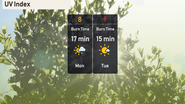
The UV index in Salt Lake City will be high on Monday, reaching 8, with a burn time of about 17 minutes in direct sunlight. For Tuesday, the UV index rises to 9, making sun exposure more intense and reducing the burn time to just 15 minutes.
For the 7-day outlook in Salt Lake City:
Monday: Cloudy with a cool high of 75 degrees and a low of 54 degrees.
Tuesday: Mostly clear skies and warming up slightly to a high of 81 degrees, the low is 56 degrees.
Wednesday: Expect a sunny day with temperatures climbing to 84 degrees and a comfortable low of 59 degrees.
Thursday: Mostly clear and warming further, reaching a high of 91 degrees and a low of 64 degrees.
Friday: Staying mostly clear with a warm high of 93 degrees and a low at 64 degrees.
Saturday: The trend continues with mostly clear skies and a high of 92 degrees, the low is 64 degrees.
Sunday: Wrapping up the week with clear skies and a high of 94 degrees, alongside a low of 64 degrees.