From Sunscreen to Sweaters: Navigating Salt Lake City’s Temperamental Weather This Week
By
Amy Freeze
Explore the diverse weather patterns from soaring temperatures to sudden showers taking over Salt Lake City and the Southwest. Gear up for the week with our complete guide!
This week in Salt Lake City, expect a mix of sunny skies and unexpected showers. Temperatures will fluctuate, reaching highs of 98°F. Stay updated with our comprehensive weather forecast.
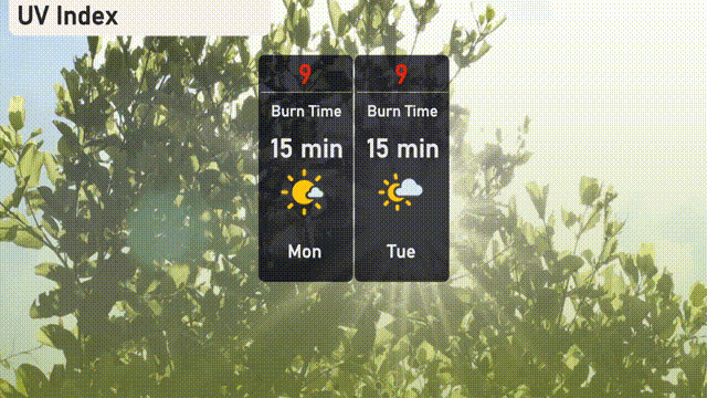
This comprehensive guide covers the weather forecasts for Salt Lake City and the broader Southwest region from June 30, 2025. From intense sun with a UV index of 9 demanding sunscreen and hats, to balmy evenings perfect for outdoor dining, every weather detail is provided to ensure your week is both safe and enjoyable. Highlights include unexpected rain showers and temperatures varying from the mid-60s to high 90s. Plan your week with our day-to-day weather breakdown and expert tips on how to dress and prepare.
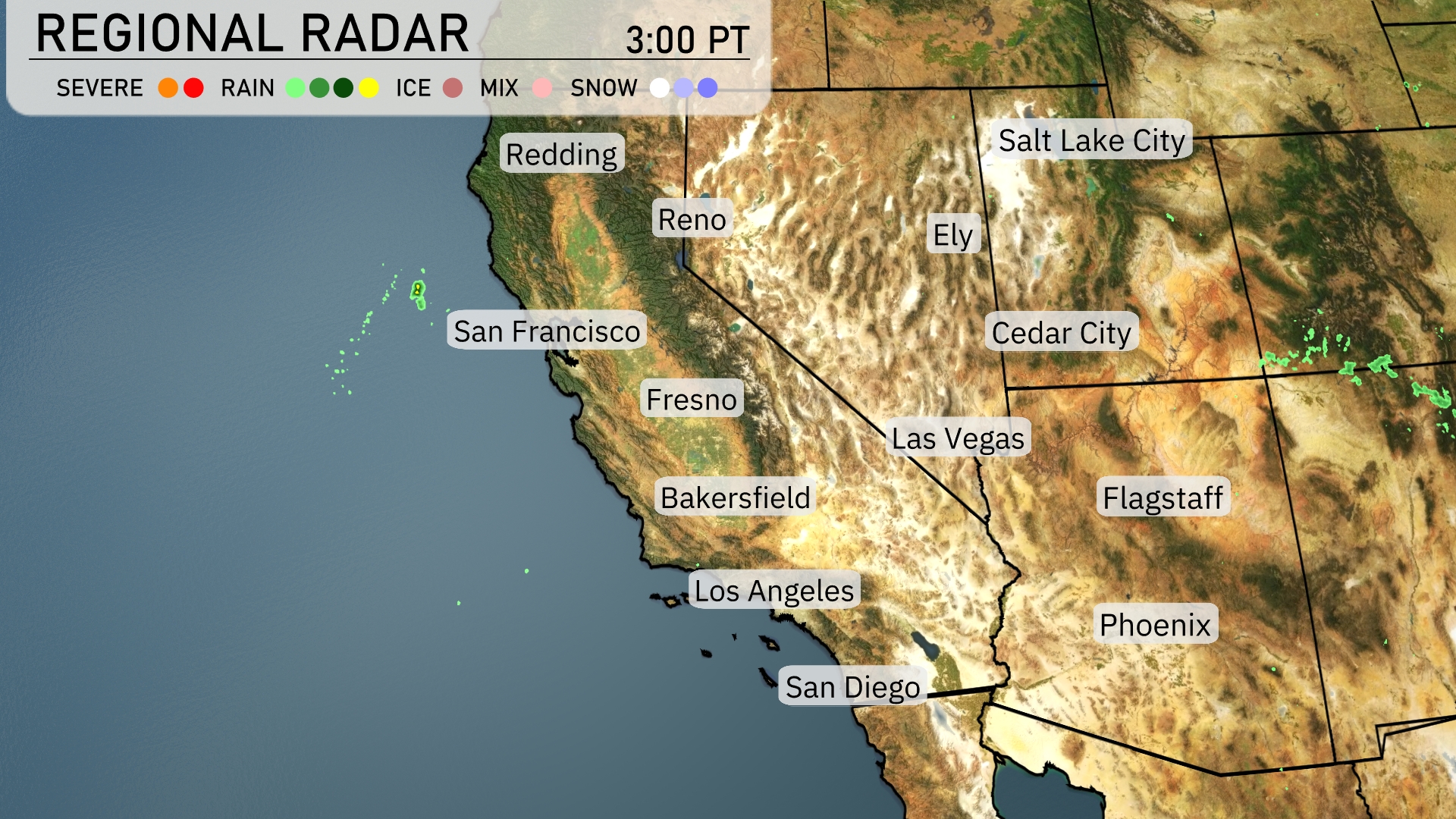
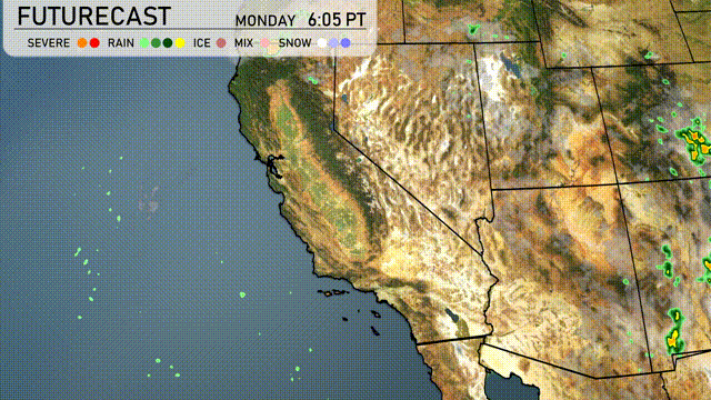
In the Southwest region, the radar shows strong storm cells moving over Central Arizona, with Flagstaff seeing some light rain activity. Clear skies dominate Southern California, including Los Angeles and San Diego, providing a pleasant day. Northern areas like Reno and Ely are seeing dry and clear conditions with no precipitation observed. Phoenix continues with dry weather, but the humidity may feel a bit high due to nearby rainfall.
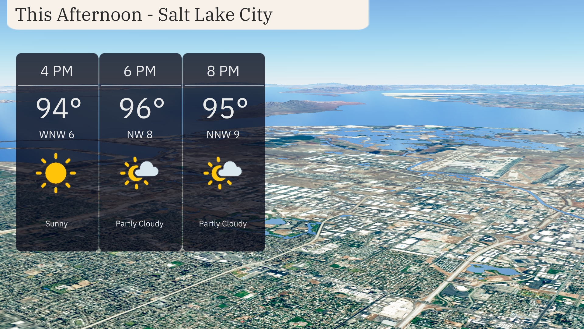
In Salt Lake City this afternoon, temperatures will be climbing to 96 degrees by 6 PM with a mix of sun and clouds. Expect a breeze from the west-northwest at 8 miles per hour. By 8 PM, the temperature will slightly decrease to 95 degrees with partly cloudy skies.
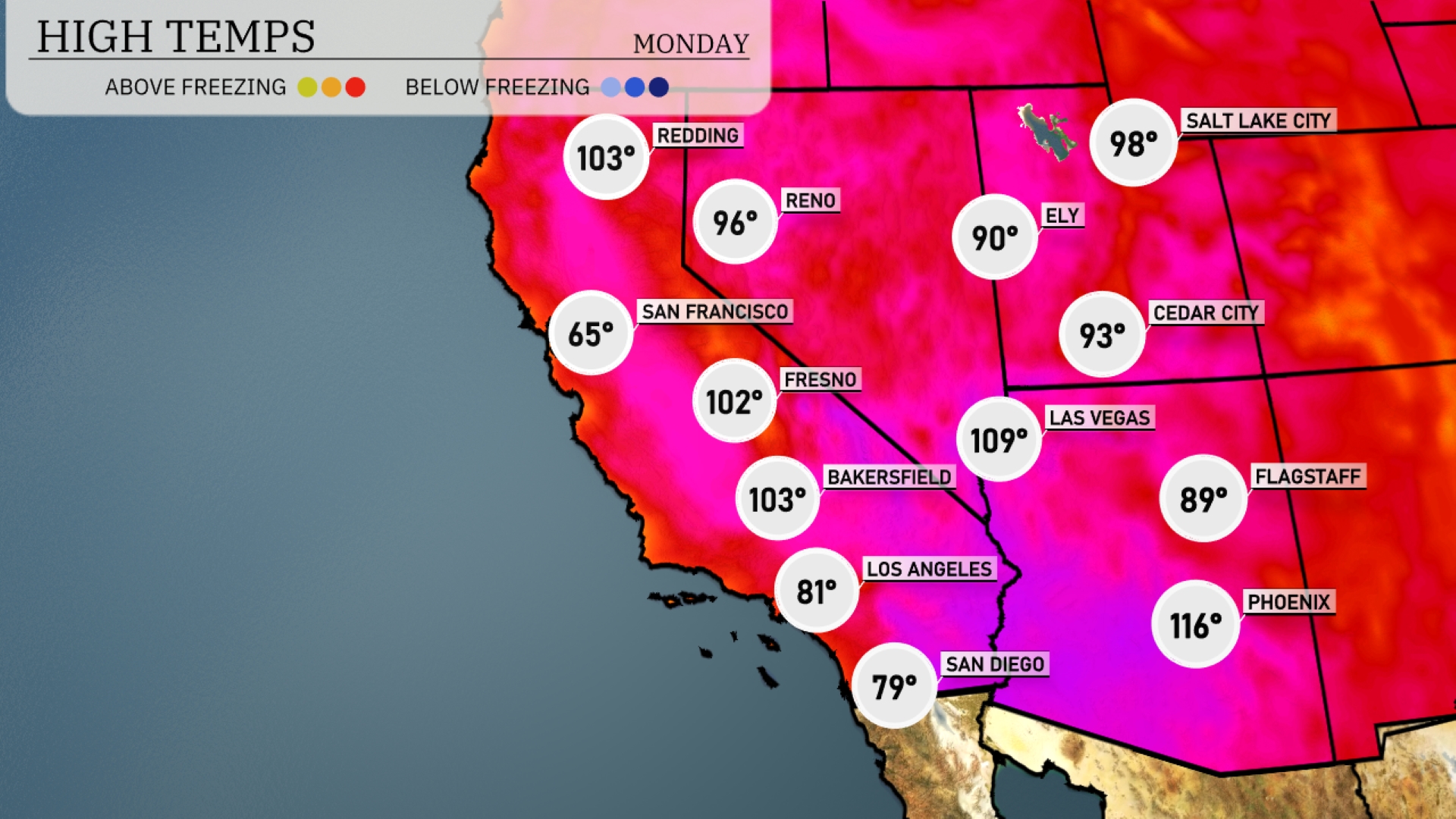
In the Southwest, temperatures are soaring today. Phoenix is leading the way with a sizzling high of 116 degrees, while Las Vegas is experiencing a warm 109. Flagstaff is cooler at 89 degrees, providing a refreshing contrast to the valley heat. Over in Los Angeles, the temperature is a more comfortable 81, but Bakersfield is rising to a hot 103. San Francisco remains the coolest in the region with a high of 65 degrees, highlighting the dramatic temperature variations across the area.
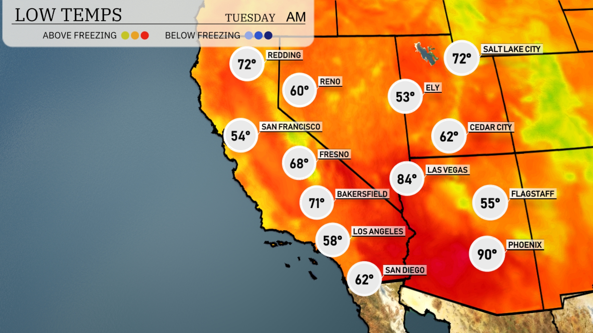
Tonight in the Southwest, temperatures will dip considerably in several key cities. Las Vegas is forecasted to fall to 84 degrees, while Phoenix will remain warm at 90 degrees. Flagstaff will see cooler conditions with a low of 55 degrees, and Los Angeles will drop to 58 degrees. San Francisco can expect a refreshing low of 54 degrees.
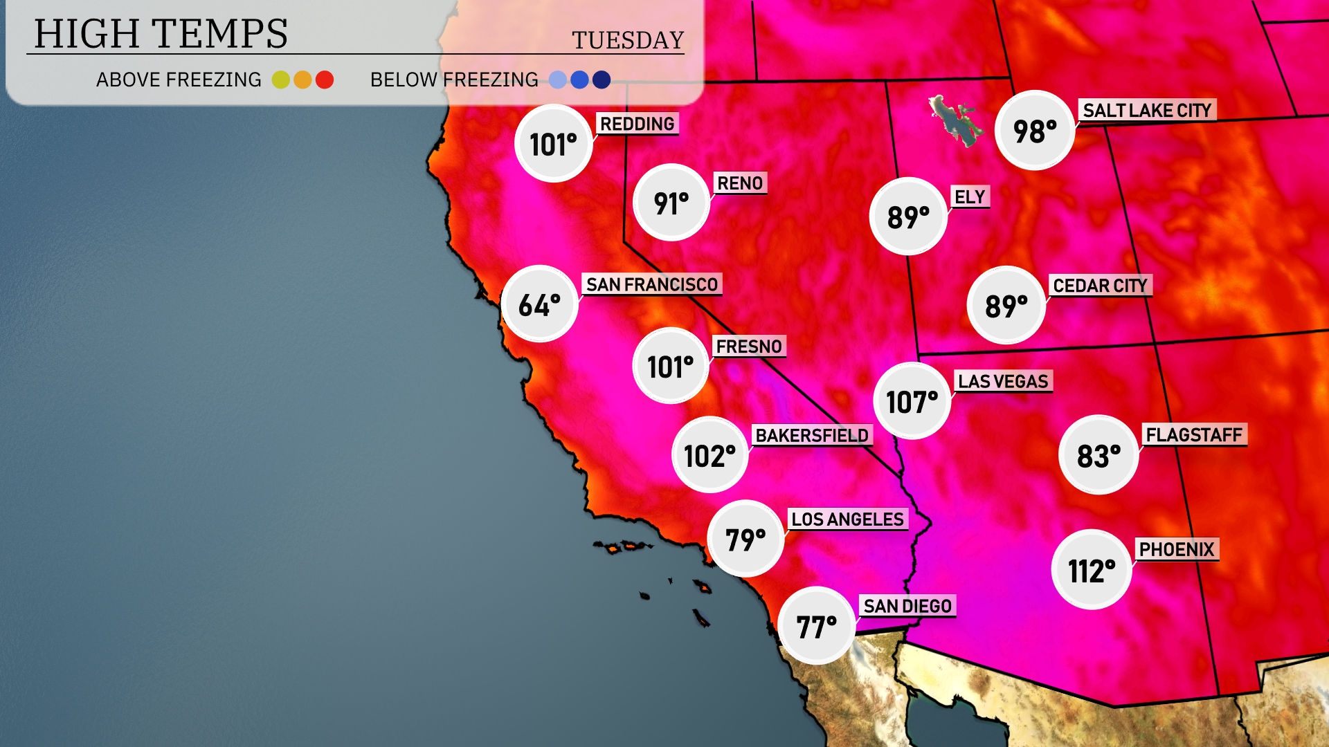
Tomorrow in Phoenix, expect scorching highs of 112 degrees, significantly above average for this time of year. Las Vegas will reach a sizzling 107 degrees, while in Bakersfield, temperatures will soar to 102 degrees. Fresno isn’t far behind, with highs anticipated at 101 degrees. Meanwhile, Los Angeles will enjoy a milder 79 degrees as a coastal breeze cools the region, creating a stark contrast to the extreme heat further inland.
A shift in weather patterns is anticipated for the Southwest tomorrow. Expect rain and isolated thunderstorms to move into Southern California as a weak front approaches, bringing the potential for tricky driving conditions, particularly over mountain areas. Northern parts of Arizona and New Mexico might experience showers, enhancing the risk of heavy rainfall in some localized regions. Temperatures are set to remain steady with highs reaching the upper 80s to low 90s in desert areas, while coastal regions see cooler conditions. Keep an eye on the forecast as flood advisories may be issued with persistent rainfall over the next 24 to 48 hours.
The UV index in Salt Lake City will be very high at 9 on Monday, with a burn time of just 15 minutes in direct sunlight. Tuesday maintains the same intensity with a UV index of 9, so be sure to take precautions like sunscreen and protective gear to enjoy outdoor activities safely!