From Sunshine to Snowfall: Navigating Salt Lake City’s Varied Weather Patterns
By
Amy Freeze
Explore a comprehensive update on Salt Lake City’s weather, from serene sunny afternoons to unexpected snowy evenings and everything in between.
Dive into today’s weather forecast with Amy Freeze! Expect clear skies in Salt Lake City, storms in Ely, and a warming trend across the Southwest.
Join Amy Freeze as she covers the dynamic weather patterns affecting Salt Lake City and the broader Southwest region, from sunny afternoons to chilly nights and stormy conditions. Get insights on how to prepare for sudden weather changes and plan your day with accuracy and ease.
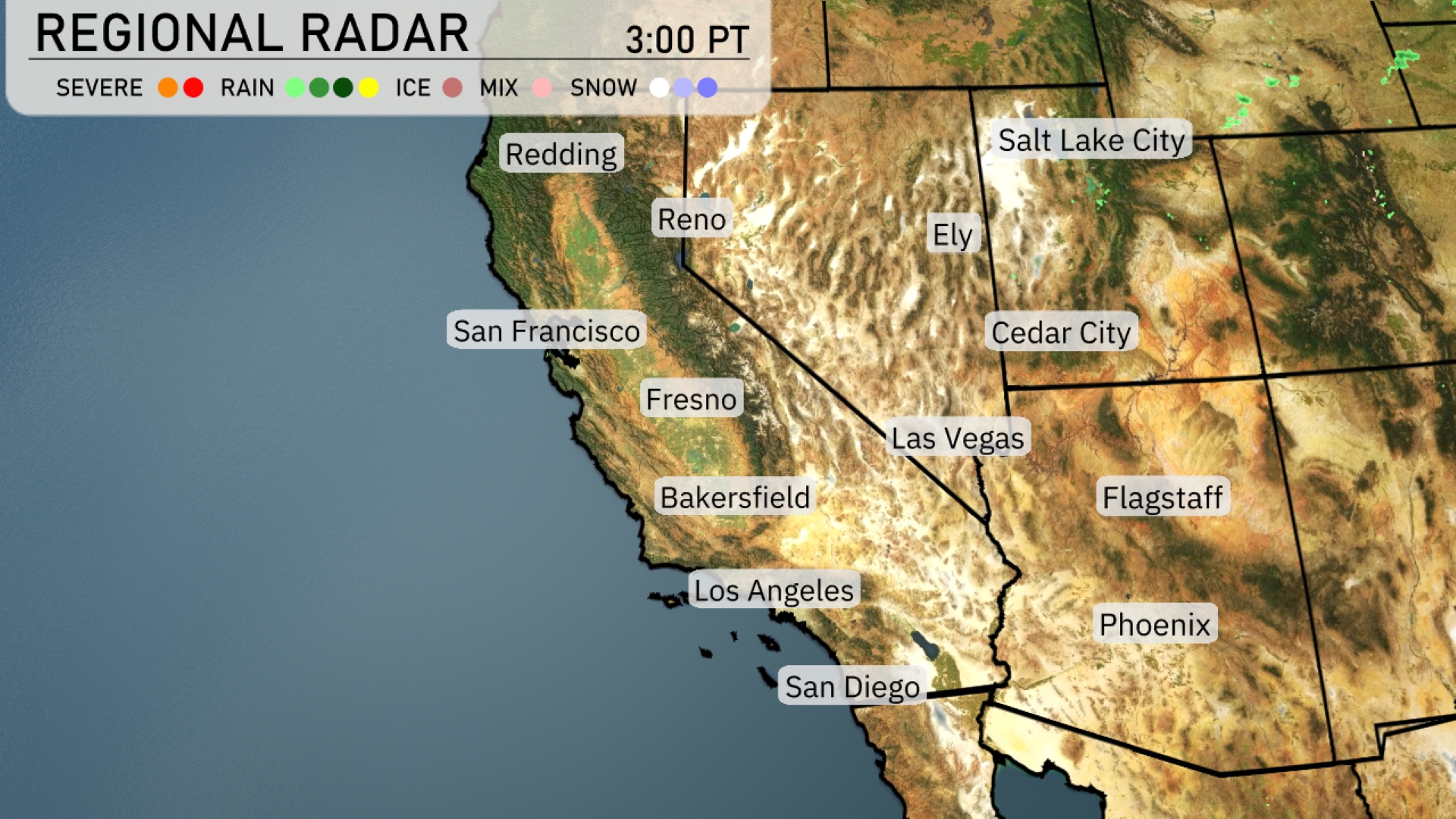
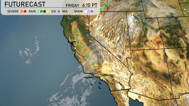
A storm system is creating a mix of rain and snow in the higher elevations around Ely, with icy conditions expected. The Sierra Nevada mountains near Reno and Cedar City are experiencing snow, which is affecting travel due to accumulations. Rain is spreading across Fresno and extending towards areas like Bakersfield, providing much-needed moisture to the region. In Salt Lake City and Phoenix, the skies remain clear, offering a reprieve from precipitation. Flagstaff can expect some clouds, but conditions are largely dry.
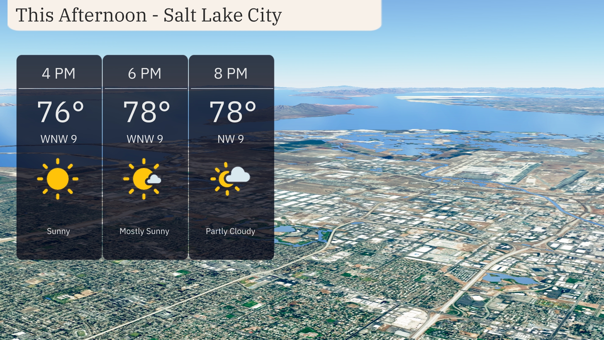
This afternoon in Salt Lake City, temperatures rise to 76 degrees by 4 PM, climbing to 78 degrees by 6 PM and holding steady through 8 PM. Winds from the west-northwest at 9 miles per hour are expected throughout the afternoon. Skies will be mostly sunny at 4 PM, with some clouds developing later, becoming partly cloudy by 8 PM.
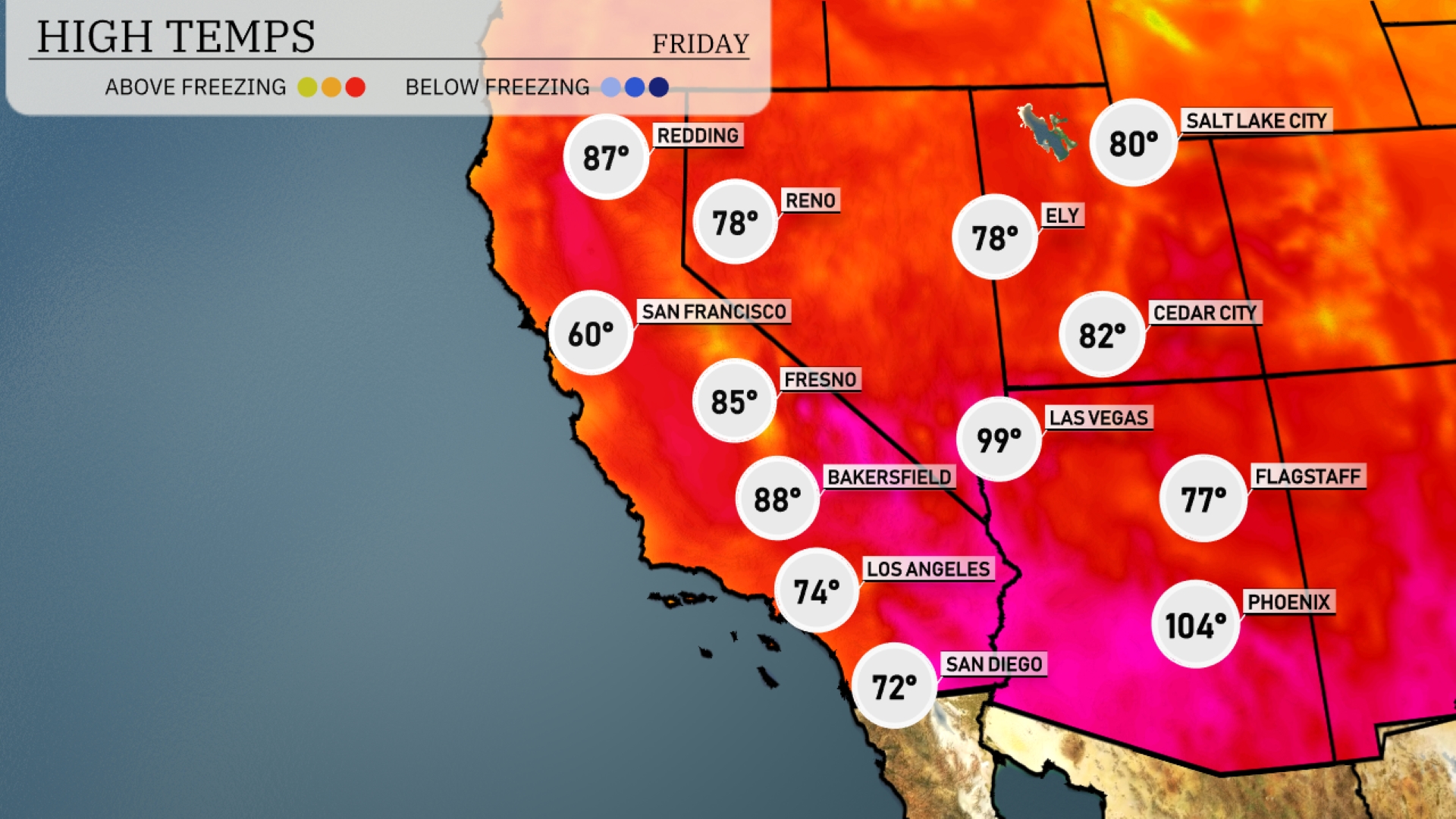
Today in Phoenix, prepare for a scorching day with a high of 104 degrees. Las Vegas is hot but slightly cooler at 99, while Cedar City enjoys a more moderate high of 82. Farther north, Flagstaff sees a pleasant 77 degrees. Down in Los Angeles, temperatures are more comfortable at 74, contrasting sharply with the heat inland in Bakersfield, reaching 88 degrees. The coastal areas offer refreshing relief, especially in San Diego, where temperatures will peak at 72.
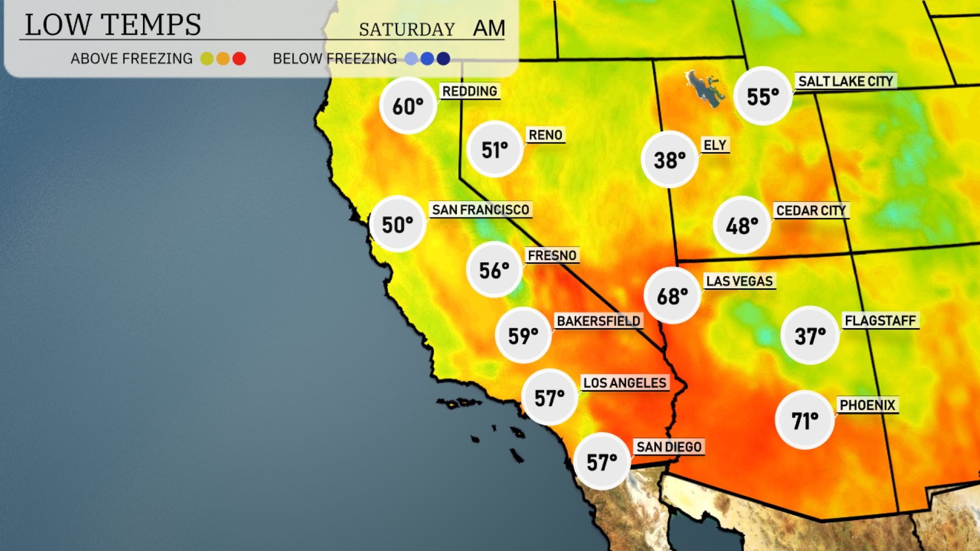
Tonight, lows in the Southwest will be notably cooler as a chill sets in. Flagstaff will dip to 37 degrees, while Ely is expecting a brisk 38. Las Vegas will feel the drop with a low of 48, and Cedar City will see a chilly 48 as well. In contrast, larger cities like Los Angeles and San Diego will remain milder, with lows of 57 and 57 respectively. Expect San Francisco to settle at a cool 50 degrees overnight.
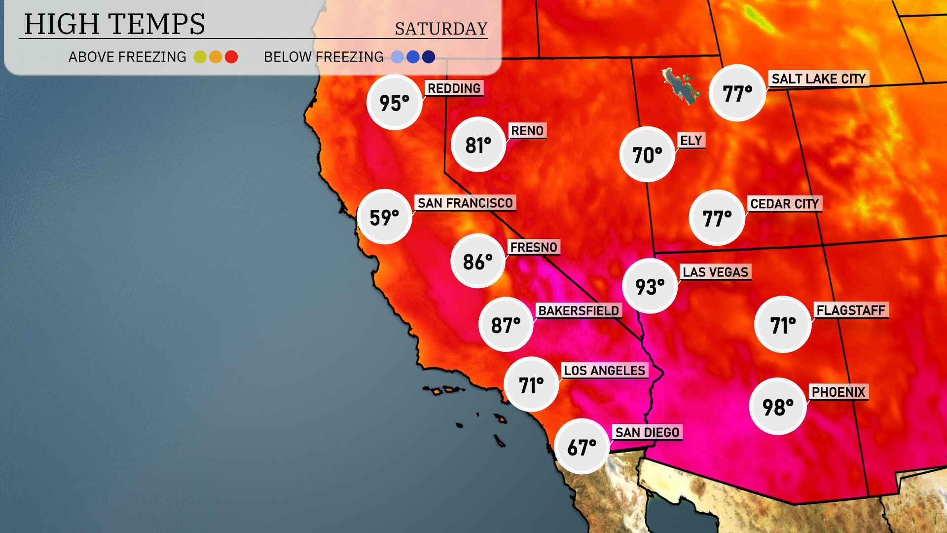
Tomorrow it’s cooler. Phoenix is expected to reach 98 degrees, while Las Vegas will hit 93 degrees. Southern California cities are also warming up, with Los Angeles at 71 degrees and Bakersfield soaring to 87 degrees. Further north, Fresno will see a high of 86 degrees, while San Francisco remains cooler at 59 degrees.
A storm system is impacting the Southwest with multiple fronts moving through the region over the next 24 to 48 hours. Expect heavy rainfall and potentially severe thunderstorms in parts of Arizona and New Mexico. The rainfall may lead to localized flooding, especially in low-lying areas and canyons. Winds are picking up across Southern California, contributing to difficult travel conditions, particularly over mountain passes. By late tomorrow, cooler temperatures will spread across the region, providing some relief from the recent heat.
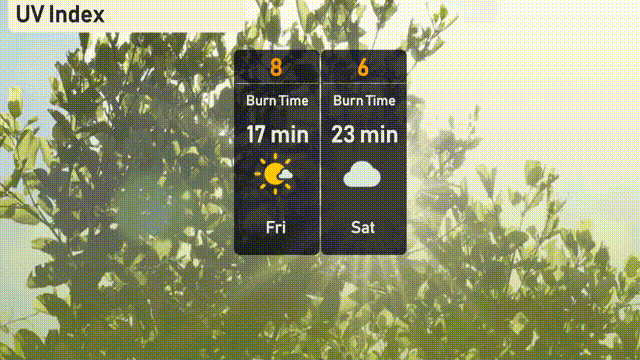
The UV index in Salt Lake City will be high today, reaching a level of 8 with an expected burn time of approximately 17 minutes. Tomorrow, the index decreases to a moderate level of 6, bringing a burn time of 23 minutes under partly cloudy skies.