Your Weekly Weather Companion in Salt Lake City – Insights from Amy Freeze
By
Amy Freeze
Dive into a comprehensive weather forecast for Salt Lake City with Meteorologist Amy Freeze. From a chilly start to sunny afternoons, know what to expect before stepping out.
This week in Salt Lake City, expect varying temperatures from chilly mornings to warm afternoons. Meteorologist Amy Freeze outlines what to expect each day with trusted forecasts and helpful tips.
Hello Salt Lake City residents and visitors! As your go-to weather source, I’ll take you through a detailed week-long forecast. From the brisk early hours, reaching up to comfy warm afternoons, we’ll cover it all. Plus, remember to prepare for fluctuating conditions like rain and snow moving through the Southwest. Don’t miss out on our daily tips to tackle the weather confidently!
The Southwest is seeing a mix of wintry weather and rain today. A small area of snowfall is impacting the Sierra Nevada, while Northern Utah, including areas around Salt Lake City, reports light snow. Rain showers are stretching from Flagstaff, moving southwest towards Phoenix. Las Vegas maintains dry conditions under partly cloudy skies. Southern California is clear, with no precipitation expected.
Expect a chilly start in Salt Lake City tomorrow morning with clear skies and temperatures beginning at 34 degrees. By 10 a.m., temperatures will rise slightly to 36 degrees under sunny conditions. Winds will be light, shifting from east at 7 mph to 6 mph. As noon approaches, temperatures will climb to 43 degrees with continued sunshine and a northeast wind at 5 mph.
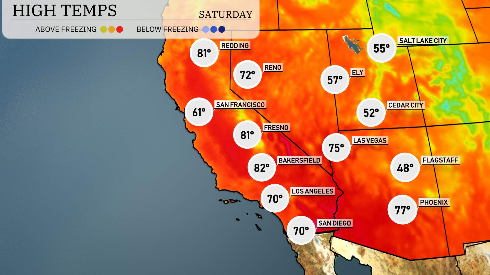
Bakersfield is set to reach a high of 82 degrees, while Fresno warms up to 81. Los Angeles will enjoy a pleasant 70 degrees, and San Diego will match that with a high of 70 as well. Meanwhile, Las Vegas can expect temperatures around 75 degrees, and Phoenix will peak at 77. These warm readings are influenced by a strong ridge of high pressure dominating the region, providing clear skies and ample sunshine.
A cold front will make its way through the Southwest, bringing a mix of rain and snow, particularly evident from northern Arizona to southwest Colorado. Expect increased precipitation, easing into more scattered showers as it progresses into New Mexico by Friday night. Gusty winds are likely across the higher terrain, possibly leading to challenging travel conditions, especially over mountain passes. As this system departs, anticipate a cool down, with temperatures dropping by up to 15 degrees, followed by clear skies and drying conditions moving into the weekend.
Salt Lake City will see a UV index of 6 on Friday, with potential sun exposure risks leading to a burn time of about 23 minutes. Saturday’s index rises to a high of 7, bringing a quicker burn time of 20 minutes, so remember to apply sunscreen and seek shade during peak solar hours.
For the 7 Day Outlook in Salt Lake City:
Friday: Mostly clear with a high of 55 degrees and a low of 43.
Saturday: Look for mostly cloudy skies with temperatures rising to 65 degrees and a low of 47.
Sunday: Partly cloudy, reaching up to 65 degrees with a low of 44.
Monday: Clear and sunny to kick off the week, with a high of 70 degrees and a low of 48.
Tuesday: Partly sunny conditions, highs will be around 71 degrees, lows dropping to 50.
Wednesday: Enjoy partly cloudy skies with temperatures peaking at 68 degrees and a low of 48.
Thursday: Partly cloudy, with the temperature rising to 72 degrees and a low of 51.
Enjoy the week ahead, and stay weather aware!