Storm Alert: Amy Freeze Tracks Severe Weather Across Atlanta and Southeast
By
Amy Freeze
Meteorologist Amy Freeze provides an in-depth look at the impending severe weather impacting Atlanta and surrounding areas. Stay ahead with the latest forecasts.
Check out Meteorologist Amy Freeze’s forecast for severe weather in Atlanta, including thunderstorms and high temperatures over the week. Stay informed and prepared with detailed insights.
Atlanta Evening News – 05/17/2025
Meteorologist Amy Freeze here with your Southeast Forecast Update. Severe weather is impacting the area including thunderstorms in and around Atlanta. Get the full details on the current conditions, upcoming temperatures, and tips on how to stay safe during this active weather pattern.
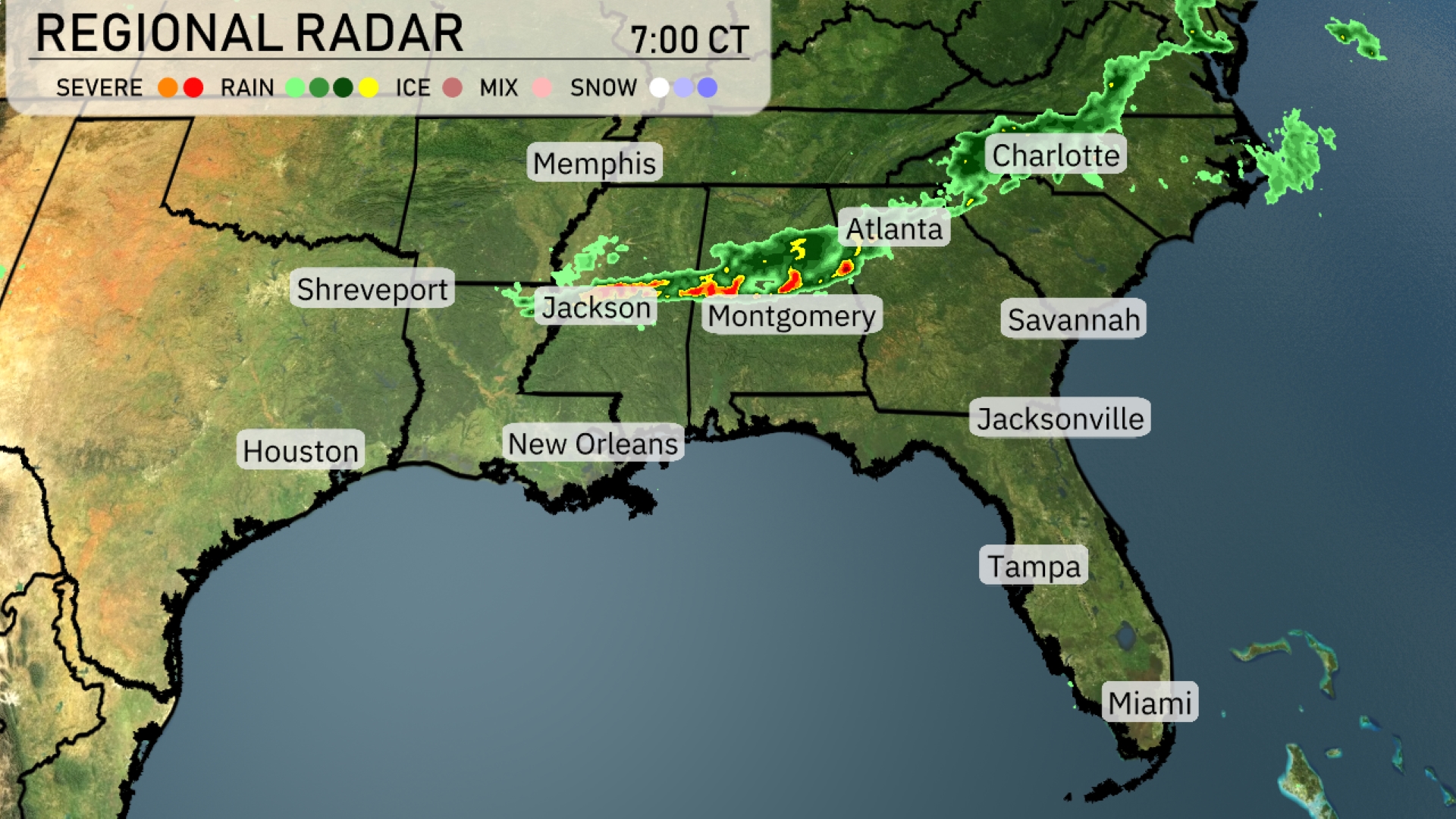
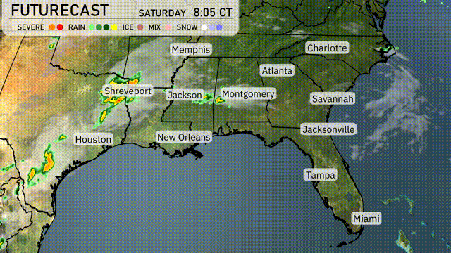
A line of storms stretches from Jackson to Atlanta, indicating intense weather activity. This storm system is bringing heavy rain and potential severe weather, especially around Montgomery. As the storms push eastward, Charlotte is next in line for rainfall. Meanwhile, Houston remains clear and dry, with no significant cloud cover or precipitation expected. Farther east, cities like Jacksonville and Tampa are under clear skies, enjoying calm conditions.
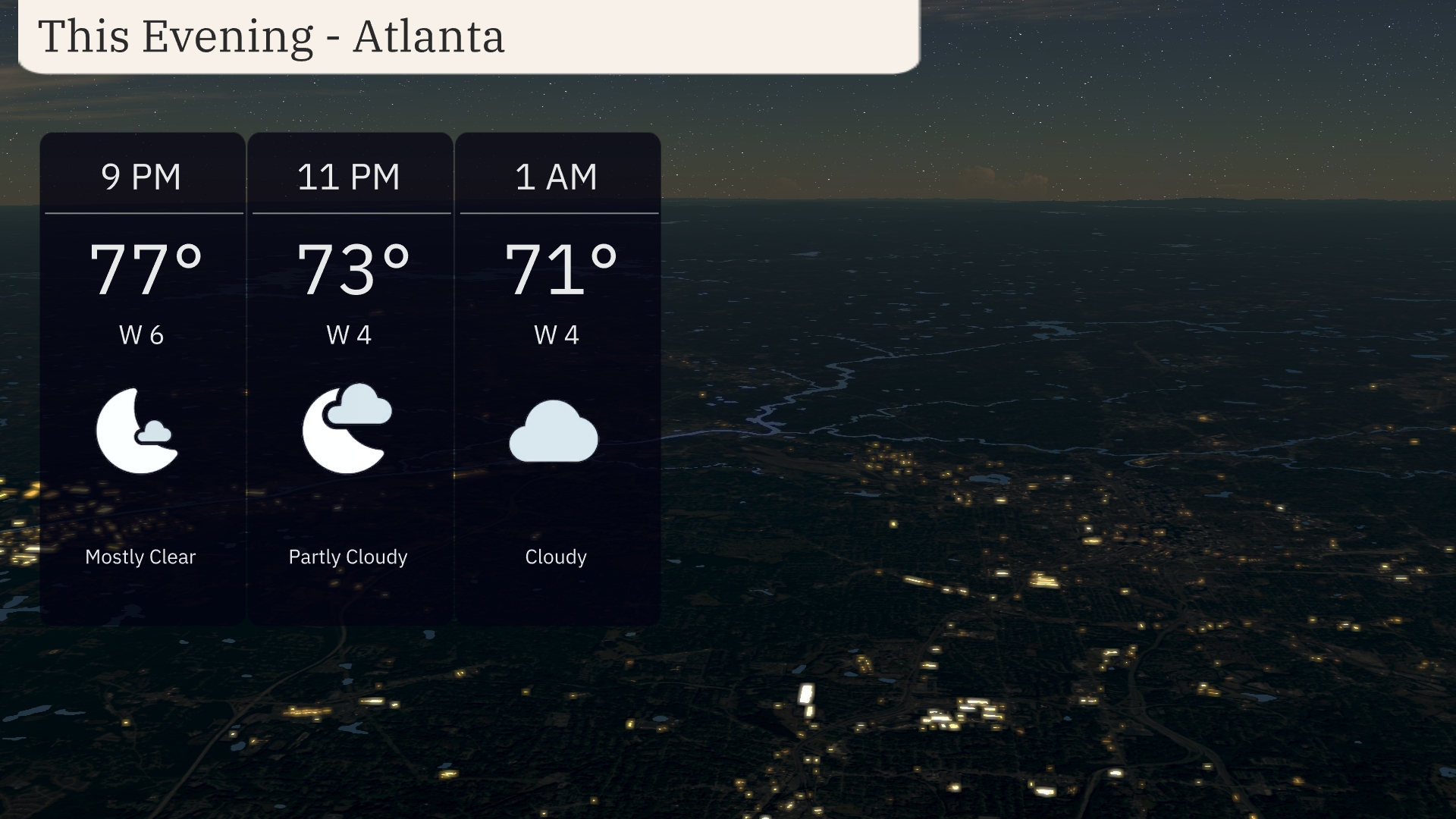
For this evening in Atlanta, temperatures begin at 77 degrees at 9 PM, gradually cooling to 71 degrees by 1 AM. The evening starts mostly clear, transitioning to partly cloudy conditions by 11 PM. Winds will be coming from the west at a gentle 6 mph, lowering slightly to 4 mph later in the evening. Expect increasing cloudiness into the late night as high pressure starts to shift.
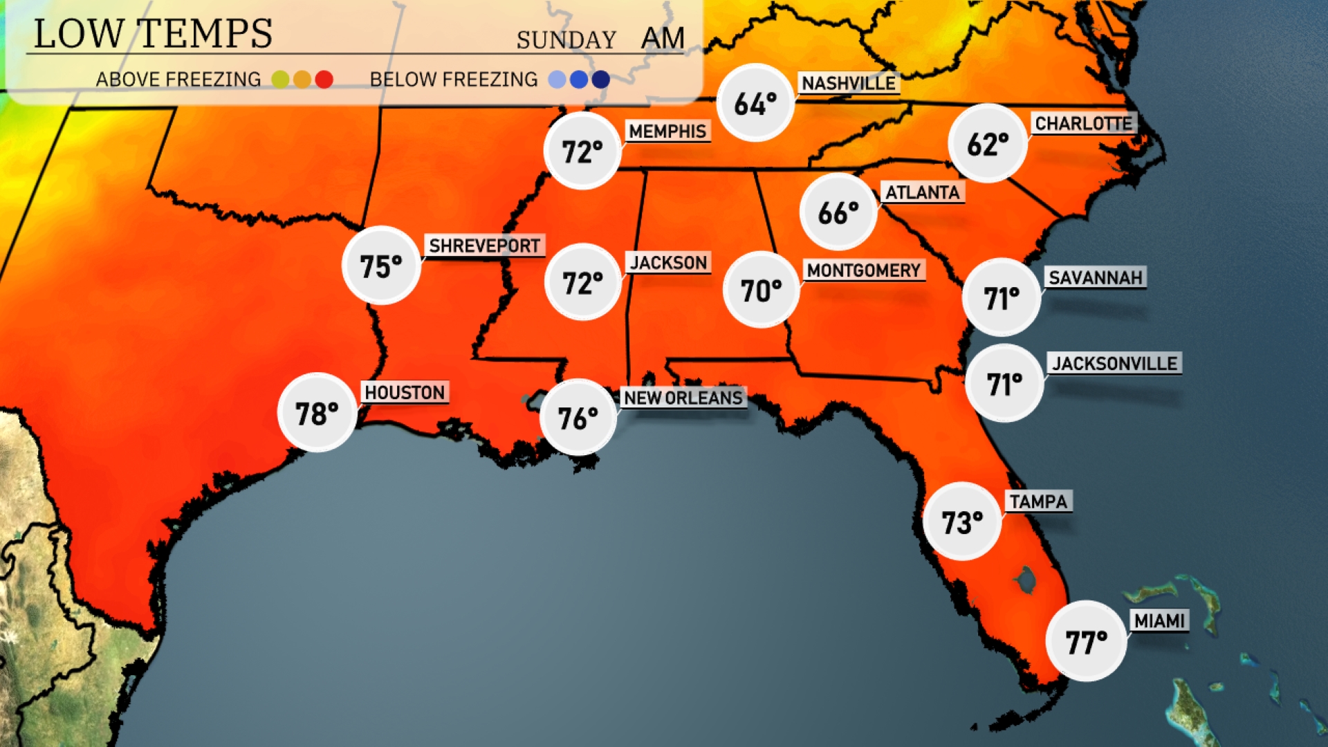
Tonight, the Southeast will experience mild temps, with a cooler trend impacting several cities. Expect lows around 64 degrees in Nashville and slightly cooler at 62 in Charlotte. Atlanta should see a low of 66, while Montgomery will dip to 70. Shreveport is forecasted to cool down to 75, and New Orleans will settle at 76 degrees. Overall, it’s a comfortable night ahead, but a slight chill is present as the cooler air begins to settle in.
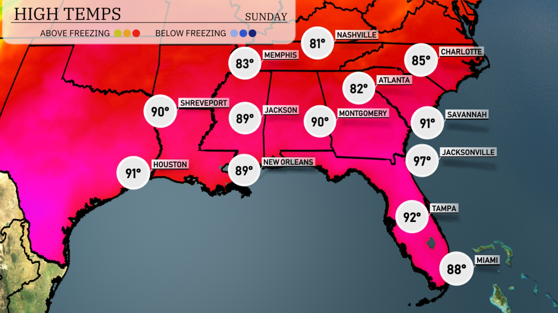
Tomorrow, the Southeast will see notably high temperatures as a warm air mass settles over the region. Atlanta is expected to reach 82 degrees, while further south, Jacksonville will soar to a toasty 97 degrees, well above average for this time of year. In New Orleans, a high of 89 degrees will be experienced, accompanied by warm, humid conditions. Montgomery will also hit 90 degrees, contributing to a pattern of sweltering temperatures across the area. Miami rounds out the warmth with a high of 88 degrees, maintaining seasonal trends.
A cold front approaches from the west, bringing an active weather pattern to the Southeast. Thunderstorms, some severe with damaging winds, are expected as the front advances from Shreveport and Jackson towards Montgomery and Atlanta by Saturday night. Heavy rainfall could lead to localized flooding, particularly in low-lying areas. Strong storms will affect New Orleans and extend to the Gulf Coast, with showers reaching Jacksonville and Savannah by Sunday morning.
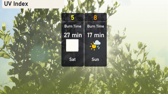
This Saturday, Atlanta will see a moderate UV index of 5, with a burn time of 27 minutes under direct sunlight. On Sunday, it climbs to a high of 8, reducing burn time to just 17 minutes. T
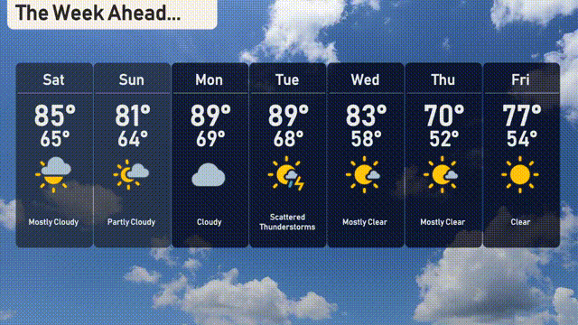
For the 7-day outlook in Atlanta:
Saturday: Mostly cloudy, reaching a high of 85 degrees with a low of 65.
Sunday: Enjoy partly cloudy skies with a high of 81 degrees and a low of 64.
Monday: Cloudy conditions prevail, with temperatures climbing to 89 degrees and a low of 69.
Tuesday: Scattered thunderstorms expected, with a high of 89 degrees and a low of 68.
Wednesday: Mostly clear skies, with temperatures peaking at 83 degrees during the day and dropping to 58 at night.
Thursday: Conditions remain mostly clear, as the high reaches 70 degrees and the low is 52.
Friday: Clear skies to close out the week, with a high of 77 degrees and a low of 54.