Sizzling Southwest: Navigating This Week’s Heat Wave and Sporadic Showers
By
Amy Freeze
Explore how the ongoing heat wave is shaping up across the Southwest, with a special focus on the cooling evening trends and unexpected showers. Stay prepared with our comprehensive guide.
This week, Salt Lake City and the surrounding Southwest are experiencing a mix of scorching temperatures and sporadic showers. Dive into our blog to understand how this affects you and how to stay safe!
From a high of 109 degrees in Phoenix to a soothing 75 in San Diego, the Southwest is a region of extremes this week. Salt Lake City sees a variable week with clear skies and temperatures ranging from the high 60s at night to nearly 100 degrees. An impending heat wave continues to grip the area, with an unusual spike in temperatures forecasted. Prepare for intermittent rains and a high UV index by following our safety tips featured in the blog.
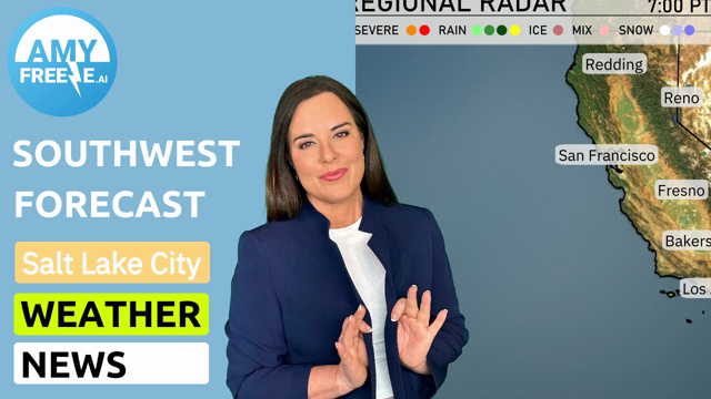
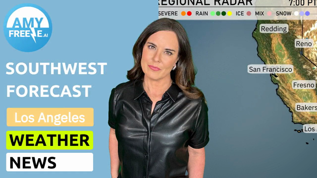
The regional radar shows clear skies over much of California and Nevada, but stormy weather is brewing to the north. Redding and areas towards Reno are experiencing rain, with potential for severe weather as storm systems push through. Salt Lake City is under cloudy conditions with rain expected, moving eastward. Meanwhile, sunny and dry conditions dominate across Southern California, including Los Angeles and San Diego, where the cool sea breeze is making it a perfect day for outdoor activities.
In Salt Lake City this evening, expect clear skies with temperatures gradually decreasing from 88 degrees at 9 PM to 78 degrees by 1 AM. Winds will shift from north-northwest at 9 mph to east-southeast at 6 mph. A calm and clear night sets the stage, perfect for any outdoor plans.
Tonight, Los Angeles will cool down to 58 degrees. San Diego is expecting a low of 63, while Bakersfield will drop to 74. Flagstaff is looking at a chilly 57 degrees, and Ely will see the coldest temperature in the region at 51 degrees. Las Vegas remains warm at 82 degrees, but the surrounding areas will definitely feel the crisp autumn air.
Tomorrow in Phoenix, expect a scorching high of 109 degrees, well above the seasonal average. Las Vegas will also see sweltering conditions with temperatures rising to 110 degrees. Bakersfield and Fresno are not far behind, both hitting 106 degrees. San Diego enjoys a milder day at 75 degrees, while San Francisco stays cooler at 66 degrees. Overall, a heat wave continues to grip much of the Southwest, fueling these above-average temperatures.
An area of low pressure will bring rain and thunderstorms to parts of Arizona and New Mexico starting Friday afternoon through Saturday. Expect heavy rainfall in localized areas, particularly along the border regions with potentially strong gusty winds. The system moves through quickly, with clearing skies anticipated by late Saturday. Temperatures will range from the low 80s to mid-90s, with cooler conditions following the rain. Keep an eye on any flood alerts as the storms pass through.
Salt Lake City will see a very high UV index of 9 on both Friday and Saturday, with a quick burn time of just 15 minutes in direct sunlight. It’s essential to take precautions, such as applying broad-spectrum sunscreen and wearing a hat and sunglasses. Avoid prolonged exposure, especially during midday when the sun is strongest!
For the 7-day forecast in Salt Lake City:
Friday: Clear skies with a high of 90 degrees and a low of 66 degrees.
Saturday: Clear and a bit warmer, reaching up to 94 degrees and cooling to 67 degrees at night.
Sunday: Mostly clear with temperatures climbing higher to 98 degrees and a low of 70 degrees.
Monday: Another mostly clear day, with a high of 97 degrees and a low around 72 degrees.
Tuesday: Partly cloudy skies, with a daytime high of 98 degrees and a low near 71 degrees.
Wednesday: Continue with partly cloudy conditions, reaching a high of 93 degrees and dropping to 68 degrees overnight.
Thursday: Partly cloudy with highs touching 96 degrees and lows dipping to 70 degrees.
Stay safe and enjoy your week!