The 2025 Southeast Storm Surge: Weather Patterns from Atlanta to New Orleans
By
Amy Freeze
Experience the dynamic weather across the Southeast, with a focus on the atmospheric shifts and temperature variations affecting the region this week.
Unpack the latest weather forecasts and alerts across the Southeast, from Atlanta’s partly cloudy skies and pleasant evenings to thunderstorms advancing eastward.
Explore the full spectrum of atmospheric conditions impacting the Southeast. Witness the transition from partly cloudy to clear skies in Atlanta, understand the implications of sizzling temperatures across cities like Shreveport and Jacksonville, and prepare for the dynamic changes a cold front will bring. Detailed weather patterns, safety tips for impending storms, and a 7-day forecast for Atlanta are included to help you plan your week with confidence.
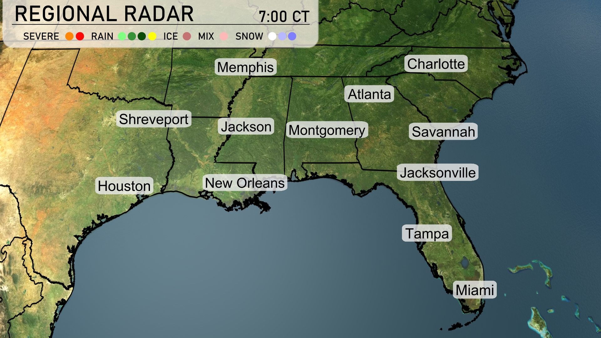
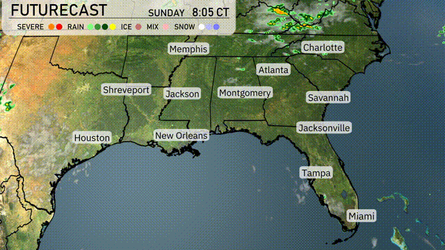
A strong line of thunderstorms is sweeping across Louisiana, with Shreveport experiencing intense storm activity. Moving eastward, New Orleans is seeing heavy rain, while Jackson is under a broader area of showers. Fuarther east, Montgomery and Atlanta are witnessing increasing cloud cover ahead of the approaching rain.
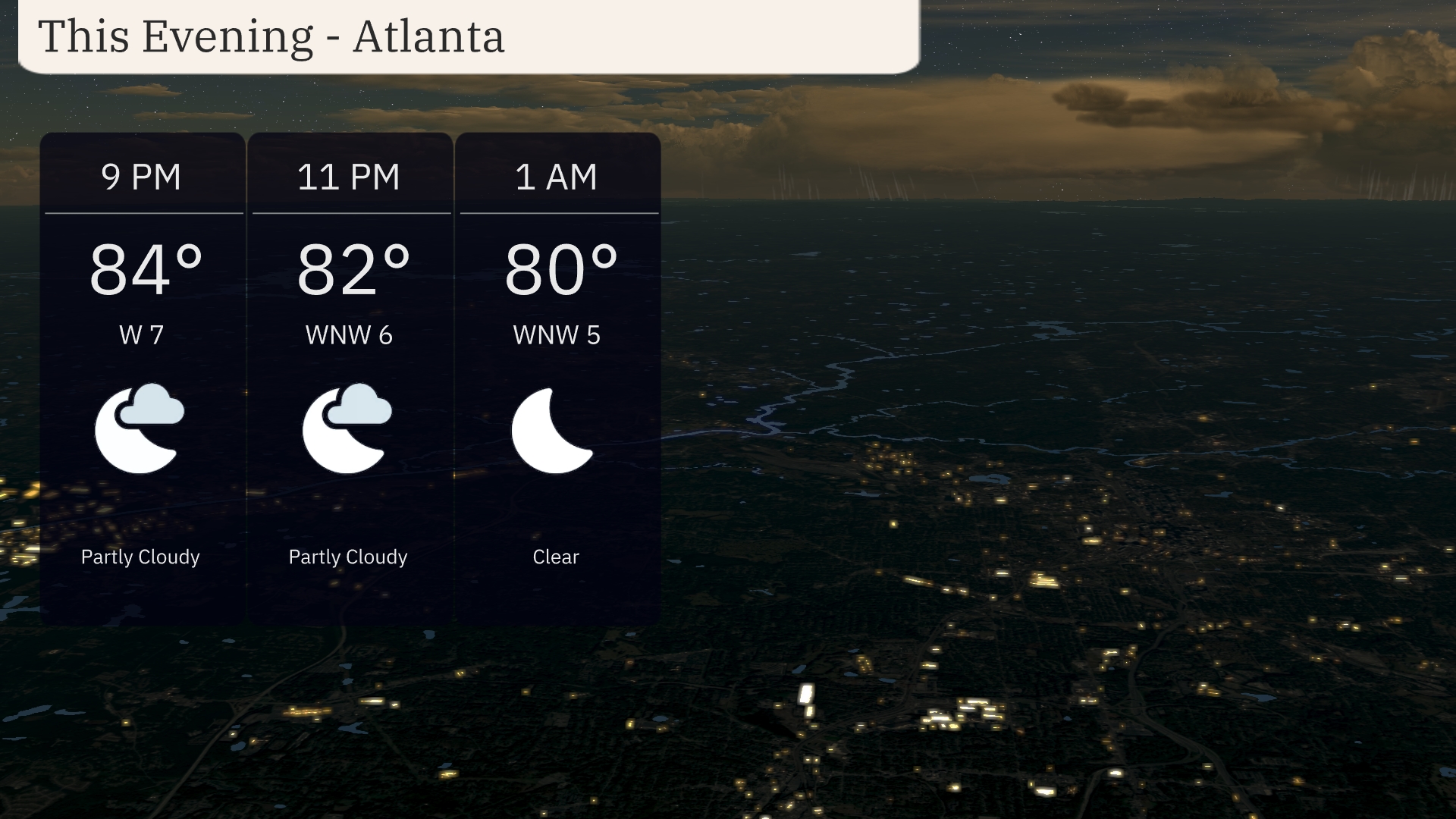
For this evening in Atlanta, partly cloudy skies will transition to clear by 1 AM. Temperatures gradually fall from 84 degrees at 9 PM to 80 degrees by 1 AM. Winds will be gentle, coming from the west initially at 7 mph and easing to 5 mph overnight. Expect a comfortable night with high pressure stabilizing the atmosphere.
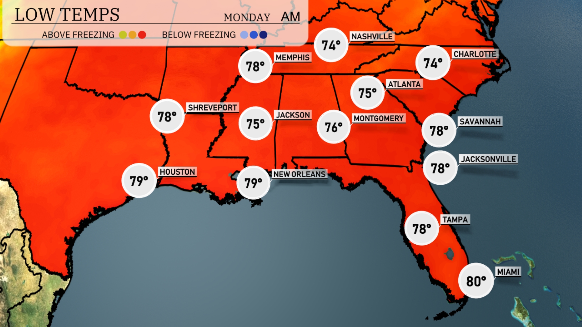
Tonight, Memphis will cool down to a low of 78 degrees. Nashville is expected to drop to 74, while Atlanta will see lows around 75. Expect New Orleans to remain warmer at 79 degrees, with Shreveport also staying mild at 78. Across the region, Jacksonville and Savannah will both finish the night at 78 degrees.
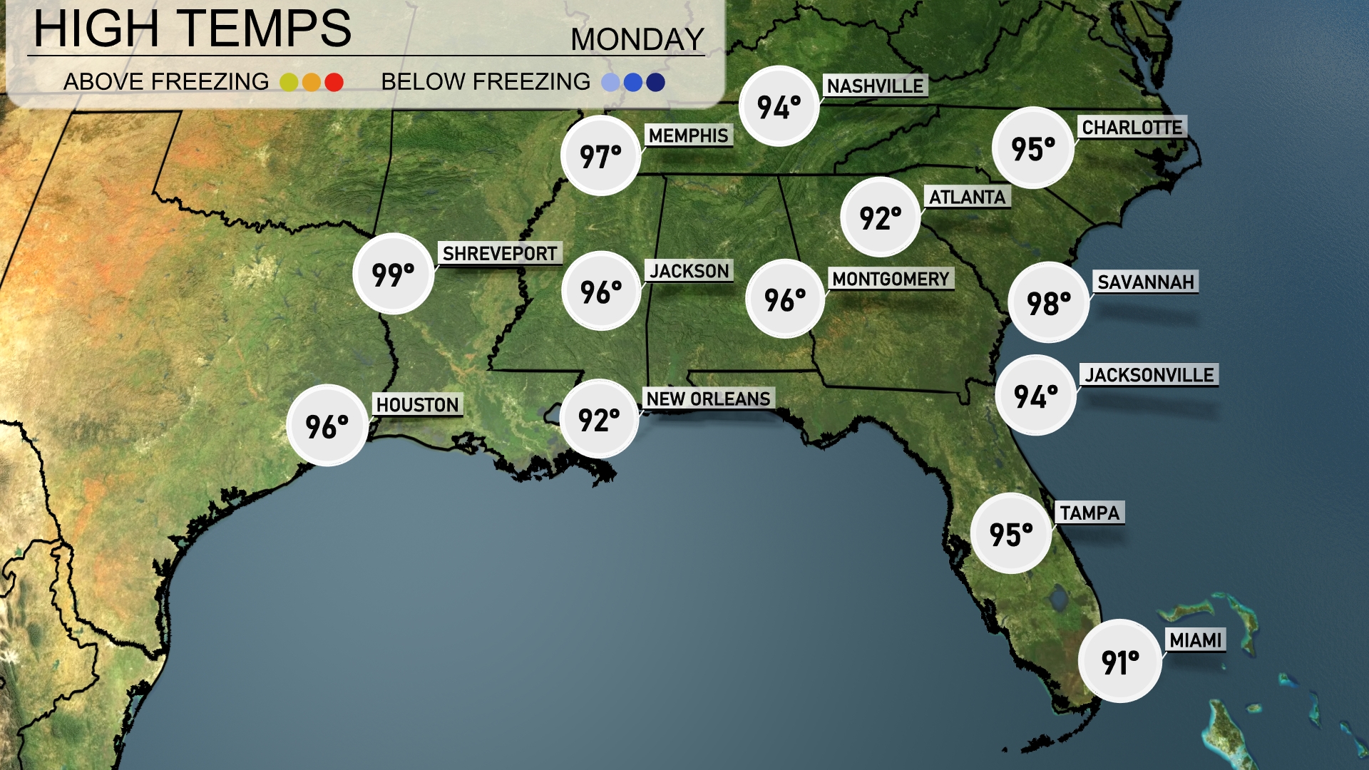
Tomorrow in the Southeast, temperatures are expected to soar with Savannah hitting a sizzling 98 degrees. Jacksonville follows closely at 94 degrees, while Atlanta manages a warm 96. New Orleans will see highs around 92 degrees, with Montgomery also reaching 96.
A developing cold front pushes eastward across the Southeast tomorrow, bringing active weather to the region. Morning showers are expected in Atlanta, with thunderstorms likely from New Orleans extending through Montgomery and into Jacksonville. Be prepared for downpours and localized flooding, especially in low-lying areas. Temperatures will drop noticeably behind the front, offering cooler, more comfortable conditions by Wednesday night. Pay attention to any severe weather alerts as storm systems continue to move through the area.
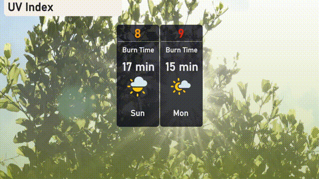
The UV index in Atlanta will be high today with a level of 8, meaning a burn time of just 17 minutes in direct sunlight. Tomorrow, it climbs to 9, with an even quicker burn time of 15 minutes!
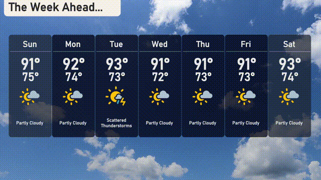
For the 7-Day Outlook in Atlanta:
Sunday: Partly cloudy skies with a high of 91 degrees and a low of 75 degrees.
Monday: Another partly cloudy day, the high reaches 92 degrees, while the low dips to 74 degrees.
Tuesday: Scattered thunderstorms expected with temperatures peaking at 91 degrees and a low around 73 degrees.
Wednesday: Partly cloudy skies again, with a high of 91 degrees and a low of 72 degrees.
Thursday: Expect partly cloudy conditions and a high of 91 degrees, with a low of 73 degrees.
Friday: Another partly cloudy day, high temperatures around 91 degrees, cooling to 73 degrees at night.
Saturday: Partly cloudy and slightly warmer, with a high reaching 93 degrees and a low of 74 degrees.