Weathering the Southeast: Amy Freeze’s Insightful Forecast and Miami’s Blue Skies
By
Amy Freeze
Explore a comprehensive weather update with Amy Freeze, covering the dynamic weather patterns in Miami and the Southeast, with special highlights on upcoming weather changes and safety tips.
Check out Amy Freeze’s take on the current weather in Miami and the broader Southeast region. From sunny skies to impending thunderstorms, stay prepared and informed with our detailed forecast.
Welcome to our detailed weather narrative with Amy Freeze, your trusted meteorologist. Today, we cover an extensive report, reviewing the pleasant conditions in Miami and moving across a spectrum of weather patterns affecting regions from Texas to the Carolinas. With precise temperature readings and forecasts, alongside safety advisories due to expected thunderstorms and high UV indices, this blog ensures you stay ahead of any weather changes. Explore measures to enjoy safe outdoors and safeguard against potential adverse weather impacts.
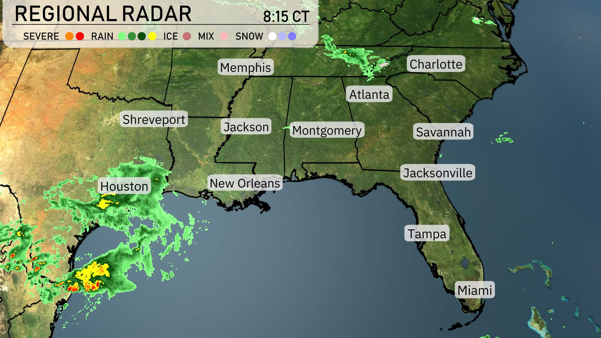
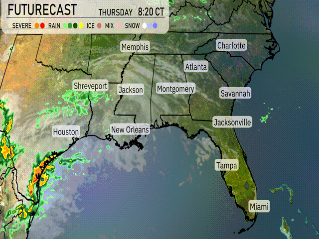
The radar reveals a dynamic weather pattern across the Southeast. Houston and areas along the Texas coast are experiencing a substantial amount of rain, with showers extending toward Shreveport. As the system moves northeast, it’s casting rainy conditions over central Mississippi, affecting Jackson with moderate precipitation. The skies over Memphis remain clear, providing a reprieve for the region. Farther east, the Carolinas, including Charlotte, are under increasing cloud cover as rain approaches from the southwest. Coastal cities like Savannah and Jacksonville are currently enjoying clear skies, making for pleasant conditions in these areas.
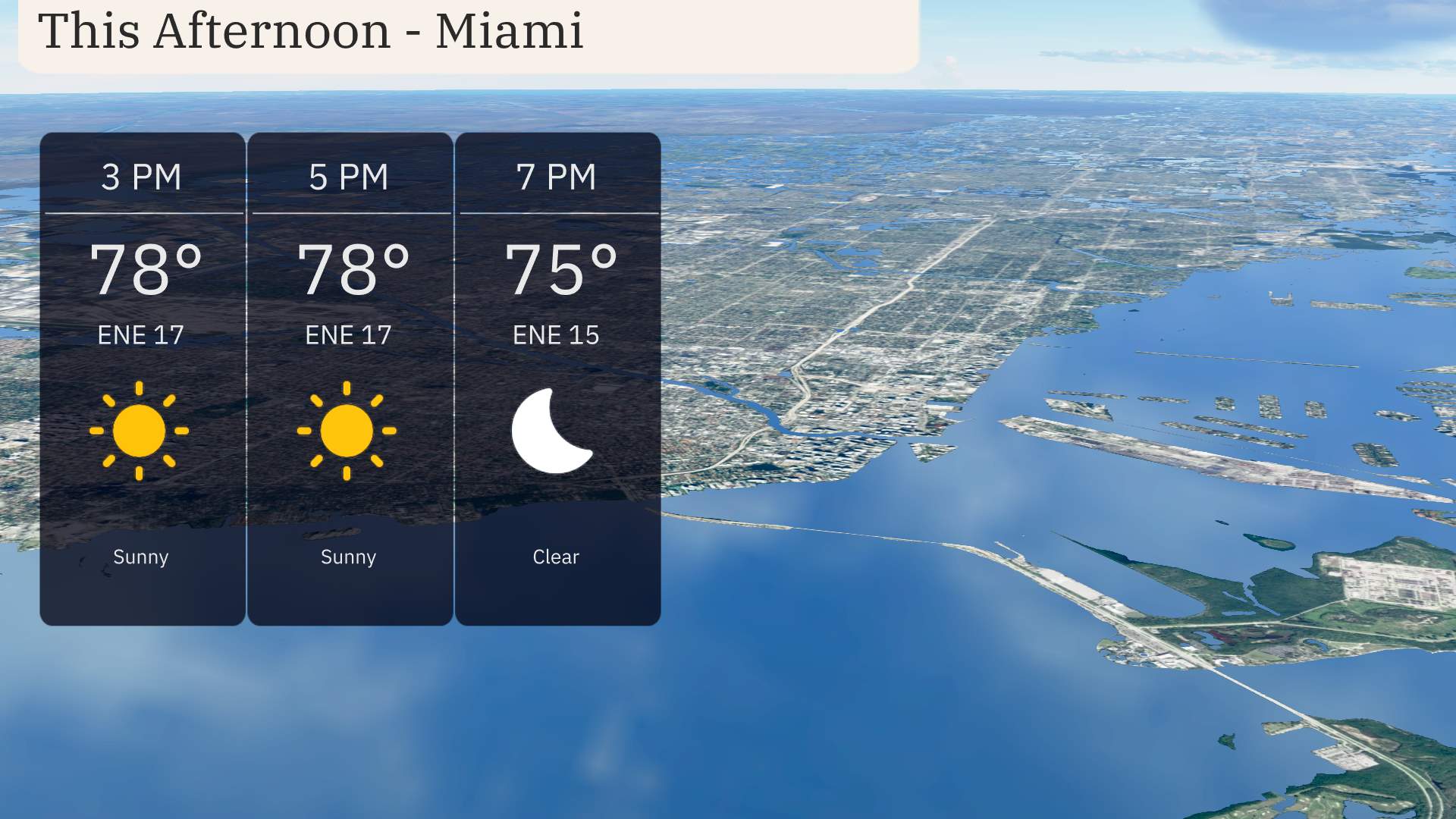
Miami temperatures this afternoon will maintain steady at 78 degrees with an east-northeast wind blowing at 17 miles per hour. Expect sunny skies through the late afternoon, providing a perfect opportunity to enjoy the outdoor activities. Toward the evening, winds will ease slightly as the skies clear, allowing temperatures to drop to 75 degrees by 7 PM.
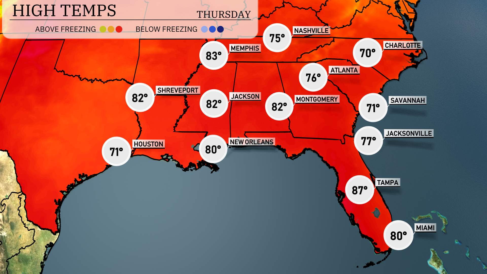
Let’s take a look at the afternoon high temperatures across the Southeast today. It’s a warm and sunny scene in Shreveport with a high of 82 degrees. In Jackson, you can expect a similar temperature, also hitting 82. Over in New Orleans, it’s slightly cooler at 80 degrees.
Moving to the eastern part of the region, Montgomery reaches a high of 82, while Atlanta is a bit more moderate at 76. Down in Florida, Tampa is feeling the heat with a high of 87, making it the warmest spot today. Miami enjoys a comfortable 80 degrees, and Jacksonville sits at a balmy 77.
Lows in the Southeast starting with Memphis at 33 degrees. Nashville will see lows around 35 degrees. Jackson is forecasted for 37 degrees, while Montgomery will register 36 degrees. Atlanta should wake up to 40 degrees. Over in Tampa, expect a milder 55 degrees, with Miami remaining warmer at 63 degrees. This cool air pattern will be noticeable, especially in the Tennessee River Valley.
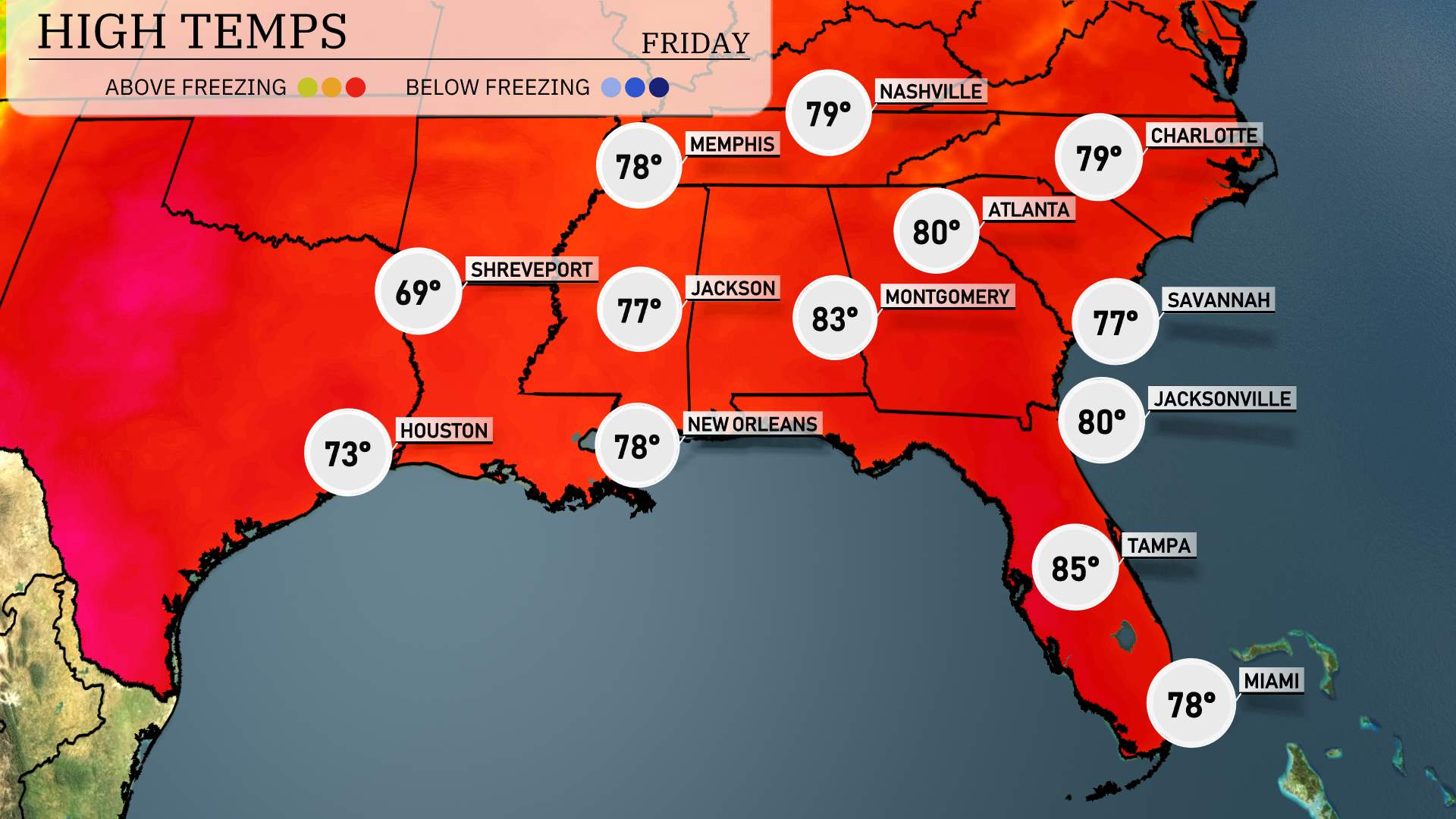
High temperatures for tomorrow in the Southeast are shaping up to be notably warm. In Atlanta, expect a high of 80 degrees, while further south in Montgomery, it will be even warmer at 83 degrees. Over in Jackson, temperatures will reach 77 degrees, and New Orleans is forecasted for a high of 78 degrees.
Moving into Florida, Tampa will be the warmest city with a high of 85 degrees, and Miami will reach 78 degrees. Coastal areas will benefit from warm air bringing above-average temperatures across the region, which could result in some humidity and a slight chance of afternoon showers in isolated areas.
“A strong weather system is moving east across the Southeast, bringing a mix of rain and thunderstorms. Expect severe weather from Houston to New Orleans as the day progresses, with possible heavy downpours and gusty winds. This line of storms will shift toward Shreveport and Jackson by mid-day, reaching Alabama and Georgia Thursday evening. Be prepared for intermittent heavy rainfall, particularly over Atlanta and farther east overnight. Stay alert for local weather warnings and be cautious of potential flooding risks in lower-lying areas. Temperatures may dip slightly across the region following the storm passage.”
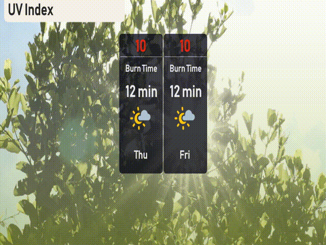
“The UV index in Miami will be a very high 10 on both Thursday and Friday, with potential sun exposure risks. Expect burn times in just 12 minutes under the sun’s intense rays.”