Storm Surge: Amy Freeze’s In-Depth Look at Southeast Weather Dynamics
By
Amy Freeze
Join Amy Freeze as she dissects the fluctuating weather conditions sweeping across the Southeast, from calm mornings in Atlanta to stormy nights in Miami.
Experience a whirlwind of weather patterns across the Southeast with Meteorologist Amy Freeze. From stormy showers to sunny skies, stay informed and prepared with our comprehensive guide.
Welcome to your essential weather briefing for the Southeast from renowned meteorologist Amy Freeze. This week, we’re seeing a roller coaster of climate conditions—partly cloudy mornings in Atlanta, intense storms rolling from Alabama to the Carolinas, and mild, sunny days down in Florida. Prepare for weather shifts with daily updates and expert insights, ensuring your safety and helping you make the most of the weather ahead. Visit our full blog for a deeper dive into the regional forecast.
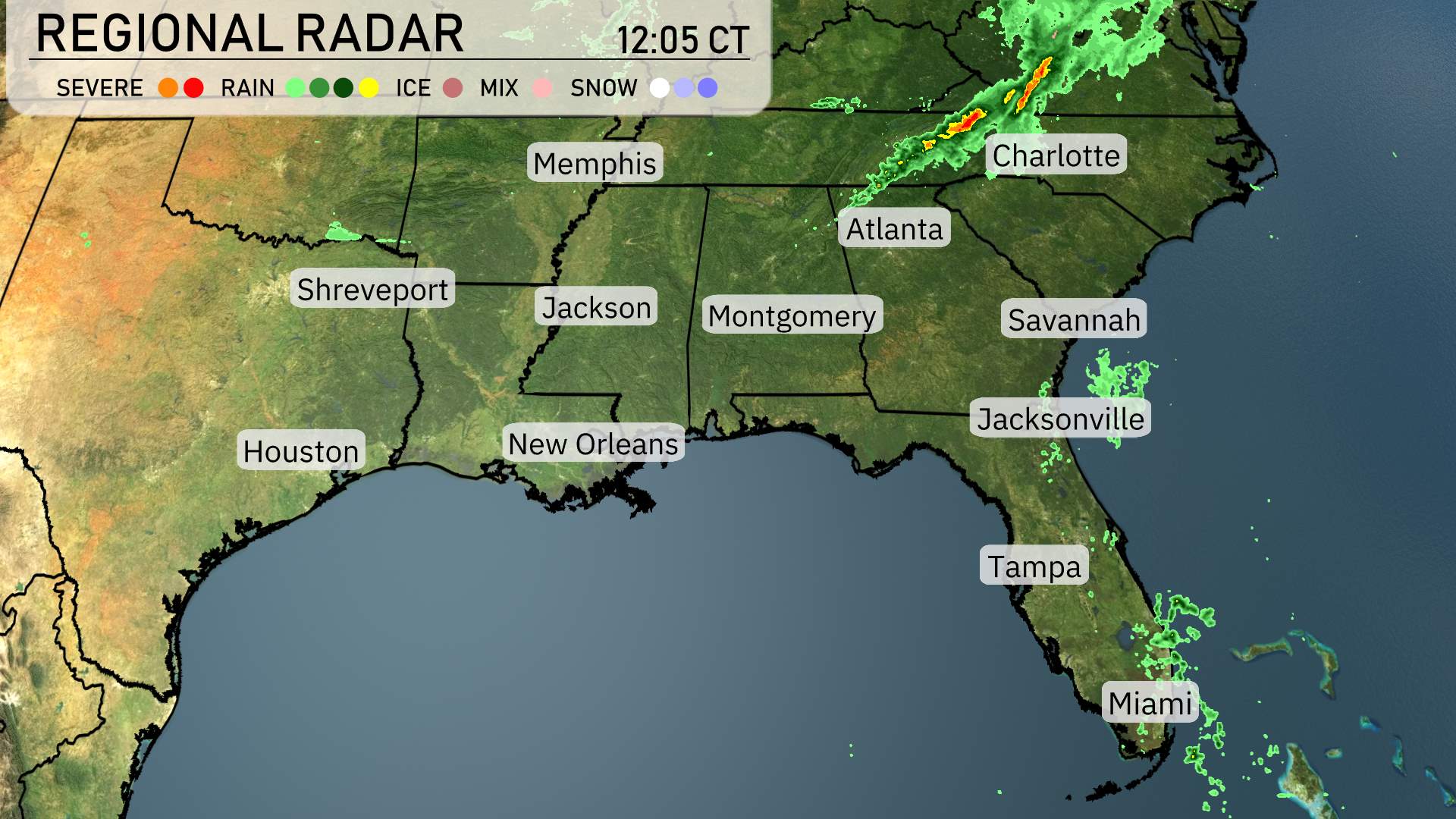
In today’s regional radar overview, the Southeast is experiencing a variety of weather patterns. A line of storms is currently making its presence felt from northern Alabama moving northeast towards the Carolinas. This system is particularly impacting areas around Charlotte with significant rainfall and thunderstorm activity.
Farther west, the skies over Mississippi and Louisiana, including cities like Jackson and Shreveport, remain relatively clear, with only light scattered cloud cover. Atlanta is on the cusp of rainfall as the weather system approaches, bringing with it potential showers later today.
To the south, Georgia’s coastal regions, including Savannah, are currently enjoying dry conditions, but cloud cover is beginning to increase as rain draws nearer from the northwest. Farther south, Jacksonville sees some light rain activity pushing through, while Tampa and Miami remain dry and mild for now.
Atlanta’s morning forecast ushers in cool temperatures starting at 50 degrees at 8 AM, gradually climbing to 55 degrees by 10 AM. Winds from the west-northwest will be gentle at 7 miles per hour, increasing to 14 miles per hour through the morning.
High temperatures for tomorrow in the Southeast are shaping up to be quite warm, with many locations experiencing above-average readings.
In Houston, expect a sizzling 88 degrees, marking one of the hottest spots in the region. Shreveport will see a high of 81 degrees, while Jackson reaches 75 degrees. New Orleans is also warming up to 79 degrees, and Montgomery will experience a mild high of 72 degrees.
Atlanta is set for a comfortable 66 degrees, while Nashville lags a bit behind at 61 degrees. Over in Florida, Jacksonville will enjoy a balmy 82 degrees, and Miami will hit 81 degrees.
A cold front is set to influence the Southeast region tomorrow, bringing active weather conditions. Expect strong thunderstorms from New Orleans to Miami. As this front moves eastward throughout the day, areas such as Atlanta and Charlotte will see developing storms during the late afternoon, possibly continuing into the evening. These storms could include heavy rainfall and gusty winds, so remain alert for weather advisories. Temperatures will be a bit more mild following the front, offering some relief by the weekend. In contrast, southern Florida, particularly from Jacksonville to Miami, may experience periodic downpours and isolated thunderstorms.
The UV index in Atlanta will be high over the next two days. On Thursday, with a UV index of 8, sun exposure can cause burns in just 17 minutes. As we move into Friday, conditions remain similar with a UV index of 8 and the same burn time. If you’re planning outdoor activities, be sure to wear sunscreen and protective clothing to stay safe under the sun!
For the 7 Day Outlook in Atlanta:
Friday: Thunderstorms early, with a high of 65 degrees, cooling down to 42 at night.
Saturday: Enjoy partly cloudy skies with a high of 64 degrees and a low of 40.
Sunday: Clear skies dominate the day, reaching a high of 73 degrees and dipping to 49 overnight.
Monday: Expect more clear skies, warming up to 85 degrees with a low of 57.
Tuesday: Partly cloudy conditions with temperatures hitting 70 degrees during the day and 45 at night.
Wednesday: Skies clear up with a high of 72 degrees and a low of 48.
Thursday: Partly cloudy once again, with temperatures peaking at 76 degrees and a low of 56.
Hope that helps!