Explore a detailed breakdown of the Southeast's dynamic weather patterns, featuring expert analysis by Meteorologist Amy Freeze. From stormy forecasts in Charlotte to sunny spells in Miami, find out what the weather has in store for the region.
Meteorologist Amy Freeze tracks stormy conditions and pleasant temperatures across the Southeast. Get the latest updates on weather trends and what to expect in your city!
Meteorologist Amy Freeze provides an insightful analysis of the weather patterns across the Southeast. As storms sweep from southwest to northeast, major areas face diverse weather conditions. Atlanta sees cloudy skies and potential showers, while clear skies brighten Miami and Tampa. Tune in for hourly temperature updates, severe weather alerts, and practical tips to navigate the changing weather. Whether it’s the storm risks from New Orleans to Jacksonville or the cool nights ahead, Amy brings clarity and precision to your weather needs. This comprehensive guide offers all you need to prepare for the week, with detailed temperature breakdowns and safety tips.
A line of intense storms is sweeping from southwest to northeast, impacting major areas across the Southeast. Charlotte is experiencing strong storms, while the weather pattern stretches from Savannah up through Jacksonville, causing significant rainfall and potential lightning. Atlanta is witnessing cloud cover moving in with the chance of showers developing soon. Meanwhile, in Southern Georgia, rain is extending further southward, bringing wet conditions to areas approaching Montgomery. Coastal regions from Miami to Tampa are enjoying clearer skies with only slight cloud interference before the weather fronts move eastward.
This afternoon in Atlanta, temperatures are peaking at 71 degrees by 3 PM, cooling gradually to 68 degrees by 5 PM, and settling at 62 degrees by 7 PM. Throughout the afternoon, partly cloudy skies will accompany a westerly wind shifting from 15 miles per hour early to around 11 miles per hour later in the afternoon.
Let’s take a look at today’s high temperatures in the Southeast. It’s a pleasant day in Shreveport with a high of 68 degrees. Houston warms up nicely, hitting 77. Moving over to Jackson, we’re seeing a cooler high of 61. Meanwhile, Atlanta is enjoying a comfortable 71 degrees. Farther down the coast, Montgomery reaches 71 as well, while Savannah and Jacksonville each see pleasant temperatures of 72 and 77 degrees, respectively. In Florida, Tampa is warmer at 81 degrees, and Miami leads the pack with a high of 82, thanks to plenty of sunshine. Enjoy the beautiful weather, Southeast!
Tonight, the Southeast faces a cold night with temperatures dipping into the low 30s in some areas. Nashville will hit 41 degrees, while Memphis will see a low of 52. Expect cooler conditions in Montgomery at 38 and Jackson at 44. Atlanta will also experience a chilly night with a low of 38. Further south, New Orleans will cool to 50 degrees, while Tampa is set for a low of 49. Jacksonville rounds out the region with a morning low of 46, providing a noticeable dip compared to recent temperatures.
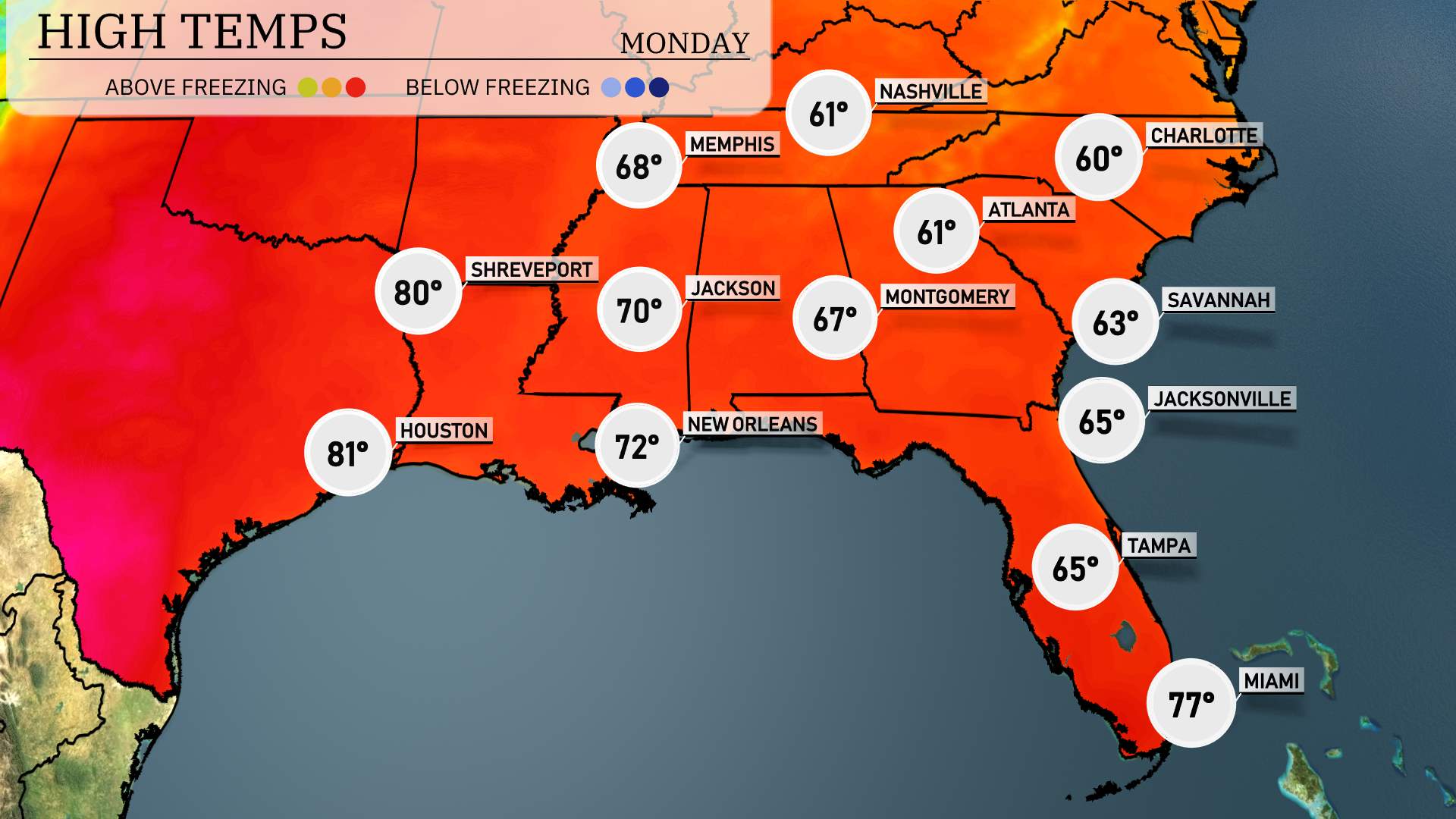
High temperatures in the Southeast tomorrow will feature warmer readings as a high-pressure system moves through the region.
Houston will reach a warm 81 degrees. Shreveport is also set to enjoy a high of 80 degrees. New Orleans warms up to 72 degrees, while Jackson hits 70 degrees, providing pleasant conditions.
Atlanta and Montgomery see slightly cooler temperatures, topping out at 67 degrees and 61 degrees, respectively.
Memphis is forecasted for a high of 68 degrees, indicative of near-average readings. Jacksonville expects a high of 65 degrees, while Miami continues to feel the warmth with a high of 77 degrees.
Overall, much of the Southeast will experience above-average temperatures, making for a warm day ahead.
“Prepare for a mild start to the day across the Southeast with a mix of sunshine and clouds. By afternoon, a series of thunderstorms will develop along the Gulf Coast, extending from New Orleans to Jacksonville, where heavy rainfall and gusty winds are anticipated. The Storm Prediction Center’s outlook places parts of Georgia and the Carolinas under a severe weather risk, with the potential for isolated tornadoes. Rainfall amounts could top two inches in some spots, leading to localized flooding concerns through Tuesday. As the system progresses eastward, skies clear and cooler air filters in, setting the stage for a pleasant mid-week.”
“The UV index in Atlanta will be high today with a level of 7. Expect to burn in about 20 minutes if you’re in direct sunlight. Sunscreen and protective clothing are a must! Keep in mind that UV exposure remains high tomorrow as well, so take precautions for extended time outdoors.”