Navigating Through Storms: A Comprehensive Southeast Weather Guide by Amy Freeze
By
Amy Freeze
Explore a detailed weather forecast for the Southeast, including temperature trends and storm alerts, provided by trusted meteorologist Amy Freeze.
Get the latest updates on weather conditions across the Southeast from meteorologist Amy Freeze. From storm alerts in Florida to sunny days in Memphis, find all the essential forecasts you need.
Meteorologist Amy Freeze provides an in-depth look at the upcoming weather conditions in the Southeast. Expect detailed analysis on cloud cover in Atlanta, storm paths along the Florida coastline, and temperature fluctuations throughout the region. Tune in for updates on storm severity, safety tips, and how these conditions could affect your daily activities.
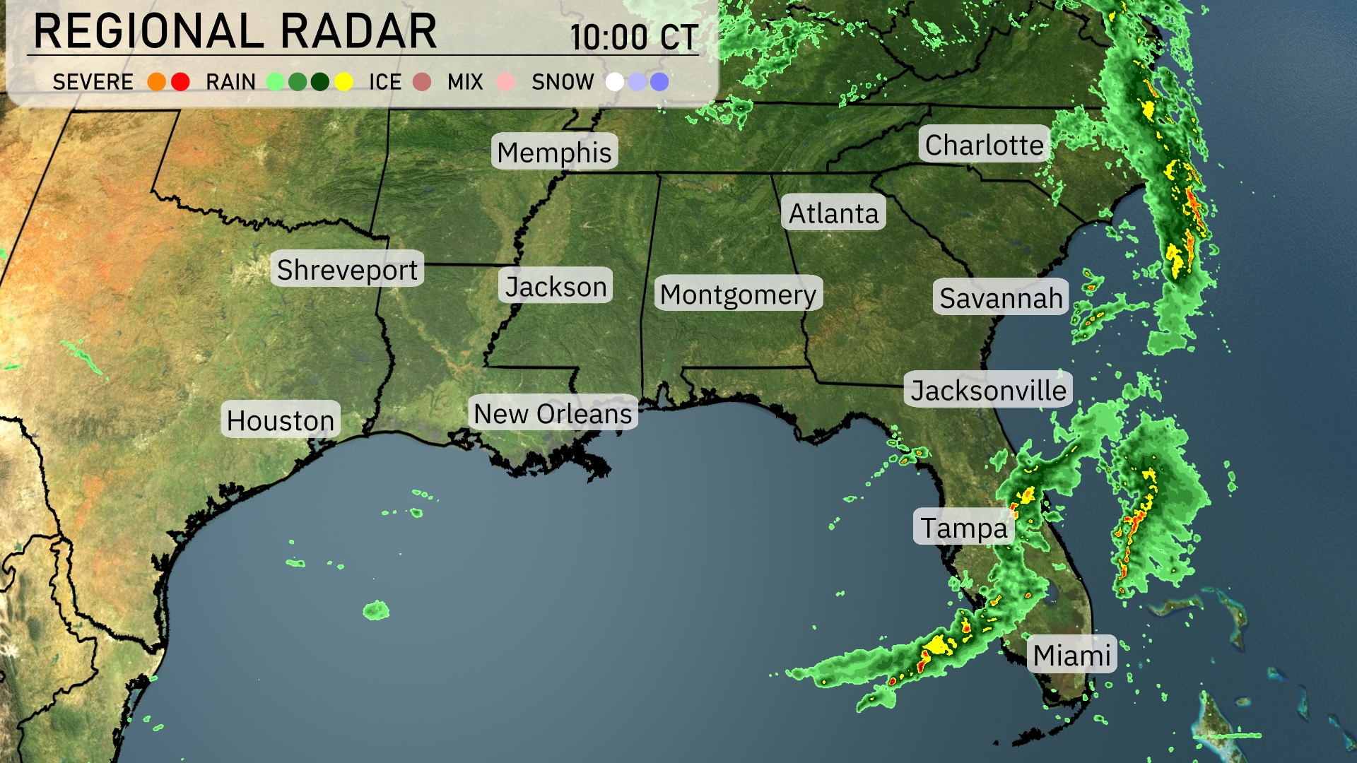
A robust line of thunderstorms stretches along the Florida coastline, bringing heavy rain and lightning from Miami up through Jacksonville. As the rain band makes its way northeast, it looks poised to affect Savannah and could reach as far north as Charlotte later today. Inland areas, like Atlanta, are experiencing increased cloud cover, with rain showers expected to move in from the west. Light rain showers extend into parts of Alabama, with Montgomery seeing some wet conditions. Memphis and Shreveport remain dry under mostly clear skies, enjoying a break from the precipitation.
For this evening in Atlanta, temperatures gradually decrease from 62 degrees at 9 PM to 55 degrees by 1 AM. Skies will remain mostly clear with a gentle northwest breeze, starting at 5 miles per hour and calming down to 3 miles per hour later in the night.
Tonight in the Southeast, expect notably cooler temperatures as a cold front moves through. Memphis will see a low of 47 degrees, while Nashville dips to 50. Atlanta is forecasted to cool down to 53 degrees, with Montgomery also at 53. Over in Jackson, it will be a bit milder at 58, while the warmer spots like New Orleans will rest at 70. Expect a pleasant 63 in Jacksonville, with more comfortable lows throughout Florida.
Tomorrow’s high temperatures in the Southeast are shaping up to be quite warm, with Jacksonville reaching an impressive 88 degrees. Atlanta will see a milder high of 71 degrees, while Montgomery also hits 79. Notably, New Orleans is expected to climb to 81 degrees, and Shreveport matches that with a high of 81 degrees as well. With most areas experiencing above-average temperatures, expect a warm, sunny day influenced by a stable high-pressure system.
A line of storms moves across the Southeast tomorrow, with strong thunderstorms expected from New Orleans to Montgomery. Heavy rainfall at times will impact Jacksonville and stretch into Savannah by late afternoon. A cold front passes through Atlanta during the early commute, bringing the potential for heavy downpours and gusty winds. Keep an eye on the weather as storms could approach severe limits, especially in areas of Mississippi and Alabama. Temperatures in the region remain cool behind the front, with improving conditions by late Wednesday.
The UV index for Atlanta will reach a high of 9 on Sunday, so it’s vital to prepare for sun protection, as burns can occur within 15 minutes in direct sunlight. On Monday, the index will slightly decrease to 8, with a burn time of around 17 minutes.
For the 7-day outlook in Atlanta:
Sunday: Mostly clear with a high of 72 degrees and a low of 47.
Monday: Clear skies continue, reaching 72 degrees for the high, with an overnight low of 48.
Tuesday: Showers late in the day, expect highs around 80 degrees and a low of 58.
Wednesday: Showers with a daytime high of 70 degrees and a low of 59.
Thursday: Scattered thunderstorms are likely, climbing to 75 degrees for the high and 60 degrees at night.
Friday: Showers with temperatures peaking at 73 degrees and dipping to 57 overnight.
Saturday: Showers persist with a high of 64 degrees and a cool low of 55.