Calm Before the Storm: Southeastern Weather Insights with Amy Freeze
By
Amy Freeze
Join Amy Freeze as she navigates the serene skies and impending storms brewing in the Southeast, providing a comprehensive outlook for the week, from Miami’s mild evenings to the series of cold fronts affecting the region.
Meteorologist Amy Freeze brings you the latest updates on Southeastern USA weather. Enjoy Miami’s mostly clear skies or prepare for the storm in Louisiana. Stay weather-ready!
Meteorologist Amy Freeze here, delivering your detailed weekly weather forecast. Miami enjoys partly cloudy skies with a fresh breeze, while dynamic weather patterns across the Southeastern U.S. bring rain and storms. Follow for a full breakdown of daily conditions, safety advisories, and tips to enjoy or prepare for the weather each day. This week, we’ll see temperatures fluctuating and potentially severe weather in some regions. Stay updated and safe!
On the Regional Radar for the Southeast, we have quite a dynamic weather pattern today. A line of showers is making its way from the Gulf of Mexico, moving northward and bringing rain into Houston. This system continues to push northeast, affecting Shreveport and Jackson with moderate rain. Memphis is under a deluge from the same rain activity feeding up from Louisiana.
Farther to the east, New Orleans is experiencing a surge of rain showers associated with this developing system. As clouds build, we see potential for more rain moving into Montgomery. Cities like Savannah, Charleston, and Tampa are enjoying clear skies,. East towards Jacksonville, a few scattered showers are interrupting an otherwise mild day.
For this evening in Miami, anticipate partly cloudy skies with temperatures holding steady at 74 degrees from 8 PM through midnight. Winds will gradually shift from east at 19 miles per hour to east-southeast at 17 miles per hour as the night progresses. Expect mostly cloudy conditions as we move closer to midnight, adding a bit of a breezy feel to your evening plans.
Tonight, the Southeast will be experiencing a dip in temperatures as a cold air mass moves in. Expect a chilly night with lows reaching 33 degrees in Nashville, signaling a significant drop. Memphis will see a low of 36, while Shreveport will cool down to 43. In Jackson, temperatures will settle at 41 degrees. Atlanta will have a low of 39, and farther south in Tampa, expect a mild 55 degrees. Miami rounds out the night with a relatively warm 64 degrees, but still noticeably cooler than previous nights.
For tomorrow in the Southeast, we’re expecting some warm temperatures across the region. Houston will lead the pack with a high of 83 degrees, while Shreveport isn’t far behind at 81 degrees. Over in New Orleans, the high reaches 74, with Montgomery expected to hit 80 degrees.
In the Atlanta area, temperatures are set to reach 78 degrees, while Savannah warms up to 76. Jacksonville will see a high of 79 degrees. Moving east, Charleston edges up to 79 degrees as well. Miami is on track for a balmy high of 87 degrees, significantly above the average for this time of year.
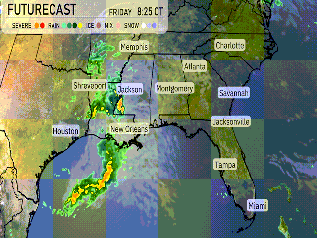
“On the Southeast futurecast for Friday, a line of strong storms is moving through portions of Louisiana and Mississippi, bringing heavy rain and potential flooding, especially around Shreveport and Jackson. Expect rain showers to continue into the evening, reaching areas like Montgomery and Atlanta by late Friday night. As this system progresses eastward, keep an eye on localized severe weather risks, including strong winds and isolated tornadoes. Temperatures will remain warm across the region before cooling behind the front on Saturday.”
The UV index in Miami is set to be very high on Friday with a level of 9, indicating a burn time of just 15 minutes in direct sun exposure. Moving into Saturday, the UV index climbs further to an extreme level of 10, with a burn time of only 12 minutes.
For the 7-Day Forecast in Miami:
Friday: Partly cloudy skies with a high of 78 degrees and a low of 73.
Saturday: Look for isolated thunderstorms with a high around 80 degrees and a low of 74.
Sunday: Scattered thunderstorms expected with temperatures reaching 81 degrees and dipping down to 73 overnight.
Monday: Clear skies with a lovely high of 82 degrees and a low near 73.
Tuesday: Another clear day with a high of 83 degrees and a low of 74.
Wednesday: Mostly clear, enjoy a high of 82 degrees, cooling down to 74 at night.
Thursday: Continue with mostly clear skies, a high of 82 degrees and lows around 74.
Enjoy the week, and stay weather-ready!