Amy Freeze’s Essential Southeast Weather Update for a Stormy Evening
By
Amy Freeze
Meteorologist Amy Freeze delivers a detailed forecast for Atlanta and the broader Southeast region. Stay updated with the latest temperatures and storm warnings.
Dive into Amy Freeze’s comprehensive weather update for the Southeast on a diverse evening weatherwise—from clear skies in Atlanta to storm alerts across the region.
Greetings, everyone! This is Amy Freeze with a comprehensive forecast for the Southeastern states. Tonight, expect varying conditions across the area, from clear skies to storms rolling in. Whether you’re in Atlanta enjoying serene weather or in Charlotte bracing for rain, I’ve got all the details. Plus, insights on Florida’s warm, breezy evening and what to expect over the next few days. Don’t forget the sunscreen with high UV indexes around! For a detailed 7-day forecast for Atlanta, visit our updated blog at https://amyfreeze.ai/.
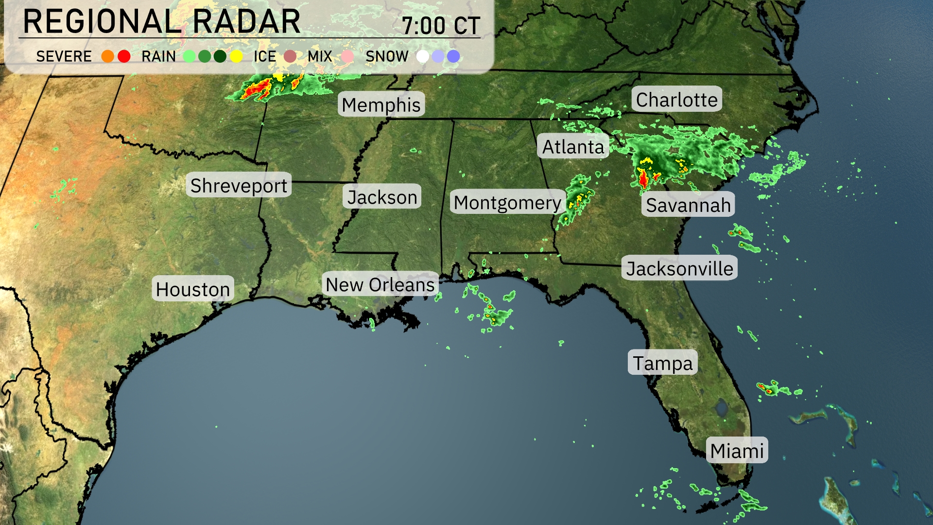
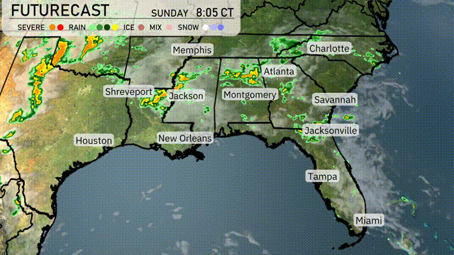
A cluster of strong storms is currently over Charlotte and moving northeastward, bringing rain and possible severe weather. Atlanta is experiencing moderate rain showers, while Savannah is also seeing a band of thunderstorms. Rain extends further into the Carolinas, with rain clouds spreading towards the coastline. Meanwhile, New Orleans and Houston enjoy clearer conditions, with some patchy clouds. Miami and Tampa are relatively dry, but some scattered light showers are drifting over northern Florida.
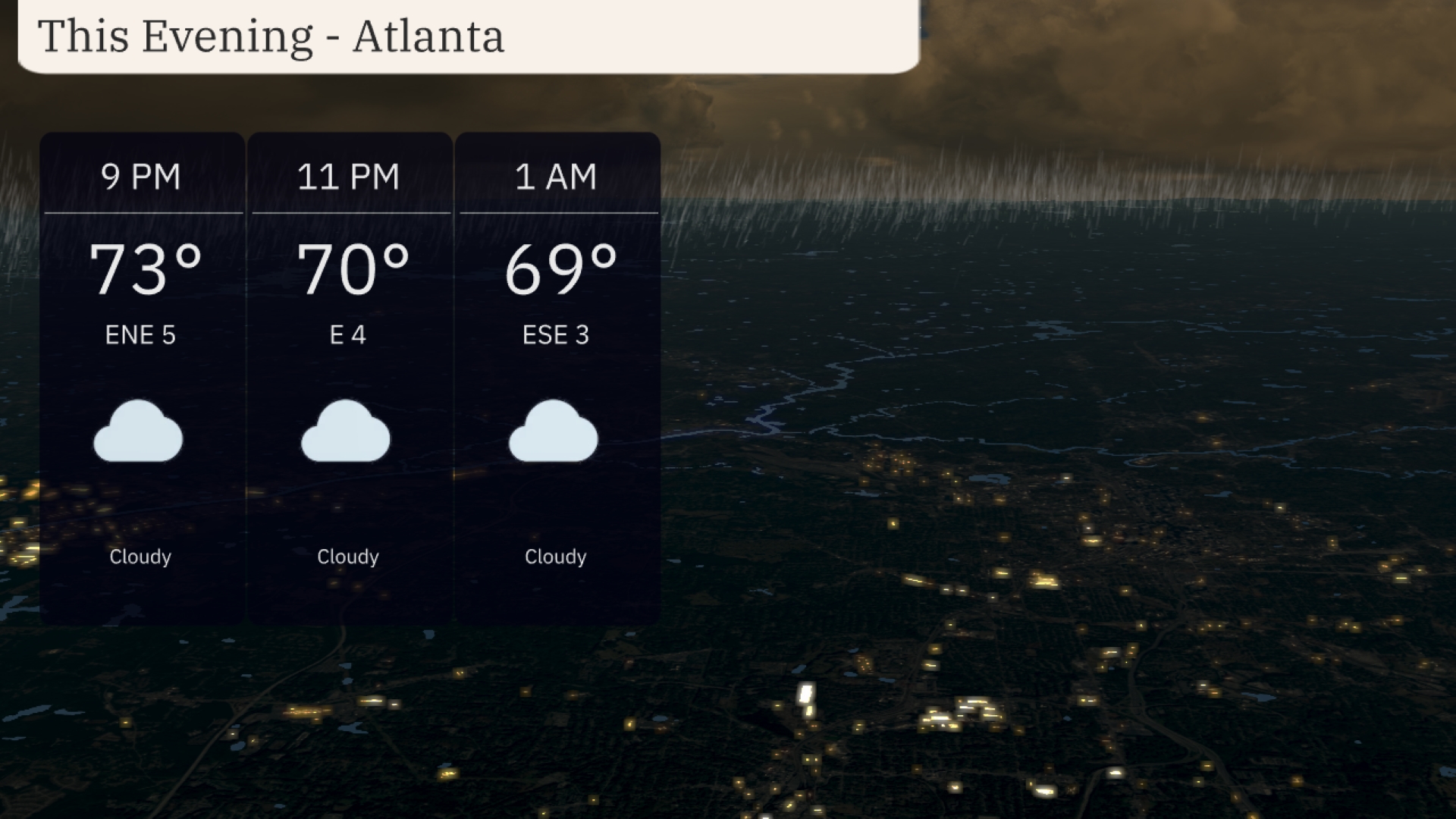
In Atlanta this evening, temperatures will gradually decrease from 73 degrees at 9 PM to 69 degrees by 1 AM. The winds are mainly light, shifting from east-northeast at 5 miles per hour to east-southeast at 3 miles per hour. Cloudy conditions will persist throughout the evening. The calm winds contribute to a serene night under a blanket of clouds.
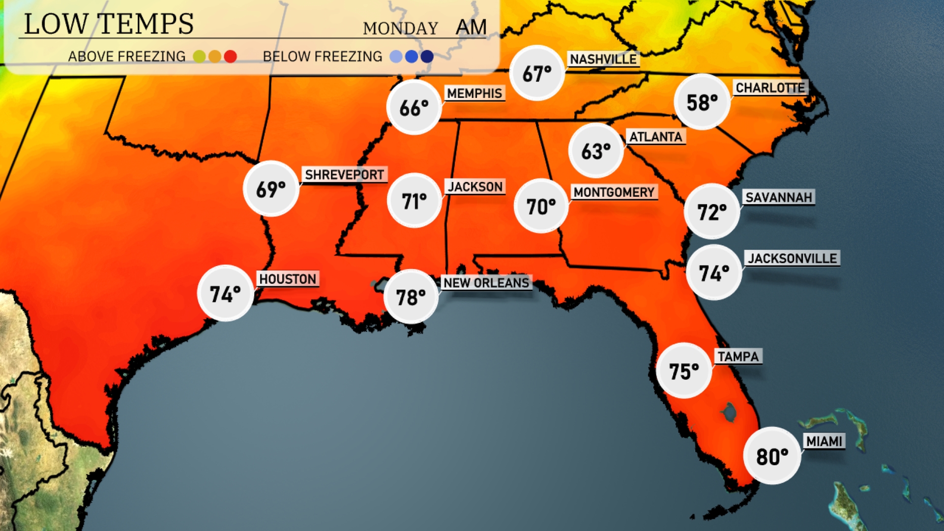
Tonight in the Southeast, expect mild temperatures with lows remaining above average for this time of year. Memphis will cool down to a comfortable 66 degrees, while Jackson will see 71. New Orleans stays warm at 78, with Tampa slightly behind at 75. Atlanta is forecasted to drop to 63 degrees, making it a cooler night compared to recent temperatures. The Carolinas will feel the chill as Charlotte dips to 58 degrees, marking a notable cool down in the region.
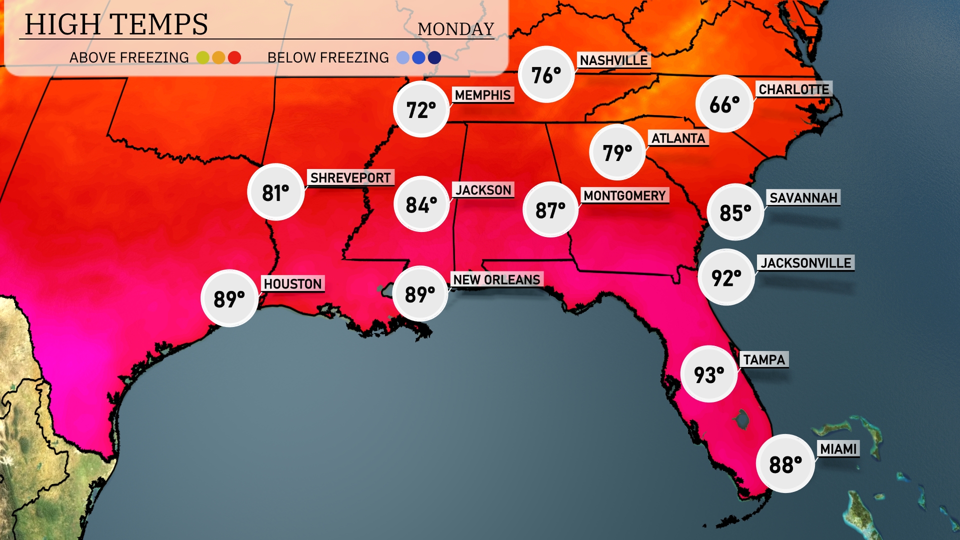
Tomorrow’s high temperatures will be notably warm across the Southeast, with many locations experiencing above-average readings. Atlanta is expected to reach 79 degrees, while Montgomery follows closely at 87 degrees. Jacksonville will see a significant high of 92 degrees, leading the pack in Florida, where Tampa is also warm at 93 degrees. New Orleans and Houston are both forecasted to have highs of 89 degrees, making it a hot day for the Gulf Coast. Overall, dry air will contribute to these elevated temperatures, particularly in Florida, where summer-like conditions are starting to set in.
A strong weather system is sweeping across the Southeast, impacting states from Texas to the Carolinas. Expect heavy rain and thunderstorms from Shreveport to Atlanta as the front advances eastward. Strong winds and potential isolated tornadoes are possible, especially in Louisiana and Mississippi areas. Rain showers are set to reach Montgomery, triggering flooding concerns due to the deluge. Once the front passes, cooler, clearer conditions are anticipated, but remain alert through Wednesday for updates on severe weather risks.
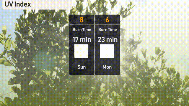
The UV index in Atlanta will be high on Sunday with a level of 8, resulting in a burn time of about 17 minutes if you’re in direct sunlight. On Monday, the index lowers slightly to 6, with a burn time of approximately 23 minutes. Be sure to wear sunscreen and protective clothing to reduce sun exposure risk.
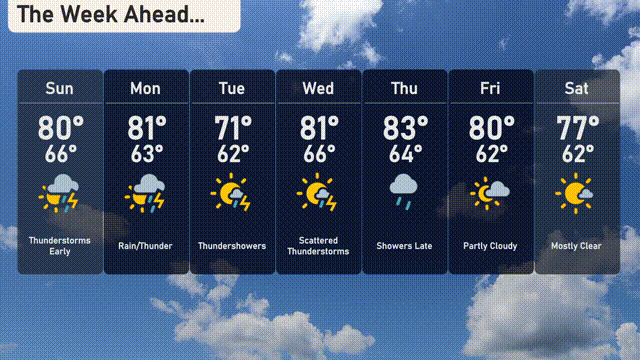
For the 7-day forecast in Atlanta:
Tuesday: Thunderstorms with a high of 71 degrees and a low of 62 degrees.
Wednesday: Scattered thunderstorms, expect a high of 81 degrees and a low of 66 degrees.
Thursday: Showers late with temperatures reaching 83 degrees during the day and a low of 64.
Friday: Partly cloudy skies bringing a high of 80 degrees and a low of 62.
Saturday: Mostly clear, alongside a high of 77 degrees, cooling to 62 overnight.
Sunday: Early thunderstorms, and temperatures will peak at 80 degrees with a low of 66.
Monday: Rain and thunder expected with a high of 81 and lows around 63.
Stay safe!