Weather Whiplash in the Southeast: Clear Skies to Thunderstorms
By
Amy Freeze
Meteorologist Amy Freeze delivers comprehensive coverage on the dynamic weather patterns from serene skies in Atlanta to wild weather fronts in the Gulf. Dive into your local forecast now.
Atlanta enjoys clear skies today, but a line of storms is making its way through the Southeast. Get the full weather report from Amy Freeze for your area’s forecast.
Get a detailed breakdown of today’s varying weather conditions across the Southeast from Meteorologist Amy Freeze. From the humidity-warmed fields of Georgia to the rainy vibes in Miami, understand the atmospheric changes and how they might affect your week ahead. Plus, we offer practical tips to cope with high UV indexes and sudden temperature changes.
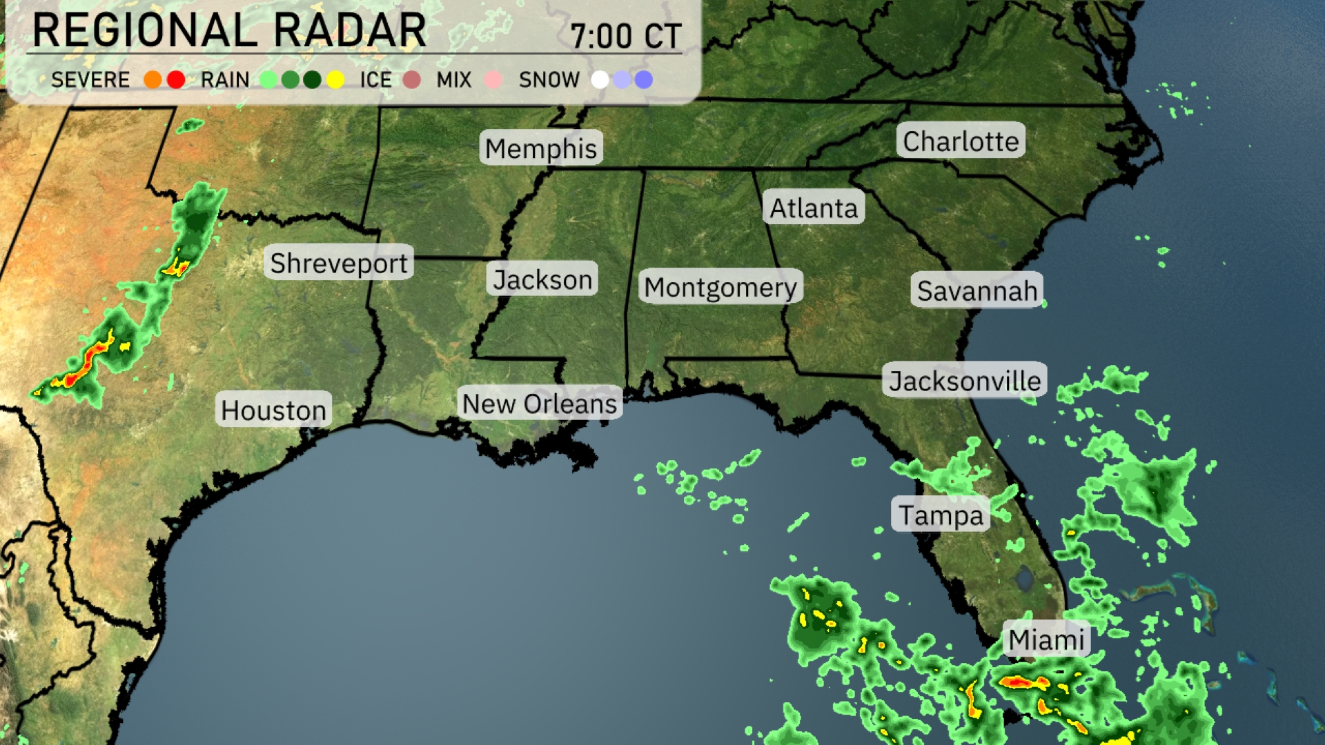
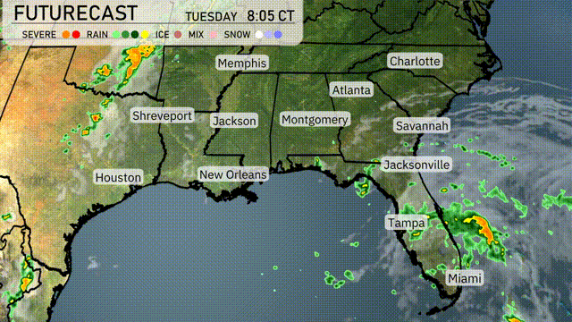
A line of storms is sweeping through the Southeast, primarily moving eastward. Jacksonville is currently experiencing showers, with rain extending south towards Miami. In the Gulf, rain bands are slowly drifting towards New Orleans. Georgia and the Carolinas remain mostly under clear skies but warm, humid conditions are in play, priming the atmosphere for potential weather changes. Houston and Shreveport may also see isolated thunderstorms developing as the evening unfolds.
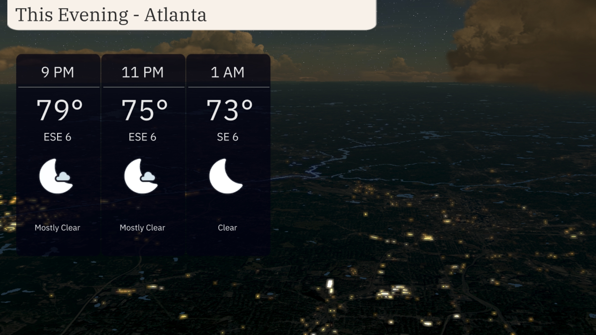
This evening in Atlanta, enjoy mostly clear skies with temperatures starting at 79 degrees at 9 PM and gradually cooling to 73 degrees by 1 AM. Winds will be gentle from the east-southeast at 6 miles per hour, making outdoor activities quite pleasant.
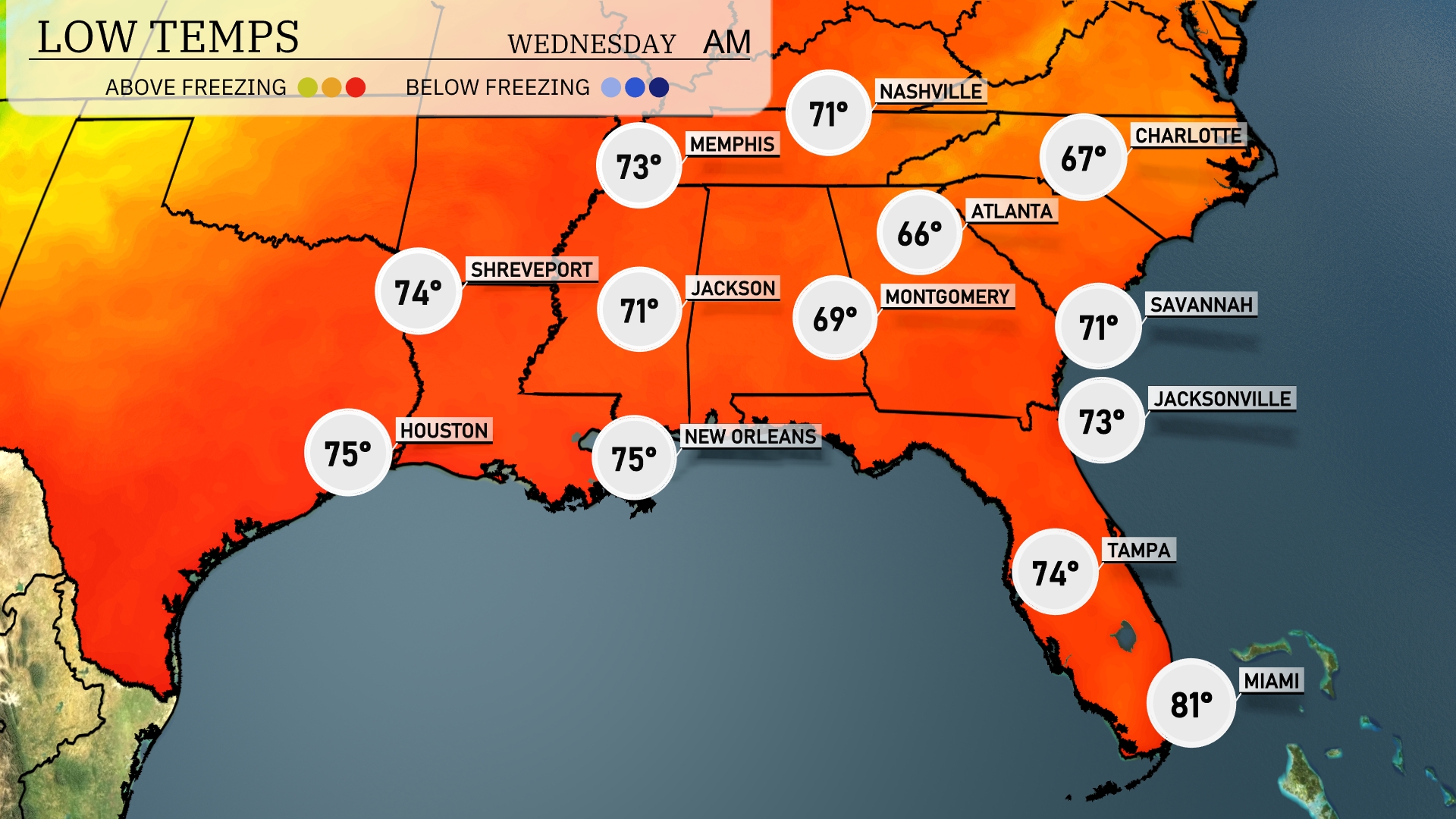
Tonight, the Southeast will experience relatively mild temperatures, with lows ranging from the mid-60s to mid-70s. Atlanta is slated to drop to 66 degrees, while Montgomery will cool to 69. Expect 71 degrees in Jackson and Savannah, and a balmy 73 in Jacksonville. Shreveport will see a low of 74, while New Orleans matches that with 75. Miami stands out with an overnight low of 81 degrees, remaining quite warm.
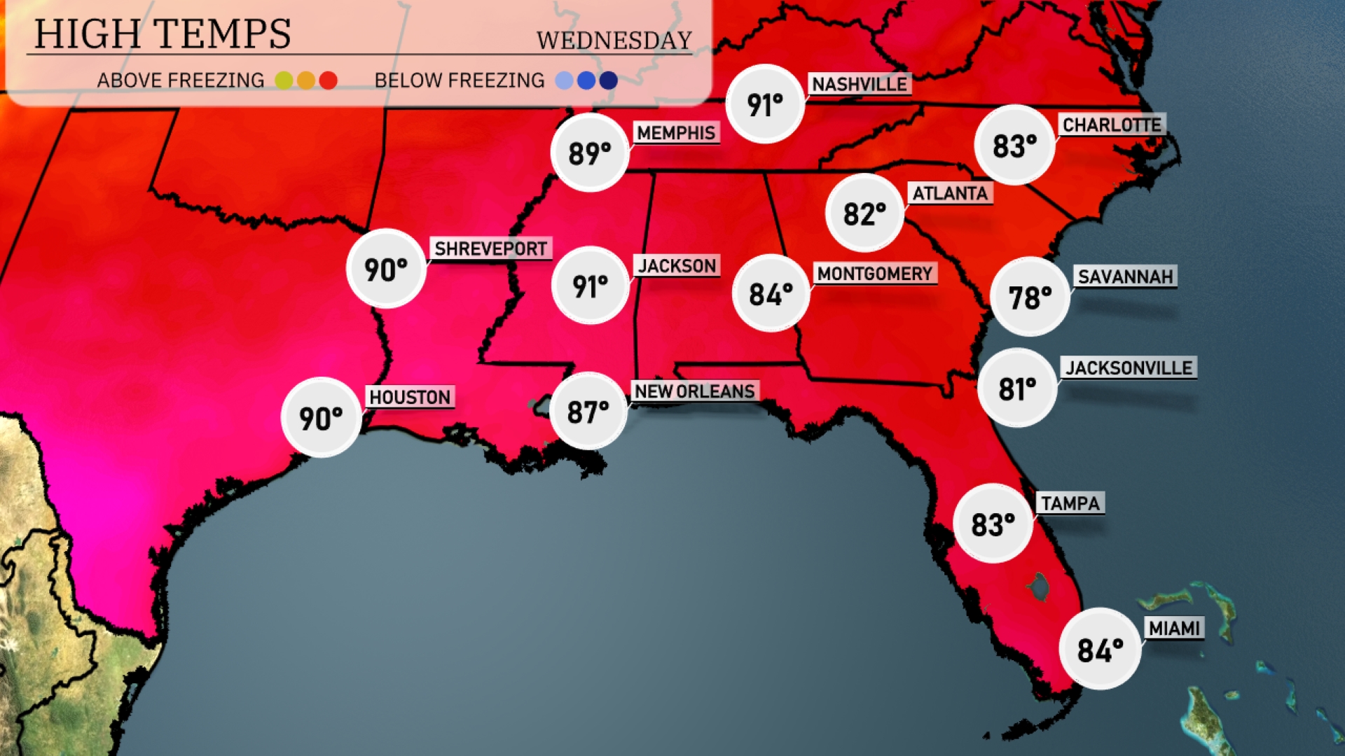
Tomorrow, the Southeast is gearing up for unseasonably high temperatures. Jacksonville will see a high of 81 degrees, while Atlanta can expect a warm 82 degrees. New Orleans hits 87 degrees, and Jackson reaches a sizzling 91 degrees. In contrast, Savannah will be slightly cooler at 78 degrees.
A cold front brings heavy rain and thunderstorms to the Southeast on Wednesday. Expect potential severe weather with damaging winds and localized flooding, especially from northern Alabama to western Georgia. Rainfall could exceed two inches in some areas, raising concerns over quick urban flooding. Behind the front, cooler and drier air settles, bringing a temporary relief from the recent humidity.
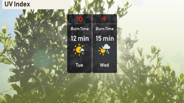
The UV index in Atlanta is extremely high at 10 on Tuesday, meaning sunburn can occur in just 12 minutes. Remember to apply high-SPF sunscreen, wear hats, and seek shade when possible. Wednesday brings a slightly lower UV index of 9, with a burn time of approximately 15 minutes.
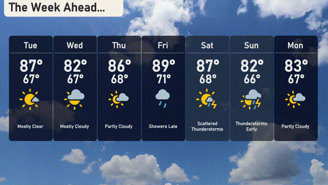
For the 7-day forecast in Atlanta:
Tuesday: Mostly clear with a high of 87 degrees and a low of 67.
Wednesday: Mostly cloudy skies with temperatures peaking at 82 degrees and a low of 67.
Thursday: Expect partly cloudy weather with a high of 86 degrees and a nighttime low of 68.
Friday: Late showers develop with a high reaching 89 degrees and a low of 71.
Saturday: Scattered thunderstorms with temperatures reaching up to 87 degrees and dipping to 68.
Sunday: Early thunderstorms with a daytime high of 82 degrees, dropping to a low of 66.
Monday: Partly cloudy, ending the forecast with a high of 83 degrees and a low of 67.