From Sun to Storms: Your Comprehensive Southeast Weather Guide by Amy Freeze
By
Amy Freeze
Meteorologist Amy Freeze delivers an in-depth analysis of fluctuating weather patterns across the Southeast, from serene skies to storm surges.
Dive into our detailed weather analysis with Amy Freeze, highlighting everything from thunderstorms across major cities to the serene climatic conditions in others. Stay updated with our tailored weather insights!
Welcome to your trusted source for Southeast weather updates! Follow along as Amy Freeze tracks a variety of conditions ranging from heavy thunderstorms to clear, sunny skies. Understand how these conditions could affect your week and learn what to expect temperature-wise with our city-by-city breakdown. Comprehensive, insightful, and always accurate—ensure you’re prepared for whatever the weather throws your way.
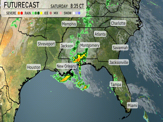
The Southeast region is currently witnessing a mixture of weather conditions. Over Houston and extending toward New Orleans, a line of strong thunderstorms is progressing eastward, bringing significant rainfall. Shreveport is already in the midst of heavy rain, with the wet conditions expected to move toward Jackson. To the northeast, Memphis experiences scattered showers, while the storms intensify. Savannah and Charleston enjoy a reprieve under clear skies, but Charlotte and Atlanta should prepare for an increase in cloud cover. Miami and Tampa remain clear and dry, setting a contrast to the stormy conditions further west.
This evening in Atlanta, expect mostly cloudy skies with a southeast wind at 6 to 7 miles per hour. Temperatures start at 69 degrees at 8 PM, cooling slightly to 65 degrees by midnight.
Now for the low temperatures, the Southeast will experience a chilly night ahead. Memphis will dip to 53 degrees. Nashville is forecasted to see a low of 59. In Jackson, expect temperatures to drop down to 63. Montgomery will be slightly warmer at 68 degrees. Moving south, New Orleans will see a low of 71, while Shreveport will rest at a cooler 59 degrees. Atlanta is looking at 63, and further down the coast, Jacksonville will be at 66. Over in Savannah, temperatures will settle at 65 degrees, while Tampa enjoys a mild night at 69, with Miami rounding out the region at 73 degrees.
For high temperatures tomorrow across the Southeast, we’re looking at a warm day with several cities reaching above-average readings.
In Houston, expect a high of 82 degrees.
Shreveport will see slightly warmer conditions at 83 degrees.
Moving east, Jackson is set to reach a sizzling 84 degrees.
New Orleans will also be warm with temperatures hitting 82 degrees.
In Alabama, Montgomery is forecasted for a high of 79 degrees.
Farther south, Jacksonville will see a high of 78 degrees, while Tampa is anticipated to be at 84 degrees.
Miami rounds it out with a pleasant 79 degrees.
“Keep an eye on the Southeast tomorrow, where a robust weather pattern emerges. A line of strong thunderstorms is on the cards as a cold front advances from the west. Areas from New Orleans to Montgomery will experience afternoon storms with potential heavy rain and gusty winds. As the front moves, expect thunderstorms extending from Jacksonville to Charlotte by evening. The Storm Prediction Center has parts of this region highlighted for severe risk, so stay alert for any weather warnings. Rain totals could be significant, bringing well-needed relief but also a chance for localized flooding. Temperatures remain warm but will trend cooler post-front, calming down as we head into the weekend.”
The UV index in Atlanta on Saturday is at a moderate level of 5, with potential sun exposure risks including a burn time of about 27 minutes in direct sunlight. On Sunday, the UV index drops to a low level of 2.
For the 7 Day Outlook in Atlanta:
Saturday: It will be cloudy with a high of 76 degrees and a low of 61.
Sunday: Thunderstorms are expected to develop late in the day, with temperatures reaching 73 degrees and a low of 64.
Monday: Look for clouds early with a clearing trend in the afternoon. The high will be 69 degrees, cooling down to 45 at night.
Tuesday: Partly cloudy conditions will prevail, with temperatures peaking at 77 degrees and a low of 59.
Wednesday: Enjoy partly cloudy skies and a high of 81 degrees, dipping to 65 degrees overnight.
Thursday: Expect mostly clear weather with a high of 86 degrees and a low around 64 degrees.
Friday: The day will be mostly cloudy with temperatures reaching 87 degrees and a low of 65.
Hope you have a fantastic week ahead!